1970s Maps of Orange County, Indiana
Explore 5 historic maps of Orange County from the 1970s. These maps offer a rare glimpse into what life looked like during the 1970s — showing old roads, neighborhoods, homes, and landmarks that have changed or disappeared over time.
Whether you're researching your family's past, planning a metal detecting trip, or studying how Orange County's landscape evolved across the 1970s, these high-resolution maps are a powerful tool for exploring the history of this region.
- Focus on a specific era: All maps on this page are from the 1970s, giving you a focused view of this time period.
- See what’s changed: Compare century-old streets, trails, and buildings to today's modern landscape using overlays and satellite layers.
- Research with precision: Use these maps for genealogy, historical research, land use analysis, or educational projects.
- View, download, or print: Maps are fully viewable online in high resolution, and can be downloaded or printed for your own records.
Start exploring Orange County's history through authentic maps from the 1970s. This is your window into the past.
Orange County, IN maps
(5)- 1970 Map of Paoli, 1972 Print
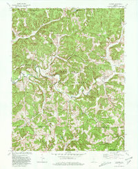
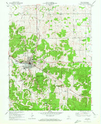 1970 Paoli1972 Print · USGSIndiana's hilly southern interior is captured here in the early seventies, centered on the historic crossroads of Paoli. Local researchers can trace old property lines against the Old Indian Treaty Boundary or locate rural landmarks like Braxtons Siding, Stouts Chapel, and Syria.3 unique versions available
 - 1970 Map of Campbellsburg, 1972 Print
 1970 Campbellsburg1972 Print · USGSSouthern Indiana rail and river life converge here during the early seventies, centered on the MONON line. Researchers can trace the layout of small settlements like Saltillo and Campbellsburg or locate rural landmarks like Fishing Creek Chapel and Freedom Cem.2 unique versions available
 - 1970 Map of Valeene, 1972 Print
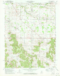
 1970 Valeene1972 Print · USGSSouthern Indiana's rugged backcountry is shown in the early seventies, featuring the foundational surveying point for the entire state. Researchers can trace the Old Indian Treaty Boundary and locate family sites like Purkhiser Cem or the rural settlement of Valeene.
 - 1970 Map of Livonia, 1972 Print
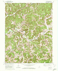
 1970 Livonia1972 Print · USGSIndiana's limestone country in the early seventies reveals a landscape of sinking streams and rural crossroads. Genealogists can trace family roots through landmarks like Lost River Ch, Posey Chapel, and the small settlement of Bromer.
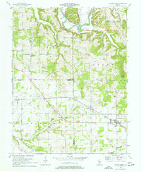
 - 1979 Map of Valeene, 1980 Print
 1979 Valeene1980 Print · USGSSouthern Indiana's heavily forested hills meet the waters of Patoka Lake in this late-seventies survey. Genealogists can trace family roots through rural communities like Valeene and Pearsontown or locate the historic Initial Point Historical Monument.
End of results
Showing maps 1-5 of 5
Top cities of Orange County
- Paoli historical maps
- Orleans historical maps
- French Lick historical maps
- Stampers Creek historical maps
- Orangeville historical maps
- West Baden Springs historical maps
Frequently asked questions
- What are the different types of historical maps available for Orange County?
- What is the oldest map of Orange County?
- Where can I purchase historical maps of Orange County for my home or office?
- Where can I download high-res historical maps of Orange County?
- Are there historical topographic maps available for Orange County?
- Is there historical aerial imagery available for Orange County?
- Where are historical maps of Orange County sourced from?