1960s Maps of Parke County, Indiana
Explore 11 historic maps of Parke County from the 1960s. These maps offer a rare glimpse into what life looked like during the 1960s — showing old roads, neighborhoods, homes, and landmarks that have changed or disappeared over time.
Whether you're researching your family's past, planning a metal detecting trip, or studying how Parke County's landscape evolved across the 1960s, these high-resolution maps are a powerful tool for exploring the history of this region.
- Focus on a specific era: All maps on this page are from the 1960s, giving you a focused view of this time period.
- See what’s changed: Compare century-old streets, trails, and buildings to today's modern landscape using overlays and satellite layers.
- Research with precision: Use these maps for genealogy, historical research, land use analysis, or educational projects.
- View, download, or print: Maps are fully viewable online in high resolution, and can be downloaded or printed for your own records.
Start exploring Parke County's history through authentic maps from the 1960s. This is your window into the past.
Parke County, IN maps
(11)- 1960 Map of Brazil East
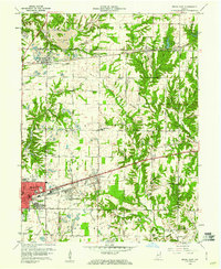 1960 Brazil East1960 Print · USGSClay County at the dawn of the 1960s shows a landscape of busy coal pits and industrial towns. Genealogists and historians can trace family locations near Knightsville, search for burials at Calcutta Cem, or follow the path of the Pennsylvania Railroad.3 unique versions available
 - 1960 Map of Brazil West, 1961 Print
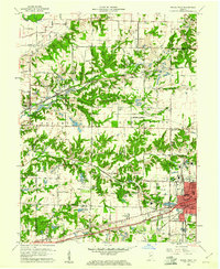 1960 Brazil West1961 Print · USGSThe coal country of Clay and Vigo counties is captured here in the early sixties, showing an era of intensive strip mining and rail transport. Genealogists can locate family names at Cottage Hill Cem and Archer Cem or trace vanished rail stops like Cobb and Billville.3 unique versions available
 - 1961 Map of Wallace, 1962 Print
 1961 Wallace1962 Print · USGSWestern Indiana during the early sixties reveals a landscape of deep creek valleys and traditional river crossings. Genealogists and historians can trace the locations of the Wilkins Mill Covered Bridge, Turkey Run School, and the rural community of Wallace.3 unique versions available
 - 1961 Map of Alamo, 1962 Print
 1961 Alamo1962 Print · USGSThe rural landscape of Montgomery County during the early sixties is dominated by the winding path of Sugar Creek and the southern edge of Shades State Park. Researchers can find fascinating relics of local history, from the Deer Mill and its Covered Bridge to the Pennsylvania rail line serving Waveland.3 unique versions available
 - 1962 Map of Indianapolis
 1962 Indianapolis1962 Print · USGSCentral Indiana and the Illinois borderlands are captured here in the early sixties, showing the region's dense rail networks and growing urban centers. Genealogists and historians can locate family-named landmarks and institutions like Crown Hill Cem, Indiana University, and the Indianapolis Motor Speedway.
 - 1962 Map of Rosedale, 1964 Print
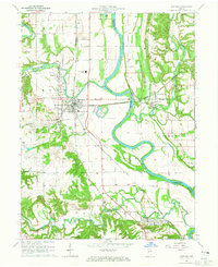
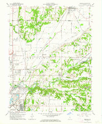 1962 Rosedale1964 Print · USGSThe Parke and Vigo county line was a bustling rail hub in the early sixties, centered on the convergence of major lines. Researchers can trace the development of Rosedale and North Terre Haute or locate family sites like Kennedy Cem and Sulphur Spring Ch.3 unique versions available
 - 1963 Map of Bellmore, 1964 Print
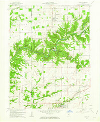
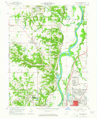
 1963 Bellmore1964 Print · USGSEastern Parke County is captured here just as the landscape was transforming with the completion of the Mansfield Reservoir. Researchers can trace old family burial grounds like Lough Cem or follow the rail lines through Guion and Milligan.3 unique versions available
 - 1963 Map of Mecca, 1964 Print
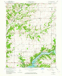
 1963 Mecca1964 Print · USGSParke County's river valleys and railroad crossings are documented here in the early sixties, showing a landscape defined by the Wabash and Big Raccoon Creek. Genealogists and historians can trace old settlements like Mecca and Jessup, or locate regional landmarks like the Roseville Covered Bridge and Hixon Cem.3 unique versions available
 - 1963 Map of Mansfield, 1964 Print
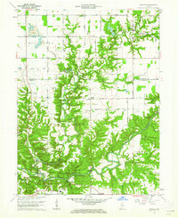
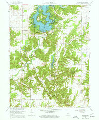 1963 Mansfield1964 Print · USGSParke County in the early sixties shows a landscape transformed by the waters of Cecil M Harden Lake. Genealogists and historians can locate legacy sites like the Covered Bridge at Mansfield, Zion Chapel, and the Miller Cem burial grounds.4 unique versions available
 - 1963 Map of New Goshen, 1965 Print
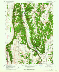
 1963 New Goshen1965 Print · USGSThe West Central Indiana borderlands come into focus in the early sixties as industrial coal mining and river transport converge. Researchers can trace the historic Erie Canal alignment or locate family roots at St Mary-of-the-Woods College and Barbour Cem.4 unique versions available
 - 1964 Map of Newport, 1965 Print
 1964 Newport1965 Print · USGSThe Wabash and Vermilion rivers meet in this mid-1960s Indiana landscape, tracing a region defined by river-bottom farms and rail transport. Genealogists can locate family burial grounds like Groenendyke Cem or landmarks such as the Collett Orphanage and Waterman Ch.2 unique versions available
End of results
Showing maps 1-11 of 11
Top cities of Parke County
- Rockville historical maps
- Montezuma historical maps
- Rosedale historical maps
- Marshall historical maps
- Mecca historical maps
- Howard historical maps
See more
Frequently asked questions
- What are the different types of historical maps available for Parke County?
- What is the oldest map of Parke County?
- Where can I purchase historical maps of Parke County for my home or office?
- Where can I download high-res historical maps of Parke County?
- Are there historical topographic maps available for Parke County?
- Is there historical aerial imagery available for Parke County?
- Where are historical maps of Parke County sourced from?