Old Maps of Parke County, Indiana for Hiking & Exploration
Hike through history with 116 historic maps of Parke County. Explore old trails, ghost towns, and forgotten backroads — perfect for outdoor adventurers and local explorers.
- Rediscover forgotten places: Map out old mining camps, roads, and footpaths that no longer exist on modern maps.
- Layer with modern tools: Combine with LiDAR or satellite views to plan hikes through historical terrain.
- Made for exploration: Popular among hikers, overlanders, and local history lovers.
Use these maps to find adventure and explore the hidden past of Parke County.
Parke County, IN maps
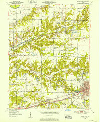
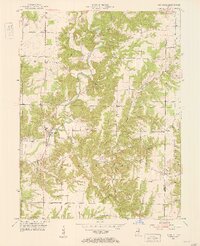
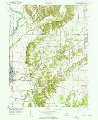
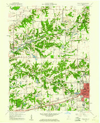
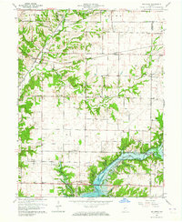
(116)- 1948 Map of Wallace
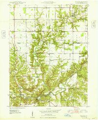 1948 Wallace1948 Print · USGSFountain and Parke Counties are captured here in the late 1940s as a landscape of rural crossroads and river bottomlands. Genealogists can trace family connections through sites like Cashet Cem, Lusk Chapel, and the early layout of Wallace.2 unique versions available
 - 1949 Map of Alamo
 1949 Alamo1949 Print · USGSThe rugged valleys of Montgomery and Parke counties are documented here in the late 1940s, just as the area's natural landmarks gained prominence. Researchers can locate long-standing rural institutions like Liberty Sch, Freedom Ch, and the old grounds of Deer Mill.
 - 1950 Map of Rosedale, 1952 Print
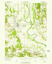
 1950 Rosedale1952 Print · USGSThe rail-and-creek landscape of Parke and Vigo counties comes alive in this mid-century survey. Trace family roots and vanished rail stops through settlements like Atherton, Sandcut, and Burnett, or locate country landmarks like Friendship Ch and Markles Cem.2 unique versions available
 - 1950 Map of Brazil East, 1952 Print
 1950 Brazil East1952 Print · USGSClay County at mid-century was a landscape defined by coal and transit, as massive industrial earthworks reshaped the outskirts of its communities. Genealogists and historians can trace the foundations of Brazil and Knightsville or locate rural landmarks like Wesley Chapel and Calcutta Cem.
 - 1950 Map of Brazil West, 1952 Print
 1950 Brazil West1952 Print · USGSClay County's western coalfields are shown in the 1950s as a landscape of active extraction and heavy rail transport. Genealogists and historians can locate numerous rural burial grounds like St Marys Cem alongside vanished industrial sites and the streets of Brazil.
 - 1950 Map of New Goshen, 1952 Print
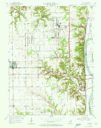
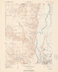 1950 New Goshen1952 Print · USGSVigo County in the early fifties is captured here as a landscape of river-side industry and emerging suburbs north of Terre Haute. Researchers can locate the historic St Mary-of-the-Woods College or trace the path of the Erie Canal (Abandoned) past Shepardsville and Tecumseh.3 unique versions available
 - 1951 Map of Clinton, 1953 Print
 1951 Clinton1953 Print · USGSClinton and the Wabash River valley are captured in the early fifties, a time when coal extraction and rail transport defined the local economy. Researchers can trace family landmarks and schools like Higgins Mathews Sch and Glendale Sch, or locate the many Strip Mine sites that once dotted the landscape near Centenary and Klondyke.2 unique versions available
 - 1951 Map of Mecca, 1953 Print
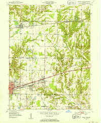
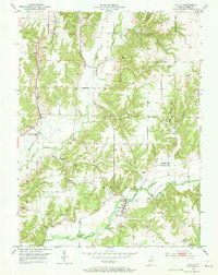
 1951 Mecca1953 Print · USGSParke County in the early fifties shows a landscape shaped by clay manufacturing and a dense network of steam railroads. Researchers can trace the industrial Kilns at Mecca, find rural landmarks like the Thorpe Ford Bridge, or locate family sites at Union Cem and Bethel Ch.2 unique versions available
 - 1951 Map of Mansfield, 1953 Print
 1951 Mansfield1953 Print · USGSParke and Putnam Counties are captured here in the early fifties, documenting the rural character of the West-Central Indiana highlands. Genealogists can locate family-named sites such as Roach Cem, Miller Cem, and community landmarks like Zion Chapel or the village of Ferndale.2 unique versions available
 - 1952 Map of Catlin, 1953 Print
 1952 Catlin1953 Print · USGSParke County in the early fifties shows a rural landscape of creek-side settlements and active industry. Genealogists and historians can trace family locations at Bridgeton and Catlin, or locate old landmarks like the Jeffries Ford Bridge and Mt Olivet Ch.2 unique versions available
 - 1953 Map of Indianapolis, 1965 Print
 1953 Indianapolis1965 Print · USGSCentral Indiana and the Illinois borderlands are captured in the mid-sixties, showing the growth of Indianapolis and its industrial rail corridors. Genealogists and historians can trace the development of outlying towns like Zionsville or Beech Grove and find landmarks such as Atterbury AAF and Turkey Run State Park.4 unique versions available
 - 1955 Map of Rockville, 1956 Print
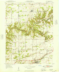
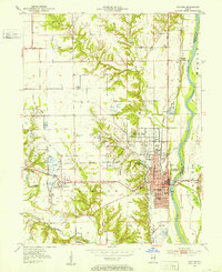
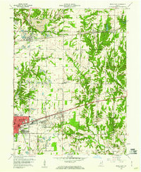
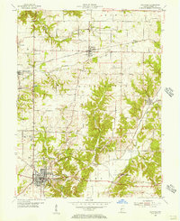 1955 Rockville1956 Print · USGSParke County in the mid-1950s reveals a classic Indiana landscape of rail-connected towns and rural institutions. Researchers can trace family roots through several local burial sites like Sand Creek Ch Cem and explore the historic footprint of the State Sanatorium.2 unique versions available
 - 1955 Map of Kingman, 1956 Print
 1955 Kingman1956 Print · USGSFountain and Parke Counties are mapped in the mid-1950s as a network of rail-connected towns and deep creek valleys. Genealogists can trace family landmarks like Bethel Cem, Township Sch, and the rail junction at Kingman.2 unique versions available
 - 1955 Map of Montezuma, 1957 Print
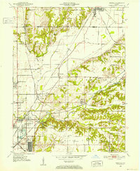
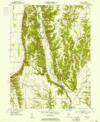
 1955 Montezuma1957 Print · USGSWestern Parke County comes alive in the mid-1950s, showing a river-and-rail landscape where historical boundaries meet industrial growth. Trace the path of the Abandoned Canal and locate family landmarks like Linebarger Chapel and Hethcoe Cem.2 unique versions available
 - 1955 Map of Dana, 1957 Print
 1955 Dana1957 Print · USGSVermillion County mid-century life centers on the massive Wabash River Ordnance Works and the rail-side town of Dana. Genealogists and historians can locate numerous small burial grounds like Carmack Cem and trace the path of the Abandoned Canal along the river.2 unique versions available
 - 1955 Map of Newport, 1957 Print
 1955 Newport1957 Print · USGSVermillion and Fountain counties meet at the Wabash River during the mid-fifties, showing a landscape shaped by rail and river commerce. Genealogists can trace family names at the Collette Orphanage or find rural burial grounds like Groenendyke Cem and Isle Cem.
 - 1956 Map of Indianapolis
 1956 Indianapolis1956 Print · USGSCentral Indiana in the mid-fifties is captured during a period of industrial growth and military presence. Genealogists and historians can trace the rail networks of the New York Central or locate regional landmarks like Fort Benjamin Harrison and Camp Atterbury.
 - 1957 Map of Indianapolis
 1957 Indianapolis1957 Print · USGSCentral Indiana in the mid-fifties is captured here as a crossroads of major rail lines and nascent federal highways. Genealogists and historians can trace family-named ridges like Poplar Ridge or locate strategic sites like Camp Atterbury and Speedway.2 unique versions available
 - 1960 Map of Brazil East
 1960 Brazil East1960 Print · USGSClay County at the dawn of the 1960s shows a landscape of busy coal pits and industrial towns. Genealogists and historians can trace family locations near Knightsville, search for burials at Calcutta Cem, or follow the path of the Pennsylvania Railroad.3 unique versions available
 - 1960 Map of Brazil West, 1961 Print
 1960 Brazil West1961 Print · USGSThe coal country of Clay and Vigo counties is captured here in the early sixties, showing an era of intensive strip mining and rail transport. Genealogists can locate family names at Cottage Hill Cem and Archer Cem or trace vanished rail stops like Cobb and Billville.3 unique versions available
 - 1961 Map of Wallace, 1962 Print
 1961 Wallace1962 Print · USGSWestern Indiana during the early sixties reveals a landscape of deep creek valleys and traditional river crossings. Genealogists and historians can trace the locations of the Wilkins Mill Covered Bridge, Turkey Run School, and the rural community of Wallace.3 unique versions available
 - 1961 Map of Alamo, 1962 Print
 1961 Alamo1962 Print · USGSThe rural landscape of Montgomery County during the early sixties is dominated by the winding path of Sugar Creek and the southern edge of Shades State Park. Researchers can find fascinating relics of local history, from the Deer Mill and its Covered Bridge to the Pennsylvania rail line serving Waveland.3 unique versions available
 - 1962 Map of Indianapolis
 1962 Indianapolis1962 Print · USGSCentral Indiana and the Illinois borderlands are captured here in the early sixties, showing the region's dense rail networks and growing urban centers. Genealogists and historians can locate family-named landmarks and institutions like Crown Hill Cem, Indiana University, and the Indianapolis Motor Speedway.
 - 1962 Map of Rosedale, 1964 Print
 1962 Rosedale1964 Print · USGSThe Parke and Vigo county line was a bustling rail hub in the early sixties, centered on the convergence of major lines. Researchers can trace the development of Rosedale and North Terre Haute or locate family sites like Kennedy Cem and Sulphur Spring Ch.3 unique versions available
 - 1963 Map of Bellmore, 1964 Print
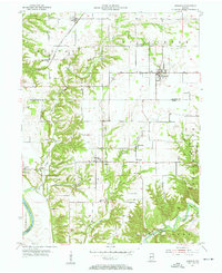
 1963 Bellmore1964 Print · USGSEastern Parke County is captured here just as the landscape was transforming with the completion of the Mansfield Reservoir. Researchers can trace old family burial grounds like Lough Cem or follow the rail lines through Guion and Milligan.3 unique versions available
Showing maps 1-25 of 116
Top cities of Parke County
- Rockville historical maps
- Montezuma historical maps
- Rosedale historical maps
- Marshall historical maps
- Mecca historical maps
- Howard historical maps
See more
Frequently asked questions
- What are the different types of historical maps available for Parke County?
- What is the oldest map of Parke County?
- Where can I purchase historical maps of Parke County for my home or office?
- Where can I download high-res historical maps of Parke County?
- Are there historical topographic maps available for Parke County?
- Is there historical aerial imagery available for Parke County?
- Where are historical maps of Parke County sourced from?