
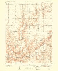
1948 Map of Wallace
USGS Topo · Published 1948About this map
Turkey Run State Park anchors the southern portion of this landscape, where the winding course of Sugar Creek has carved deep drainages like Rocky Hollow. This 1940s survey reveals a rural economy in transition, where traditional farming and small settlements like Wallace and Grange Corner exist alongside emerging industrial activity. In the north, several prominent Strip Mine operations are mapped, while the presence of historic crossings like Cox Ford Bridge and religious centers such as Friends Union Ch, Phanuel Ch, and Lusk Chapel mark the established social fabric of the era. The land is heavily dissected by a dense network of waterways including Mill Creek, Buffalo Creek, and Wolf Creek, many of which are flanked by family-named landmarks and cemeteries like Nolen Cem and Cashet Cem, providing valuable data for genealogical research into the families of Fountain and Parke Counties.
Find a feature on this map
31 named features on this map. Tap any name to fly to it.
Don’t see what you’re looking for? This feature index may not catch every label — zoom into the map to look around manually.
Map Details
Editions of this 1948 Wallace Map
2 editions found
Other maps of this area

1949 · Alamo
USGS Topo · 1:24,000

1953 · Danville
USGS Topo · 1:250,000

1953 · Indianapolis
USGS Topo · 1:250,000

1955 · Danville
USGS Topo · 1:250,000

1955 · Rockville
USGS Topo · 1:24,000

1955 · Kingman
USGS Topo · 1:24,000

1955 · Montezuma
USGS Topo · 1:24,000

1956 · Danville
USGS Topo · 1:250,000

1956 · Indianapolis
USGS Topo · 1:250,000

1957 · Indianapolis
USGS Topo · 1:250,000