
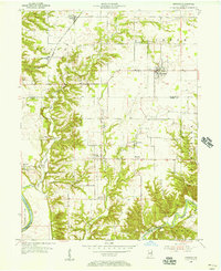
1955 Map of Kingman
USGS Topo · Published 1956About this map
Kingman serves as the central hub of this mid-century landscape where Fountain and Parke Counties meet. The terrain is defined by the complex drainages of Mill Creek and Rush Creek, which carve deep valleys through the agricultural uplands before reaching Sugar Creek and the Wabash River to the south and west. Significant transportation infrastructure of the era is evident in the Chicago and St Louis railroad line and family-linked crossings like the Bowsher Ford Bridge. The map records numerous rural centers and spiritual landmarks, including Mt Hermon, Sylvania, and Tangier, alongside many smaller family burial grounds such as Bethel Cem and Brittonridge Cem. The inclusion of the Porto-Woods Landing Field near the southern boundary reflects the evolving role of aviation in this largely agrarian environment during the 1950s.
Find a feature on this map
47 named features on this map. Tap any name to fly to it.
Don’t see what you’re looking for? This feature index may not catch every label — zoom into the map to look around manually.
Map Details
Editions of this 1955 Kingman Map
2 editions found
Other maps of this area

1948 · Wallace
USGS Topo · 1:24,000

1953 · Danville
USGS Topo · 1:250,000

1953 · Indianapolis
USGS Topo · 1:250,000

1955 · Danville
USGS Topo · 1:250,000

1955 · Rockville
USGS Topo · 1:24,000

1955 · Montezuma
USGS Topo · 1:24,000

1955 · Dana
USGS Topo · 1:24,000
1955 · Newport
USGS Topo · 1:24,000

1956 · Danville
USGS Topo · 1:250,000

1956 · Indianapolis
USGS Topo · 1:250,000