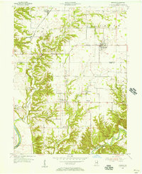
1955 Map of Kingman
USGS Topo · Published 1956About this map
Sugar Creek carves a deep, winding path through the southern landscape of this mid-1950s survey, marking a distinct transition from the flat agricultural uplands to the east. The township of Kingman serves as the primary hub, surrounded by a network of rural schools and small settlements like Tangier and Sylvania. Local genealogy is well-documented through a series of family-named burial grounds, including Ephlin Cem, Harvey Cem, and Norton Cem.
Find a feature on this map
39 named features on this map. Tap any name to fly to it.
Don’t see what you’re looking for? This feature index may not catch every label — zoom into the map to look around manually.
Map Details
Editions of this 1955 Kingman Map
2 editions found
Other maps of this area

1948 · Wallace
USGS Topo · 1:24,000

1953 · Danville
USGS Topo · 1:250,000

1953 · Indianapolis
USGS Topo · 1:250,000

1955 · Danville
USGS Topo · 1:250,000

1955 · Rockville
USGS Topo · 1:24,000

1955 · Kingman
USGS Topo · 1:24,000

1955 · Montezuma
USGS Topo · 1:24,000

1955 · Dana
USGS Topo · 1:24,000
1955 · Newport
USGS Topo · 1:24,000

1956 · Danville
USGS Topo · 1:250,000