1990s Maps of Valparaiso, Indiana
Explore 3 historic maps of Valparaiso from the 1990s. These maps offer a rare glimpse into what life looked like during the 1990s — showing old roads, neighborhoods, homes, and landmarks that have changed or disappeared over time.
Whether you're researching your family's past, planning a metal detecting trip, or studying how Valparaiso's landscape evolved across the 1990s, these high-resolution maps are a powerful tool for exploring the history of this region.
- Focus on a specific era: All maps on this page are from the 1990s, giving you a focused view of this time period.
- See what’s changed: Compare century-old streets, trails, and buildings to today's modern landscape using overlays and satellite layers.
- Research with precision: Use these maps for genealogy, historical research, land use analysis, or educational projects.
- View, download, or print: Maps are fully viewable online in high resolution, and can be downloaded or printed for your own records.
Start exploring Valparaiso's history through authentic maps from the 1990s. This is your window into the past.
Valparaiso, IN maps
(3)- 1991 Map of Kankakee
 1991 Kankakee1991 Print · USGSThe Illinois-Indiana borderlands come into focus during the early nineties, centered on the growing Kankakee valley and its sprawling drainage systems. Trace the rail-and-river economy through landmarks like the Wilton Railroad Grade, the Manteno State Hospital, and the historic Old Pioneer Cem.
 - 1991 Map of Chesterton, 1992 Print
 1991 Chesterton1992 Print · USGSIn the early nineties, the lakefront communities of Northwest Indiana were defined by their proximity to the dunes and heavy rail lines. Genealogists and historians can trace family sites at Augsburg Cem & Ch, the Old Indian Treaty Boundary, and the historic settlement of Crocker.
 - 1992 Map of Valparaiso
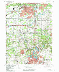
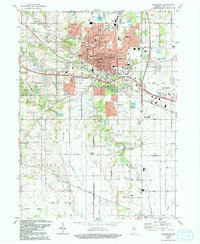 1992 Valparaiso1992 Print · USGSThe city of Valparaiso and its surrounding townships are shown here during a period of late-twentieth-century growth. Researchers can trace historical footprints at Valparaiso University, the Fairground, and various rural crossroads like Cobbs Corner and Malden.
End of results
Showing maps 1-3 of 3
Top cities near Valparaiso
- Gary historical maps
- Portage historical maps
- Michigan City historical maps
- Merrillville historical maps
- Hobart historical maps
- Lake Station historical maps
See more
Top neighborhoods of Valparaiso
Frequently asked questions
- What are the different types of historical maps available for Valparaiso?
- What is the oldest map of Valparaiso?
- Where can I purchase historical maps of Valparaiso for my home or office?
- Where can I download high-res historical maps of Valparaiso?
- Are there historical topographic maps available for Valparaiso?
- Is there historical aerial imagery available for Valparaiso?
- Where are historical maps of Valparaiso sourced from?