1960s Maps of Posey County, Indiana
Explore 6 historic maps of Posey County from the 1960s. These maps offer a rare glimpse into what life looked like during the 1960s — showing old roads, neighborhoods, homes, and landmarks that have changed or disappeared over time.
Whether you're researching your family's past, planning a metal detecting trip, or studying how Posey County's landscape evolved across the 1960s, these high-resolution maps are a powerful tool for exploring the history of this region.
- Focus on a specific era: All maps on this page are from the 1960s, giving you a focused view of this time period.
- See what’s changed: Compare century-old streets, trails, and buildings to today's modern landscape using overlays and satellite layers.
- Research with precision: Use these maps for genealogy, historical research, land use analysis, or educational projects.
- View, download, or print: Maps are fully viewable online in high resolution, and can be downloaded or printed for your own records.
Start exploring Posey County's history through authentic maps from the 1960s. This is your window into the past.
Posey County, IN maps
(6)- 1961 Map of Evansville
 1961 Evansville1961 Print · USGSThe Ohio River valley and its surrounding coalfields are captured here during the late fifties and early sixties. Trace the industrial rail networks of the Illinois Central RR and explore regional landmarks like Mammoth Cave National Park and Angel Mounds State Memorial.2 unique versions available
 - 1961 Map of Paducah
 1961 Paducah1961 Print · USGSThe Lower Ohio Valley at mid-century is a landscape defined by its great rivers and newly formed reservoirs. Researchers can trace the riverfronts of Paducah and Metropolis, or locate smaller settlements like Old Shawneetown and Cave in Rock along the banks.2 unique versions available
 - 1961 Map of Cynthiana, 1962 Print
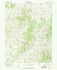
 1961 Cynthiana1962 Print · USGSCynthiana and the surrounding Tri-State area are captured here in the early sixties at a peak of rail and rural development. Genealogists and researchers can trace local family landmarks such as Blythe Chapel, Antioch Ch, and the Knowles Cem burial ground.3 unique versions available
 - 1961 Map of Kasson, 1963 Print
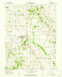
 1961 Kasson1963 Print · USGSThe rural border of Vanderburgh and Posey counties is captured here in the early sixties, showing a landscape of oil production and scattered farming hamlets. Genealogists can locate family landmarks like Parkers Settlement, Engleheim Cem, and the Memorial Cem Ch.2 unique versions available
 - 1962 Map of Belleville
 1962 Belleville1962 Print · USGSSouthern Illinois in the late fifties reveals a landscape of industrial growth and ancient landmarks before the full expansion of the interstate system. Genealogists can trace family names and rural post offices near Centralia, Salem, and the historic Monks Mound.
 - 1964 Map of Paducah
 1964 Paducah1964 Print · USGSThe river-and-rail corridor of Southern Illinois and Western Kentucky is captured here during the height of the mid-century industrial era. Genealogists and researchers can trace local landmarks across several counties, from the rail yards of Paducah to the waters of Crab Orchard Lake and Kentucky Reservoir.2 unique versions available
End of results
Showing maps 1-6 of 6
Top cities of Posey County
- Mount Vernon historical maps
- Poseyville historical maps
- New Harmony historical maps
- Cynthiana historical maps
- Griffin historical maps
Frequently asked questions
- What are the different types of historical maps available for Posey County?
- What is the oldest map of Posey County?
- Where can I purchase historical maps of Posey County for my home or office?
- Where can I download high-res historical maps of Posey County?
- Are there historical topographic maps available for Posey County?
- Is there historical aerial imagery available for Posey County?
- Where are historical maps of Posey County sourced from?