1910s Maps of Posey County, Indiana
Explore 3 historic maps of Posey County from the 1910s. These maps offer a rare glimpse into what life looked like during the 1910s — showing old roads, neighborhoods, homes, and landmarks that have changed or disappeared over time.
Whether you're researching your family's past, planning a metal detecting trip, or studying how Posey County's landscape evolved across the 1910s, these high-resolution maps are a powerful tool for exploring the history of this region.
- Focus on a specific era: All maps on this page are from the 1910s, giving you a focused view of this time period.
- See what’s changed: Compare century-old streets, trails, and buildings to today's modern landscape using overlays and satellite layers.
- Research with precision: Use these maps for genealogy, historical research, land use analysis, or educational projects.
- View, download, or print: Maps are fully viewable online in high resolution, and can be downloaded or printed for your own records.
Start exploring Posey County's history through authentic maps from the 1910s. This is your window into the past.
Posey County, IN maps
(3)- 1914 Map of Henderson
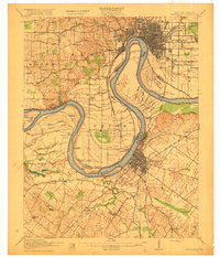
 1914 Henderson1914 Print · USGSThe Ohio River borderlands between Indiana and Kentucky are captured here in the years before the Great War. Genealogists can trace family farms near St Vincents Church or locate long-gone rural schoolhouses like Corkie School and Three Mile School.
 - 1916 Map of Henderson
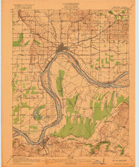
 1916 Henderson1916 Print · USGSThe Ohio River borderlands between Indiana and Kentucky thrived on a mix of river commerce and rail power during the early twentieth century. Genealogists and historians can trace numerous rural districts and schools such as Corkie School, St Vincent, and the riverfront at Mc Donalds Landing.3 unique versions available
 - 1917 Map of Uniontown
 1917 Uniontown1917 Print · USGSThe Ohio River borderlands between Kentucky and Indiana were bustling with river and rail activity during the First World War. Local historians can trace dozens of rural school sites like Bethlehem School and river landmarks such as Slim Island and Hovey Lake.6 unique versions available
End of results
Showing maps 1-3 of 3
Top cities of Posey County
- Mount Vernon historical maps
- Poseyville historical maps
- New Harmony historical maps
- Cynthiana historical maps
- Griffin historical maps
Frequently asked questions
- What are the different types of historical maps available for Posey County?
- What is the oldest map of Posey County?
- Where can I purchase historical maps of Posey County for my home or office?
- Where can I download high-res historical maps of Posey County?
- Are there historical topographic maps available for Posey County?
- Is there historical aerial imagery available for Posey County?
- Where are historical maps of Posey County sourced from?