1980s Maps of Posey County, Indiana
Explore 13 historic maps of Posey County from the 1980s. These maps offer a rare glimpse into what life looked like during the 1980s — showing old roads, neighborhoods, homes, and landmarks that have changed or disappeared over time.
Whether you're researching your family's past, planning a metal detecting trip, or studying how Posey County's landscape evolved across the 1980s, these high-resolution maps are a powerful tool for exploring the history of this region.
- Focus on a specific era: All maps on this page are from the 1980s, giving you a focused view of this time period.
- See what’s changed: Compare century-old streets, trails, and buildings to today's modern landscape using overlays and satellite layers.
- Research with precision: Use these maps for genealogy, historical research, land use analysis, or educational projects.
- View, download, or print: Maps are fully viewable online in high resolution, and can be downloaded or printed for your own records.
Start exploring Posey County's history through authentic maps from the 1980s. This is your window into the past.
Posey County, IN maps
(13)- 1981 Map of Kasson
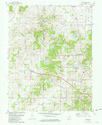 1981 Kasson1981 Print · USGSVanderburgh and Posey Counties appear here in the early eighties as a landscape of rural parish life and active oil production. Genealogists can trace family landmarks like Parkers Settlement, Engleheim Cem, and the old No 6 School.3 unique versions available
 - 1981 Map of West Franklin
 1981 West Franklin1981 Print · USGSThe rural stretches of Posey and Vanderburgh counties meet the Ohio River here in the early eighties. Genealogists and local historians can trace family-named roads and landmarks like St Pauls Ch, Burdette Park, and the riverfront at West Franklin.2 unique versions available
 - 1981 Map of Uniontown
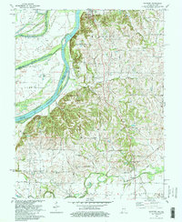
 1981 Uniontown1981 Print · USGSThe riverfront town of Uniontown and its surrounding floodplains are captured here in the early eighties as a landscape of managed wetlands and river industry. Researchers can trace the river's path through Mississippi Bend or locate local landmarks like St Agnes Cem and the Uniontown Locks and Dam.
 - 1981 Map of Wadesville
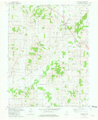 1981 Wadesville1981 Print · USGSPosey County in the early eighties shows a rural landscape transitioning between its agrarian roots and the rise of the energy sector. Researchers can trace family history through Laurel Hill Cem, the South Terrace Sch, and the Louisville and Nashville rail line.
 - 1981 Map of Mount Vernon
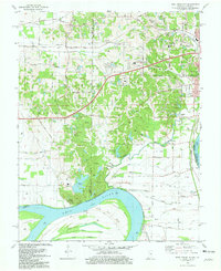
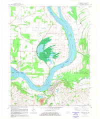
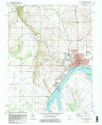 1981 Mount Vernon1981 Print · USGSMount Vernon and the winding Ohio River shoreline appear here in the early eighties, capturing a landscape of active river industry and rural family life. Genealogists can trace sites like Belle Fontaine Cem, Zoar Ch, and the defunct Dead Mans Crossing along the rail lines.
 - 1981 Map of Solitude
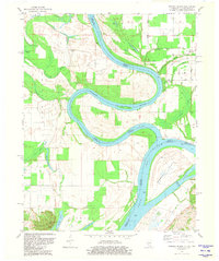
 1981 Solitude1981 Print · USGSThe lower Wabash River valley comes to life in this early 1980s survey, showing the intricate bend of the river and the historic site of New Harmony. Trace rural family history through local landmarks like Bethesda Ch, Savah, and the Alexander Cem near the Illinois border.2 unique versions available
 - 1981 Map of Wabash Island
 1981 Wabash Island1981 Print · USGSThe tri-state borderlands of Illinois, Indiana, and Kentucky are defined by the winding Wabash River and Ohio River in the early eighties. Genealogists and local historians can trace family sites at Oak Grove and Rowe Cem or locate the old Private Ferry crossing.
 - 1982 Map of Mount Vernon
 1982 Mount Vernon1982 Print · USGSSouthern Illinois and Southwestern Indiana meet here during a period of significant regional water management and transit growth. Researchers can trace the development of Rend Lake and locate vanished rail stops along the Southern RR near Bluford and Golden Gate.
 - 1984 Map of West Frankfort, 1985 Print
 1984 West Frankfort1985 Print · USGSSouthern Illinois at the peak of late-century coal and oil production reveals a complex landscape of industry and conservation. Genealogists and historians can trace rail-served mining hubs like Orient No. 3 Mine and the historic riverfront at Old Shawneetown.
 - 1986 Map of Evansville
 1986 Evansville1986 Print · USGSThe Ohio River valley thrives in the mid-1980s as a hub of river commerce, industry, and natural preservation spanning the Indiana-Kentucky border. Genealogists and historians can locate remote landmarks like Dead Mans Cem, Lippe Church, and the riverside community of Scuffletown.
 - 1986 Map of Princeton
 1986 Princeton1986 Print · USGSSouthwestern Indiana is defined by the confluence of the Wabash and White Rivers during the mid-eighties, a period of established rail lines and expanding interstates. Genealogists and historians can trace property locations across numerous townships or locate family sites in Mount Carmel, Poseyville, and Boonville.2 unique versions available
 - 1987 Map of West Frankfort
 1987 West Frankfort1987 Print · USGSSouthern Illinois in the late eighties shows a landscape defined by the coal and river economies. Researchers can trace the extensive Strip Mine works and historic settlements like Shawneetown and Carriers Mills along the Illinois Central Railroad.
 - 1987 Map of Paducah, 1988 Print
 1987 Paducah1988 Print · USGSThe Lower Ohio Valley and the Illinois Ozarks come alive in this late twentieth-century regional survey. Genealogists and local historians can trace river-town roots and state park landmarks from Metropolis to Cape Girardeau and Trail of Tears State Park.
End of results
Showing maps 1-13 of 13
Top cities of Posey County
- Mount Vernon historical maps
- Poseyville historical maps
- New Harmony historical maps
- Cynthiana historical maps
- Griffin historical maps
Frequently asked questions
- What are the different types of historical maps available for Posey County?
- What is the oldest map of Posey County?
- Where can I purchase historical maps of Posey County for my home or office?
- Where can I download high-res historical maps of Posey County?
- Are there historical topographic maps available for Posey County?
- Is there historical aerial imagery available for Posey County?
- Where are historical maps of Posey County sourced from?