1970s Maps of Posey County, Indiana
Explore 3 historic maps of Posey County from the 1970s. These maps offer a rare glimpse into what life looked like during the 1970s — showing old roads, neighborhoods, homes, and landmarks that have changed or disappeared over time.
Whether you're researching your family's past, planning a metal detecting trip, or studying how Posey County's landscape evolved across the 1970s, these high-resolution maps are a powerful tool for exploring the history of this region.
- Focus on a specific era: All maps on this page are from the 1970s, giving you a focused view of this time period.
- See what’s changed: Compare century-old streets, trails, and buildings to today's modern landscape using overlays and satellite layers.
- Research with precision: Use these maps for genealogy, historical research, land use analysis, or educational projects.
- View, download, or print: Maps are fully viewable online in high resolution, and can be downloaded or printed for your own records.
Start exploring Posey County's history through authentic maps from the 1970s. This is your window into the past.
Posey County, IN maps
(3)- 1974 Map of Maunie, 1977 Print
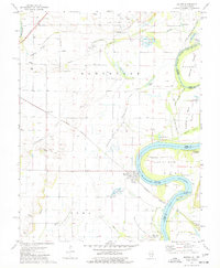 1974 Maunie1977 Print · USGSThe Wabash River borderlands in the mid-seventies reveal a landscape defined by oil extraction and river navigation. Genealogists and local historians can trace family plots like Kuykendall Cem and explore riverside life near Maunie and Rising Sun.
 - 1978 Map of Emma, 1979 Print
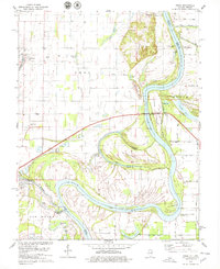 1978 Emma1979 Print · USGSThe river bottomlands of White County and the Illinois-Indiana border are captured here in the late seventies. Researchers can trace local genealogy and river history through landmarks like Emma Concord Ch, Marshall Ferry, and the Dogtown Hills.2 unique versions available
 - 1978 Map of Caborn, 1979 Print
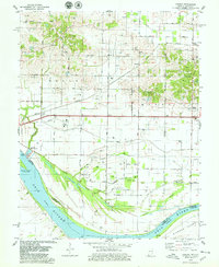 1978 Caborn1979 Print · USGSThe Indiana-Kentucky borderlands along the Ohio River appear here in the late seventies as a landscape of river industry and oil extraction. Trace family roots at St Johns Cem or follow the Louisville and Nashville Railroad through Bufkin and Caborn.2 unique versions available
End of results
Showing maps 1-3 of 3
Top cities of Posey County
- Mount Vernon historical maps
- Poseyville historical maps
- New Harmony historical maps
- Cynthiana historical maps
- Griffin historical maps
Frequently asked questions
- What are the different types of historical maps available for Posey County?
- What is the oldest map of Posey County?
- Where can I purchase historical maps of Posey County for my home or office?
- Where can I download high-res historical maps of Posey County?
- Are there historical topographic maps available for Posey County?
- Is there historical aerial imagery available for Posey County?
- Where are historical maps of Posey County sourced from?