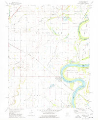
1974 Map of Maunie
USGS Topo · Published 1977About this map
The Wabash River carves a complex, winding course along the Illinois and Indiana border, creating prominent landmarks like Aldrich Bend and Ri Beyre Island. This mid-1970s landscape is defined by the extraction economy of the Phillipstown Oil Field and the Maunie North Oil Field, which are interspersed with numerous family cemeteries such as Kuykendall Cem and Cleveland Cem. The settlement of Maunie serves as a focal point near the river, while the Louisville and Nashville railroad provides a critical transit link across the fertile bottomlands. Local history is etched into the terrain through features like the Aldrich Mound and the narrow waters of The Chute, illustrating a river-dependent community where levee systems like the Wabash Levee protect small clusters of homes at Rising Sun and Epworth.
Find a feature on this map
68 named features on this map. Tap any name to fly to it.
Don’t see what you’re looking for? This feature index may not catch every label — zoom into the map to look around manually.
Map Details
Editions of this 1974 Maunie Map
This is the sole edition of this map. No revisions or reprints were ever made.
Other maps of this area

1903 · New Harmony
USGS Topo · 1:62,500

1903 · Patoka
USGS Topo · 1:125,000

1905 · New Haven
USGS Topo · 1:62,500

1906 · New Haven
USGS Topo · 1:62,500

1917 · Uniontown
USGS Topo · 1:62,500

1938 · New Harmony
USGS Topo · 1:62,500

1940 · Carmi
USGS Topo · 1:62,500

1943 · Carmi
USGS Topo · 1:62,500

1949 · Paducah
USGS Topo · 1:250,000

1949 · New Haven
USGS Topo · 1:62,500