1960s Maps of Farmersburg, Indiana
Explore 4 historic maps of Farmersburg from the 1960s. These maps offer a rare glimpse into what life looked like during the 1960s — showing old roads, neighborhoods, homes, and landmarks that have changed or disappeared over time.
Whether you're researching your family's past, planning a metal detecting trip, or studying how Farmersburg's landscape evolved across the 1960s, these high-resolution maps are a powerful tool for exploring the history of this region.
- Focus on a specific era: All maps on this page are from the 1960s, giving you a focused view of this time period.
- See what’s changed: Compare century-old streets, trails, and buildings to today's modern landscape using overlays and satellite layers.
- Research with precision: Use these maps for genealogy, historical research, land use analysis, or educational projects.
- View, download, or print: Maps are fully viewable online in high resolution, and can be downloaded or printed for your own records.
Start exploring Farmersburg's history through authentic maps from the 1960s. This is your window into the past.
Farmersburg, IN maps
(4)- 1962 Map of Indianapolis
 1962 Indianapolis1962 Print · USGSCentral Indiana and the Illinois borderlands are captured here in the early sixties, showing the region's dense rail networks and growing urban centers. Genealogists and historians can locate family-named landmarks and institutions like Crown Hill Cem, Indiana University, and the Indianapolis Motor Speedway.
 - 1963 Map of Shelburn, 1964 Print
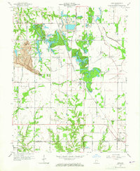
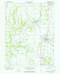 1963 Shelburn1964 Print · USGSSullivan County during the 1960s reveals a landscape of coal and oil production alongside established farming communities. Genealogists and historians can trace the foundations of Shelburn and Farmersburg, locating landmarks like West Lawn Cem and the Chicago and Eastern Illinois Railroad.4 unique versions available
 - 1963 Map of Lewis, 1965 Print
 1963 Lewis1965 Print · USGSThe Vigo and Sullivan County line near Lewis shows a landscape defined by coal and transit in the mid-1960s. Genealogists and historians can trace the Wabash and Erie Canal route, old schools, and country churches like Fletcher Chapel and Union Ch.3 unique versions available
 - 1963 Map of Hymera, 1965 Print
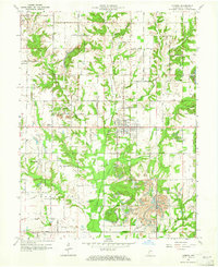 1963 Hymera1965 Print · USGSSullivan County during the 1960s shows a landscape of active extraction and established rural settlements like Hymera and Miner City. Researchers can trace the path of the CHICAGO MILWAUKEE ST PAUL AND PACIFIC RAILROAD or locate local landmarks like Oak Grove Ch and the Knights of Columbus Cem.3 unique versions available
End of results
Showing maps 1-4 of 4
Top cities near Farmersburg
- Terre Haute historical maps
- Linton historical maps
- Sullivan historical maps
- Jasonville historical maps
- West Terre Haute historical maps
- Cass historical maps
See more
Frequently asked questions
- What are the different types of historical maps available for Farmersburg?
- What is the oldest map of Farmersburg?
- Where can I purchase historical maps of Farmersburg for my home or office?
- Where can I download high-res historical maps of Farmersburg?
- Are there historical topographic maps available for Farmersburg?
- Is there historical aerial imagery available for Farmersburg?
- Where are historical maps of Farmersburg sourced from?