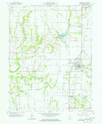
1963 Map of Shelburn
USGS Topo · Published 1964About this map
Shelburn and its outlying neighborhoods of Curryville and East Shelburn anchor this 1963 survey of Sullivan County. The landscape is defined by the heavy footprint of the local extractive economy, showing numerous Oil Wells and the Thunderbird Railroad Grade leading to Thunderbird Pond. In the north, Farmersburg sits along the Chicago and Eastern Illinois Railroad, while smaller rural hubs like Scott City and Miner City mark the surrounding township sections. The map serves as a detailed record of the area's social history, locating numerous rural congregations and burying grounds, including Ebenezer Ch, Pleasant Green Cem, and West Lawn Cem. The terrain is deeply incised by the drainage basins of Turman Creek and Sugar Creek, illustrating the intersection of natural hydrology and industrial activity in mid-century Indiana.
Find a feature on this map
48 named features on this map. Tap any name to fly to it.
Don’t see what you’re looking for? This feature index may not catch every label — zoom into the map to look around manually.
Map Details
Editions of this 1963 Shelburn Map
4 editions found
Other maps of this area

1932 · Marshall
USGS Topo · 1:62,500

1937 · Marshall
USGS Topo · 1:62,500

1940 · Lewis
USGS Topo · 1:24,000

1940 · Pimento
USGS Topo · 1:24,000

1942 · Fairbanks
USGS Topo · 1:24,000

1942 · Shelburn
USGS Topo · 1:24,000

1942 · Hutton
USGS Topo · 1:24,000

1943 · Merom
USGS Topo · 1:24,000

1943 · Hymera
USGS Topo · 1:24,000

1943 · Sullivan
USGS Topo · 1:24,000