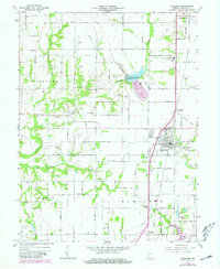
1963 Map of Shelburn
USGS Topo · Published 1981About this map
Shelburn and Farmersburg anchor this 1960s study of Sullivan County, where the landscape is defined by a dense network of country roads and the industrious path of the Louisville and Nashville railroad. The map reflects a rural community deeply tied to its land and history, evidenced by the numerous cemeteries such as West Lawn Cem, Ebenezer Cem, and Chowning Cem. In the central region, the Thunderbird Pond and various tailings ponds indicate the local mining operations, including a specific Mine location near Curry. Small residential clusters like Curryville, Standard, and Scott City are scattered throughout the townships of Fairbanks, Turman, and Hamilton. Notable educational and religious landmarks, including the North Central High Sch and Liberty Ch, provide vital points of reference for genealogists tracing family footprints through these Indiana townships during the mid-twentieth century.
Find a feature on this map
44 named features on this map. Tap any name to fly to it.
Don’t see what you’re looking for? This feature index may not catch every label — zoom into the map to look around manually.
Map Details
Editions of this 1963 Shelburn Map
4 editions found
Other maps of this area

1932 · Marshall
USGS Topo · 1:62,500

1937 · Marshall
USGS Topo · 1:62,500

1940 · Lewis
USGS Topo · 1:24,000

1940 · Pimento
USGS Topo · 1:24,000

1942 · Fairbanks
USGS Topo · 1:24,000

1942 · Shelburn
USGS Topo · 1:24,000

1942 · Hutton
USGS Topo · 1:24,000

1943 · Merom
USGS Topo · 1:24,000

1943 · Hymera
USGS Topo · 1:24,000

1943 · Sullivan
USGS Topo · 1:24,000