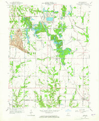
1963 Map of Lewis
USGS Topo · Published 1965About this map
The boundary between Vigo and Sullivan Counties defines this landscape of mid-century industrial transition, where remnants of the 19th-century Wabash and Erie Canal run parallel to modern operations. North of Lewis, the land is marked by an extensive Strip Mine area, complete with a Tipple and several man-made water bodies such as Wonder Lake and Paint Mill Lake that fill the former excavations. These heavy industrial footprints contrast with established farming communities like Blackhawk and the curiously named Brown Jug Corner.
Find a feature on this map
43 named features on this map. Tap any name to fly to it.
Don’t see what you’re looking for? This feature index may not catch every label — zoom into the map to look around manually.
Map Details
Editions of this 1963 Lewis Map
3 editions found
Other maps of this area

1908 · Clay City
USGS Topo · 1:48,000

1910 · Clay City
USGS Topo · 1:62,500

1940 · Lewis
USGS Topo · 1:24,000

1940 · Jasonville
USGS Topo · 1:24,000

1940 · Pimento
USGS Topo · 1:24,000

1941 · Seelyville
USGS Topo · 1:24,000

1941 · Terre Haute
USGS Topo · 1:24,000

1942 · Shelburn
USGS Topo · 1:24,000

1943 · Hymera
USGS Topo · 1:24,000

1948 · Terre Haute
USGS Topo · 1:24,000