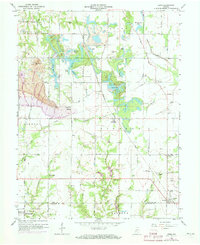
1963 Map of Lewis
USGS Topo · Published 1973About this map
Industrial and agricultural landscapes intersect in this detailed view of the Vigo and Sullivan County border. The map documents the extensive presence of strip mining operations, particularly around Sanford Hill and the Keller area, which transformed the local topography. This resource extraction economy is contrasted by the lingering infrastructure of a previous era, notably the path of the Wabash and Erie Canal passing through Riley in the northeast. Small rural settlements like Blackhawk and Lewis serve as social anchors, each supported by numerous family cemeteries and local congregations such as Shady Grove Church and Fletcher Chapel. A network of water bodies, including Lee Lake and French Lake, are scattered across the terrain, reflecting the environmental changes brought about by both natural drainage and mining-related excavations near Splunge Creek.
Find a feature on this map
52 named features on this map. Tap any name to fly to it.
Don’t see what you’re looking for? This feature index may not catch every label — zoom into the map to look around manually.
Map Details
Editions of this 1963 Lewis Map
3 editions found
Other maps of this area

1908 · Clay City
USGS Topo · 1:48,000

1910 · Clay City
USGS Topo · 1:62,500

1940 · Lewis
USGS Topo · 1:24,000

1940 · Jasonville
USGS Topo · 1:24,000

1940 · Pimento
USGS Topo · 1:24,000

1941 · Seelyville
USGS Topo · 1:24,000

1941 · Terre Haute
USGS Topo · 1:24,000

1942 · Shelburn
USGS Topo · 1:24,000

1943 · Hymera
USGS Topo · 1:24,000

1948 · Terre Haute
USGS Topo · 1:24,000