1960s Maps of Lafayette, Indiana
Explore 4 historic maps of Lafayette from the 1960s. These maps offer a rare glimpse into what life looked like during the 1960s — showing old roads, neighborhoods, homes, and landmarks that have changed or disappeared over time.
Whether you're researching your family's past, planning a metal detecting trip, or studying how Lafayette's landscape evolved across the 1960s, these high-resolution maps are a powerful tool for exploring the history of this region.
- Focus on a specific era: All maps on this page are from the 1960s, giving you a focused view of this time period.
- See what’s changed: Compare century-old streets, trails, and buildings to today's modern landscape using overlays and satellite layers.
- Research with precision: Use these maps for genealogy, historical research, land use analysis, or educational projects.
- View, download, or print: Maps are fully viewable online in high resolution, and can be downloaded or printed for your own records.
Start exploring Lafayette's history through authentic maps from the 1960s. This is your window into the past.
Lafayette, IN maps
(4)- 1961 Map of Romney, 1962 Print
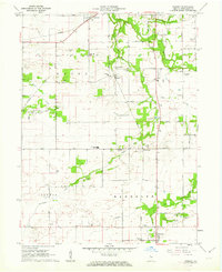 1961 Romney1962 Print · USGSTippecanoe County farmland is captured here in the early sixties, showing the vital link between rural crossroads and the rail line. Genealogists can locate family landmarks like Elmwood Cem, Stidham Ch, and the settlement of South Raub along the Monon railroad.2 unique versions available
 - 1961 Map of Stockwell, 1962 Print
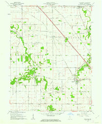 1961 Stockwell1962 Print · USGSTippecanoe County agriculture and rail transit intersect in the early sixties, showing the small-town life of Stockwell and Dayton. Genealogists can trace early family sites through landmarks like Township High Sch, St Joe Cem, and Gladens Corner.2 unique versions available
 - 1961 Map of Lafayette East, 1962 Print
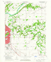 1961 Lafayette East1962 Print · USGSLafayette's eastern edge and the Wabash River valley are captured here just as mid-century suburban expansion reached into the surrounding townships. Genealogists and local researchers can trace long-standing landmarks like St Boniface Cemetery, Cary Camp, and the rail junction at Altamont Switch.5 unique versions available
 - 1961 Map of Lafayette West, 1964 Print
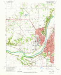 1961 Lafayette West1964 Print · USGSGreater Lafayette was evolving rapidly in the early sixties as university expansion and new residential additions transformed the river valley. Researchers can trace historic institutional sites like the Soldiers Home, the Ouiatenon Blockhouse, and the sprawling grounds of Purdue University.6 unique versions available
End of results
Showing maps 1-4 of 4
Top cities near Lafayette
- West Lafayette historical maps
- Delphi historical maps
- Shadeland historical maps
- Brookston historical maps
- Mulberry historical maps
- Battle Ground historical maps
See more
Top neighborhoods of Lafayette
- Norma Jean Addition historical maps
- Elston historical maps
- Altamont Switch historical maps
- Eastwich historical maps
- Tecumseh historical maps
- Edgelea historical maps
See more
Frequently asked questions
- What are the different types of historical maps available for Lafayette?
- What is the oldest map of Lafayette?
- Where can I purchase historical maps of Lafayette for my home or office?
- Where can I download high-res historical maps of Lafayette?
- Are there historical topographic maps available for Lafayette?
- Is there historical aerial imagery available for Lafayette?
- Where are historical maps of Lafayette sourced from?