1960s Maps of Sun City, Kansas
Explore 2 historic maps of Sun City from the 1960s. These maps offer a rare glimpse into what life looked like during the 1960s — showing old roads, neighborhoods, homes, and landmarks that have changed or disappeared over time.
Whether you're researching your family's past, planning a metal detecting trip, or studying how Sun City's landscape evolved across the 1960s, these high-resolution maps are a powerful tool for exploring the history of this region.
- Focus on a specific era: All maps on this page are from the 1960s, giving you a focused view of this time period.
- See what’s changed: Compare century-old streets, trails, and buildings to today's modern landscape using overlays and satellite layers.
- Research with precision: Use these maps for genealogy, historical research, land use analysis, or educational projects.
- View, download, or print: Maps are fully viewable online in high resolution, and can be downloaded or printed for your own records.
Start exploring Sun City's history through authentic maps from the 1960s. This is your window into the past.
Sun City, KS maps
(2)- 1968 Map of Sun City SW, 1969 Print
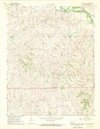 1968 Sun City SW1969 Print · USGSBarber County’s energy and rail landscape is caught in detail during the late sixties, highlighting the intersection of the Medicine Lodge River and industrial growth. Researchers can trace the Atchison Topeka and Santa Fe rail line alongside the Sun City Oil and Gas Field and landmarks like Memorial Bridge.2 unique versions available
 - 1968 Map of Sun City, 1969 Print
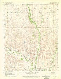 1968 Sun City1969 Print · USGSSun City and the Barber County cattle country are captured in the late sixties as the local economy balanced rail transport with a growing energy sector. Genealogists and researchers can trace the Medicine Lodge River and find Chinn Cem, Sunnyside Cem, and the Sun City Oil Field.
End of results
Showing maps 1-2 of 2
Top cities near Sun City
Frequently asked questions
- What are the different types of historical maps available for Sun City?
- What is the oldest map of Sun City?
- Where can I purchase historical maps of Sun City for my home or office?
- Where can I download high-res historical maps of Sun City?
- Are there historical topographic maps available for Sun City?
- Is there historical aerial imagery available for Sun City?
- Where are historical maps of Sun City sourced from?