1960s Maps of Bourbon County, Kansas
Explore 8 historic maps of Bourbon County from the 1960s. These maps offer a rare glimpse into what life looked like during the 1960s — showing old roads, neighborhoods, homes, and landmarks that have changed or disappeared over time.
Whether you're researching your family's past, planning a metal detecting trip, or studying how Bourbon County's landscape evolved across the 1960s, these high-resolution maps are a powerful tool for exploring the history of this region.
- Focus on a specific era: All maps on this page are from the 1960s, giving you a focused view of this time period.
- See what’s changed: Compare century-old streets, trails, and buildings to today's modern landscape using overlays and satellite layers.
- Research with precision: Use these maps for genealogy, historical research, land use analysis, or educational projects.
- View, download, or print: Maps are fully viewable online in high resolution, and can be downloaded or printed for your own records.
Start exploring Bourbon County's history through authentic maps from the 1960s. This is your window into the past.
Bourbon County, KS maps
(8)- 1961 Map of Lawrence
 1961 Lawrence1961 Print · USGSThe Kansas-Missouri borderland shows its mid-century transition from a rail-dependent agricultural region to a suburbanizing landscape. Genealogists can trace family footprints through numerous Cem sites and distinctive terrain landmarks like Graves Mound and Summers Mound.
 - 1964 Map of Hiattville, 1965 Print
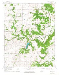
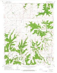
 1964 Hiattville1965 Print · USGSBourbon and Crawford counties are shown here in the mid-1960s, a landscape shaped by rail lines and the winding tributaries of the Pawnee. Researchers can locate the Fairview School, the Farlington Cem, and the specialized Fish Hatchery near Farlington Lake.
 - 1966 Map of Moran SE, 1967 Print
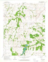
 1966 Moran SE1967 Print · USGSBourbon County rural life in the mid-1960s is centered on the Marmaton River and the emerging recreation at Bourbon County State Park. Trace family history at Mason Cem or follow the path of the Old Railroad Grade.
 - 1966 Map of Xenia, 1967 Print
 1966 Xenia1967 Print · USGSBourbon County is captured in the mid-1960s as a region of active resource extraction and quiet rural crossroads. Researchers can locate the ancestral burial grounds at Walnut Hill Cem, the church at Dry Ridge Ch, and the old community at Berlin.
 - 1966 Map of Bronson, 1967 Print
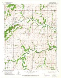
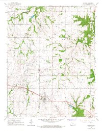 1966 Bronson1967 Print · USGSThe rural border of Allen and Bourbon counties is captured in the mid-1960s, showing the intersection of local industry and railroad history. Researchers can trace the Missouri Pacific line through Bronson or locate ancestral sites like South Osage Cem and Ensminger Cem.
 - 1966 Map of Mapleton, 1967 Print
 1966 Mapleton1967 Print · USGSThe rural borderlands of Linn and Bourbon counties are captured here in the mid-1960s, centered on the settlement of Mapleton. Researchers can trace the path of an Old Railroad Grade or locate family history at Stevenson Cem and Campbell Cem.
 - 1966 Map of Blue Mound, 1967 Print
 1966 Blue Mound1967 Print · USGSThe rural landscape of Linn and Anderson counties comes into focus in the mid-1960s, centered on the town of Blue Mound. Genealogists and historians can trace an Old Railroad Grade and several burial sites like Osage Cem and Boulware Cem.
 - 1966 Map of Uniontown, 1967 Print
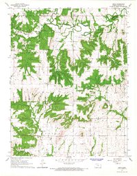
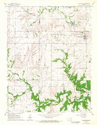
 1966 Uniontown1967 Print · USGSSoutheast Kansas in the mid-sixties reveals a landscape shaped by the Marmaton River and early frontier history. Genealogists and historians can trace family roots at Mt Zion Cem, locate the Old Indian Treaty Boundary, or find the former Old Railroad Grade near Uniontown.
End of results
Showing maps 1-8 of 8
Top cities of Bourbon County
- Fort Scott historical maps
- Marmaton historical maps
- Bronson historical maps
- Uniontown historical maps
- Fulton historical maps
- Redfield historical maps
See more
Frequently asked questions
- What are the different types of historical maps available for Bourbon County?
- What is the oldest map of Bourbon County?
- Where can I purchase historical maps of Bourbon County for my home or office?
- Where can I download high-res historical maps of Bourbon County?
- Are there historical topographic maps available for Bourbon County?
- Is there historical aerial imagery available for Bourbon County?
- Where are historical maps of Bourbon County sourced from?