1990s Maps of Bourbon County, Kansas
Explore 7 historic maps of Bourbon County from the 1990s. These maps offer a rare glimpse into what life looked like during the 1990s — showing old roads, neighborhoods, homes, and landmarks that have changed or disappeared over time.
Whether you're researching your family's past, planning a metal detecting trip, or studying how Bourbon County's landscape evolved across the 1990s, these high-resolution maps are a powerful tool for exploring the history of this region.
- Focus on a specific era: All maps on this page are from the 1990s, giving you a focused view of this time period.
- See what’s changed: Compare century-old streets, trails, and buildings to today's modern landscape using overlays and satellite layers.
- Research with precision: Use these maps for genealogy, historical research, land use analysis, or educational projects.
- View, download, or print: Maps are fully viewable online in high resolution, and can be downloaded or printed for your own records.
Start exploring Bourbon County's history through authentic maps from the 1990s. This is your window into the past.
Bourbon County, KS maps
(7)- 1990 Map of Chanute
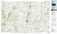 1990 Chanute1990 Print · USGSSoutheast Kansas at the start of the nineties reveals a landscape of river-valley towns and agricultural hubs. Researchers can trace the paths of the Missouri Pacific RR through Iola or locate family roots near Savonburg, Thayer, and Buffalo.
 - 1990 Map of Garnett
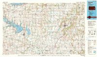 1990 Garnett1990 Print · USGSEast-central Kansas was a landscape of major reservoirs and established rail towns during the 1990s. Genealogists and historians can trace the paths of the Missouri Pacific Railroad and the Atchison Topeka and Santa Fe Railway through towns like Garnett and Silkville.
 - 1991 Map of Hume
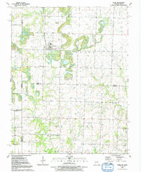 1991 Hume1991 Print · USGSThe Missouri-Kansas border area near Hume is captured here during the late twentieth century, showing a landscape defined by state-line boundaries and rural heritage. Researchers can locate family sites and landmarks like Lawrence Cem, Amos, and Rocky Mound.
 - 1991 Map of Deerfield
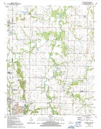
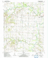 1991 Deerfield1991 Print · USGSThe Missouri-Kansas borderlands in the early 1990s show a landscape of rural townships and active extraction. Genealogists and researchers can trace family landmarks like Logan Cem and Clayton Ch or follow the path of the Marmaton River past Eve.
 - 1991 Map of Richards
 1991 Richards1991 Print · USGSVernon County and the Kansas borderlands appear in detail in the early nineties, showing a landscape defined by the Little Osage River. Researchers can trace the path of the Old Railroad Grade or locate family plots at Richland Cem and East Liberty Cem.
 - 1991 Map of Garland
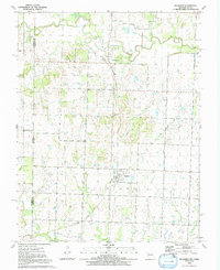
 1991 Garland1991 Print · USGSThe Kansas-Missouri border comes alive in the early nineties, showcasing the rural landscapes of Bourbon and Crawford Counties. Genealogists can locate several historic burial sites like Davis Cem and Shiloh Cem, or trace the path of Dry Wood Creek past the town of Arcadia.
 - 1991 Map of Nevada
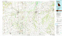 1991 Nevada1991 Print · USGSThis borderland region in the early nineties captures the transition from Kansas plains to Missouri timber. Researchers can trace family history through Bunn Cemetery, locate the Camp Clark Military Reservation, and explore rail towns like Nevada and Fort Scott.
End of results
Showing maps 1-7 of 7
Top cities of Bourbon County
- Fort Scott historical maps
- Marmaton historical maps
- Bronson historical maps
- Uniontown historical maps
- Fulton historical maps
- Redfield historical maps
See more
Frequently asked questions
- What are the different types of historical maps available for Bourbon County?
- What is the oldest map of Bourbon County?
- Where can I purchase historical maps of Bourbon County for my home or office?
- Where can I download high-res historical maps of Bourbon County?
- Are there historical topographic maps available for Bourbon County?
- Is there historical aerial imagery available for Bourbon County?
- Where are historical maps of Bourbon County sourced from?