1900s (20th Century) Maps of Labette County, Kansas
Explore 51 historic maps of Labette County from the 1900s (20th Century). These maps offer a rare glimpse into what life looked like during the 1900s — showing old roads, neighborhoods, homes, and landmarks that have changed or disappeared over time.
Whether you're researching your family's past, planning a metal detecting trip, or studying how Labette County's landscape evolved across the 1900s, these high-resolution maps are a powerful tool for exploring the history of this region.
- Focus on a specific era: All maps on this page are from the 1900s, giving you a focused view of this time period.
- See what’s changed: Compare century-old streets, trails, and buildings to today's modern landscape using overlays and satellite layers.
- Research with precision: Use these maps for genealogy, historical research, land use analysis, or educational projects.
- View, download, or print: Maps are fully viewable online in high resolution, and can be downloaded or printed for your own records.
Start exploring Labette County's history through authentic maps from the 1900s. This is your window into the past.
Labette County, KS maps
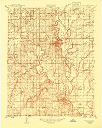
(51)- 1901 Map of Nowata
 1901 Nowata1901 Print · USGSThe Cherokee Nation in Indian Territory is captured here at the start of the twentieth century, showing the lands that would soon become northeast Oklahoma. Researchers can trace early rail-town growth in Nowata and Bartlesville or locate smaller settlements like Alluwe and Coodys Bluff.2 unique versions available
 - 1901 Map of Vinita
 1901 Vinita1901 Print · USGSIndian Territory at the turn of the century shows a landscape of burgeoning railroad towns and Cherokee Nation settlements. Genealogists can trace family roots in early townsites like Vinita, Bluejacket, and Chelsea or locate rural homesteads near Cabin Creek.2 unique versions available
 - 1905 Map of Independence
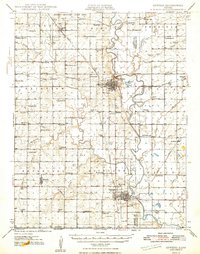
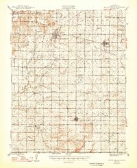
 1905 Independence1905 Print · USGSSoutheastern Kansas at the turn of the century is a landscape of expanding rail-hubs and river commerce. Genealogists can trace early homesteads and rail-stops like Lafontaine, Havana, and Sycamore, or locate family landmarks near Table Mound and the Verdigris River.4 unique versions available
 - 1913 Map of Vinita
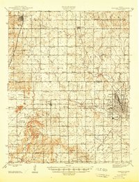
 1913 Vinita1913 Print · USGSNortheast Oklahoma at the height of its rail-and-ranch era is meticulously detailed here just as the state was entering its second decade. Genealogists can trace family roots through dozens of local landmarks like W H School, Big Cabin, and the Blue Hawk School.3 unique versions available
 - 1914 Map of Nowata
 1914 Nowata1914 Print · USGSNortheastern Oklahoma at the height of its early statehood growth is documented here as the railroad network expanded across the Verdigris River valley. Genealogists can locate dozens of country schools like Go-back School and vanished post offices such as Avelia Wayside PO.5 unique versions available
 - 1943 Map of McCune, 1968 Print
 1943 McCune1968 Print · USGSSoutheast Kansas at the height of the Second World War reveals a landscape where traditional farming meets heavy military industry. Researchers can trace the massive Kansas Ordnance Plant alongside vanished rural school districts like Stone Palace Sch and Ideat Sch.
 - 1944 Map of Oswego, 1970 Print
 1944 Oswego1970 Print · USGSSoutheast Kansas during the mid-forties reveals a landscape defined by the Neosho River and a dense network of railroad towns. Genealogists and historians can trace dozens of country schools like Mosquito Valley Sch and Eclipse Sch, as well as the footprint of the Kansas Ordnance Plant Area.
 - 1945 Map of Mc Cune
 1945 Mc Cune1945 Print · USGSSoutheastern Kansas at the close of the Second World War shows a landscape of river-bottom farms and emerging industry. Genealogists can locate dozens of country schools like Quick Sch and trace family ties at the Franklin Cem or Oakwood Cem.2 unique versions available
 - 1945 Map of Parsons, 1956 Print
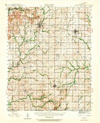
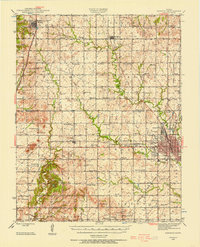 1945 Parsons1956 Print · USGSSoutheastern Kansas at the end of World War II reveals a landscape of thriving rail hubs and vanishing rural hamlets. Researchers can trace the legacy of school districts like New Hope Sch, the grounds of the State Asylum, and the location of the Site of Wilsonton.
 - 1946 Map of Oswego
 1946 Oswego1946 Print · USGSSoutheastern Kansas at the end of the war reveals a landscape of river-bottom farming, active coal extraction, and defense-era industrial expansion. Genealogists can trace family roots through numerous rural sites like Friendship Sch, Pleasant Valley Cem, and the town of Bartlett.
 - 1946 Map of Parsons
 1946 Parsons1946 Print · USGSSoutheast Kansas at the close of the 1940s reveals a landscape defined by busy rail hubs and a dense network of one-room schoolhouses. Genealogists can trace family names through dozens of rural sites like Sylvandale Sch, Mt Calvary Cem, and the State Asylum at Parsons.
 - 1946 Map of Mound Valley, 1965 Print
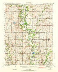
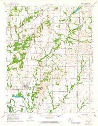
 1946 Mound Valley1965 Print · USGSLabette County's rural townships are documented here just after the war, showing a landscape defined by small-town rail junctions and an abundance of country schools. Genealogists can locate family landmarks like Hopewell Cem, Union Ch, and dozens of rural schools from Blackford Sch to Hiatt Sch.
 - 1947 Map of Parsons
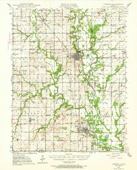
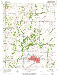
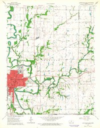
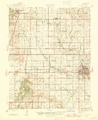 1947 Parsons1947 Print · USGSParsons and the surrounding Labette County plains are caught here in the mid-1940s, a time of heavy rail traffic and established rural townships. Genealogists can trace family roots through numerous small landmarks like Mt Calvary Cem, Shiloh Sch, and the Site of Wilsonton.2 unique versions available
 - 1947 Map of Joplin, 1954 Print
 1947 Joplin1954 Print · USGSThe borderlands of Missouri, Kansas, and Oklahoma are shown here during the late 1940s, a period of heavy industrial and military activity. Researchers can trace the extensive Tri-State Mining District, the layout of Camp Crowder, and local landmarks like Mount Hope Cem.
 - 1948 Map of Oswego
 1948 Oswego1948 Print · USGSSoutheast Kansas in the late 1940s reveals a landscape defined by the Neosho River and a bustling extractive economy. Researchers can trace dozens of rural school sites like Shiloh Sch and Liggett Sch, alongside numerous strip mines and family cemeteries.3 unique versions available
 - 1948 Map of Mound Valley
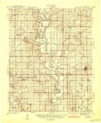
 1948 Mound Valley1948 Print · USGSLabette County underwent a period of stable agrarian growth in the late 1940s, anchored by bustling rail towns and a grid of rural schoolhouses. Genealogists can locate family landmarks like Hopewell Cem, the U S Auxiliary Landing Field, and the M K T railroad line.2 unique versions available
 - 1949 Map of Joplin
 1949 Joplin1949 Print · USGSThe Kansas-Missouri borderlands thrive in the late 1940s, showing a robust network of railroad towns and river valleys. Researchers can trace historic rail lines like the Missouri Pacific RR and locate rural centers such as Chanute, Iola, and Fort Scott.
 - 1954 Map of Tulsa
 1954 Tulsa1954 Print · USGSNortheast Oklahoma and the Ozark border are shown here during a period of massive industrial and infrastructure growth. Researchers can trace the legacy of the Tri-State Mining District and the development of major reservoirs like Grand Lake O' The Cherokees.2 unique versions available
 - 1954 Map of Joplin, 1967 Print
 1954 Joplin1967 Print · USGSThe tri-state border region of Kansas, Missouri, and Oklahoma is captured here during a peak era of mid-century industrial and agricultural activity. Researchers can trace family history through dozens of rural cemeteries or locate landmarks like the Kansas Army Ammunition Plant and Pittsburg State University.3 unique versions available
 - 1958 Map of Joplin
 1958 Joplin1958 Print · USGSThe tri-state border region of Missouri, Kansas, and Oklahoma is shown during the late fifties, a time of heavy rail traffic and mining activity. Local historians can trace the industrial landscape through the Joplin & Pittsburg Ry or locate family sites like Zion Ch and Bender Mounds.
 - 1958 Map of Tulsa, 1968 Print
 1958 Tulsa1968 Print · USGSNortheast Oklahoma and the Ozark borderlands are captured here during a massive era of reservoir construction and highway expansion. Researchers can trace the mid-century footprints of Tulsa, the sprawling Lake O' the Cherokees, and historical sites like Pea Ridge National Military Park.3 unique versions available
 - 1959 Map of Joplin
 1959 Joplin1959 Print · USGSThe Tri-State region’s mining and rail-driven economy is on full display in the late fifties. Genealogists can locate Lead and Zinc Mines near Joplin, family markers at Oak Hill Cem, and military history at Camp Clark.
 - 1962 Map of Liberty, 1964 Print
 1962 Liberty1964 Print · USGSIn the early sixties, the town of Liberty was a vital stop along the Atchison Topeka and Santa Fe railroad corridor. Family historians can trace local roots through the Old Indian Treaty Boundary and landmarks like Billings Sch and Harmony Cem.2 unique versions available
 - 1962 Map of Cherryvale, 1964 Print
 1962 Cherryvale1964 Print · USGSSoutheast Kansas in the early sixties is defined by the busy rail junction at Cherryvale and the surrounding oil and shale works. Researchers can trace the Old Indian Treaty Boundary or locate family roots at Hiltz Cem and Pleasant Dale Sch.2 unique versions available
 - 1962 Map of Coffeyville East, 1964 Print
 1962 Coffeyville East1964 Print · USGSCoffeyville and its surrounding townships show a thriving mid-century mix of oil production and local education just north of the Oklahoma border. Researchers can trace the OLD INDIAN TREATY BOUNDARY or locate family roots at Elmwood Cemetery and Walter Johnson Sch.2 unique versions available
Showing maps 1-25 of 51
Top cities of Labette County
- Parsons historical maps
- Oswego historical maps
- Chetopa historical maps
- Altamont historical maps
- Edna historical maps
- Mound Valley historical maps
See more
Frequently asked questions
- What are the different types of historical maps available for Labette County?
- What is the oldest map of Labette County?
- Where can I purchase historical maps of Labette County for my home or office?
- Where can I download high-res historical maps of Labette County?
- Are there historical topographic maps available for Labette County?
- Is there historical aerial imagery available for Labette County?
- Where are historical maps of Labette County sourced from?