1900s (20th Century) Maps of Lyon County, Kansas
Explore 32 historic maps of Lyon County from the 1900s (20th Century). These maps offer a rare glimpse into what life looked like during the 1900s — showing old roads, neighborhoods, homes, and landmarks that have changed or disappeared over time.
Whether you're researching your family's past, planning a metal detecting trip, or studying how Lyon County's landscape evolved across the 1900s, these high-resolution maps are a powerful tool for exploring the history of this region.
- Focus on a specific era: All maps on this page are from the 1900s, giving you a focused view of this time period.
- See what’s changed: Compare century-old streets, trails, and buildings to today's modern landscape using overlays and satellite layers.
- Research with precision: Use these maps for genealogy, historical research, land use analysis, or educational projects.
- View, download, or print: Maps are fully viewable online in high resolution, and can be downloaded or printed for your own records.
Start exploring Lyon County's history through authentic maps from the 1900s. This is your window into the past.
Lyon County, KS maps
(32)- 1947 Map of Lawrence, 1954 Print
 1947 Lawrence1954 Print · USGSEastern Kansas and western Missouri thrive in the late 1940s, showing a landscape defined by major river valleys and a dense railway network. Genealogists can trace family settlements from Lawrence to Greenwood and locate landmarks like Olathe Navy and Lake Lotawana.
 - 1950 Map of Lawrence
 1950 Lawrence1950 Print · USGSMid-century Kansas and Missouri come alive in this map of the river-valley corridors just as the interstate era was beginning. Researchers can trace the legacy of major rail lines like the Union Pacific RR and locate ancestral roots in towns from Lawrence to Harrisonville.
 - 1955 Map of Hutchinson, 1967 Print
 1955 Hutchinson1967 Print · USGSCentral Kansas in the mid-sixties reveals a landscape of growing reservoirs and evolving transportation corridors. Trace the development of towns like Hutchinson and Abilene alongside the Union Pacific Railroad and the expanding Interstate 70.3 unique versions available
 - 1956 Map of Lawrence, 1967 Print
 1956 Lawrence1967 Print · USGSEastern Kansas and the Missouri border country are captured here during the mid-century transition to the interstate era. Genealogists and local historians can trace family-named terrain like Summers Mound and the footprint of Sunflower Ordnance Works near Baldwin City.4 unique versions available
 - 1957 Map of Lang, 1958 Print
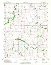
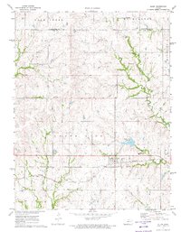
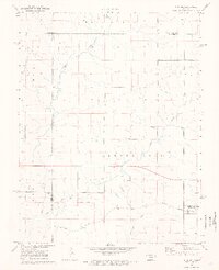
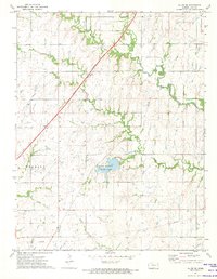
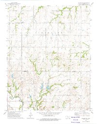
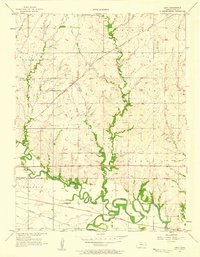 1957 Lang1958 Print · USGSLyon County in the late 1950s is defined by the winding Neosho and Cottonwood Rivers and the vital transit lines of the Santa Fe railroad. Researchers can trace rural landmarks like Lang, find family roots at Hunter Cem, or locate the Old Indian Boundary.2 unique versions available
 - 1957 Map of Emporia, 1958 Print
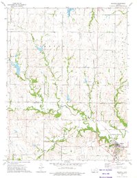
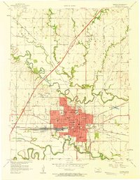 1957 Emporia1958 Print · USGSEmporia's identity as a rail and education center is clear in the late fifties as the turnpike first meets the prairie. Genealogists and historians can trace neighborhood schools like Herbert Sch and Logan Ave Sch, or follow the iron of the Atchison Topeka and Santa Fe through Emporia Junction.3 unique versions available
 - 1957 Map of Plymouth, 1958 Print
 1957 Plymouth1958 Print · USGSLyon and Chase County borders meet here in the late fifties, where the railroad and river define the local geography. Genealogists can trace family roots through sites like Hillside Cemetery and rural centers like Plymouth or the Cottonwood School.2 unique versions available
 - 1957 Map of Lebo NW, 1958 Print
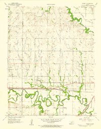
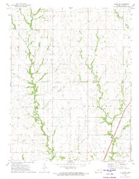
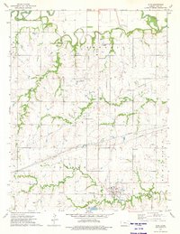
 1957 Lebo NW1958 Print · USGSLyon County, Kansas, at the end of the fifties reveals a landscape shaped by the ATCHISON TOPEKA AND SANTA FE railroad and the Marais des Cygnes River. Genealogists can trace family roots through rural landmarks like Neosho Rapids and Arvonia Cem.3 unique versions available
 - 1959 Map of Hutchinson
 1959 Hutchinson1959 Print · USGSCentral Kansas thrives at the intersection of rail and river in the mid-1950s, as post-war aviation infrastructure reshapes the prairie. Genealogists and historians can trace the paths of the AT&SF RR through Newton and Hutchinson, or locate military sites like Smoky Hill Air Force Base.2 unique versions available
 - 1961 Map of Lawrence
 1961 Lawrence1961 Print · USGSThe Kansas-Missouri borderland shows its mid-century transition from a rail-dependent agricultural region to a suburbanizing landscape. Genealogists can trace family footprints through numerous Cem sites and distinctive terrain landmarks like Graves Mound and Summers Mound.
 - 1967 Map of Gridley NW, 1968 Print
 1967 Gridley NW1968 Print · USGSThe borderlands of Lyon and Coffey counties are captured in the late 1960s during a period of agricultural and industrial utility. Researchers can trace land patterns across Elmendaro and Shell Rock townships or locate the Apostolic Cem and early Oil Wells.
 - 1970 Map of Hartford, 1973 Print
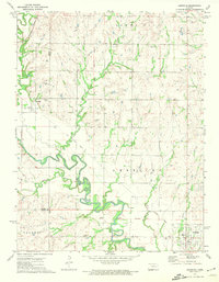
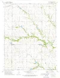
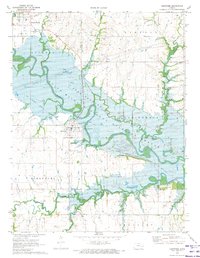 1970 Hartford1973 Print · USGSThe Neosho River valley in the early 1970s shows a landscape reshaped by the waters of the John Redmond Reservoir. Genealogists and local historians can trace family locations near Hartford and find markers like St Marys Cemetery or the Old Railroad Grade.
 - 1971 Map of Miller, 1972 Print
 1971 Miller1972 Print · USGSOsage and Lyon counties are captured here in the early seventies, a landscape where mid-century infrastructure meets older territorial lines. Genealogists can locate family sites near Wilmington, Stotler Ch, and the Old Indian Treaty Boundary.
 - 1971 Map of Reading, 1972 Print
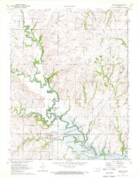 1971 Reading1972 Print · USGSLyon and Osage counties come together here in the early 1970s as the river landscape transitions near the newly formed Melvern Reservoir. Genealogists and local historians can trace family plots at Mt Calvary Cem or follow the rail corridor through Reading and Barclay.
 - 1971 Map of Admire, 1973 Print
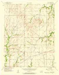
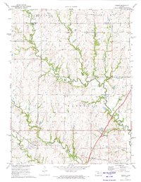 1971 Admire1973 Print · USGSAdmire and the surrounding Flint Hills borderlands are captured here in the early seventies during a period of transition. Researchers can locate the Missouri Pacific rail line and family burial sites at Admire Cem and Pleasant Ridge Cem.
 - 1971 Map of Allen, 1973 Print
 1971 Allen1973 Print · USGSThe rural landscape of Lyon and Wabaunsee counties is captured here in the early 1970s, as the rail era met the modern turnpike. Researchers can trace the Indian Treaty Boundary and locate local landmarks like the Allen Cem and the Missouri Pacific line.2 unique versions available
 - 1971 Map of Bushong, 1973 Print
 1971 Bushong1973 Print · USGSThe eastern Kansas plains of the early 1970s come into focus here, showing the rural communities of Lyon and Wabaunsee counties. Researchers can trace the path of the Old Indian Treaty Grade and locate family history at Agnes City Cem or along the Missouri Pacific railroad line.2 unique versions available
 - 1972 Map of Allen SW, 1974 Print
 1972 Allen SW1974 Print · USGSLyon County in the early 1970s showcases a landscape defined by pioneer-era boundaries and modern transit. Trace local genealogy at the Old Indian Treaty Boundary Township Cem or follow the Old Indian Treaty Boundary through Americus.
 - 1972 Map of Americus, 1974 Print
 1972 Americus1974 Print · USGSLyon and Morris counties in the early 1970s reveal a landscape of river-bottom farms and small-town rail connections. You can trace the Old Indian Treaty Boundary and locate family history at Dunlap Cem or the township of Toledo.
 - 1972 Map of Allen SE, 1974 Print
 1972 Allen SE1974 Print · USGSLyon County in the early seventies shows a landscape where prairie heritage meets modern infrastructure. Genealogists and local historians can trace the Old Treaty Boundary, locate Philips Cem, or follow the A T & S F rail line.
 - 1973 Map of Olpe, 1975 Print
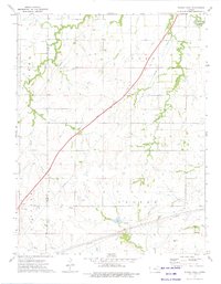
 1973 Olpe1975 Print · USGSLyon County's agricultural heartland is documented here in the early seventies, centered on the community of Olpe. Local researchers can locate rural landmarks such as Harmony Hill Sch, St Joseph Cem, and the path of the Atchison Topeka and Santa Fe railroad.
 - 1973 Map of Shaw Creek, 1975 Print
 1973 Shaw Creek1975 Print · USGSThe Kansas Flint Hills of the early 1970s are captured here where the borders of Lyon, Chase, and Greenwood counties meet. Genealogists and researchers can locate the settlement of Kenbro and trace early petroleum activity through numerous Oil Wells and the winding Verdigris River.
 - 1973 Map of Phenis Creek, 1975 Print
 1973 Phenis Creek1975 Print · USGSLyon and Chase Counties in the early 1970s reveal a landscape of prairie creeks and mid-century energy development. Researchers can locate the Ebenezer Ch, trace the Kansas Toll Road Turnpike, and identify sites within the local Oil Field.
 - 1973 Map of Madison NE, 1975 Print
 1973 Madison NE1975 Print · USGSLyon and Greenwood counties meet in this 1970s landscape defined by the winding Verdigris River and its upland oil fields. Genealogists and historians can trace an Old Railroad Grade and four distinct burial sites, including Fairview Cem and Lena Valley Cem.
 - 1973 Map of Madison, 1975 Print
 1973 Madison1975 Print · USGSMadison and the surrounding Greenwood County countryside appear here in the early 1970s, at a time when the local economy was driven by the Oil Field and the Atchison Topeka and Santa Fe railroad. Genealogists can trace several local burial sites, including Zion Cem and Blakely Cem, alongside the winding Verdigris River.
Showing maps 1-25 of 32
Top cities of Lyon County
- Emporia historical maps
- Americus historical maps
- Olpe historical maps
- Hartford historical maps
- Neosho Rapids historical maps
- Reading historical maps
See more
Frequently asked questions
- What are the different types of historical maps available for Lyon County?
- What is the oldest map of Lyon County?
- Where can I purchase historical maps of Lyon County for my home or office?
- Where can I download high-res historical maps of Lyon County?
- Are there historical topographic maps available for Lyon County?
- Is there historical aerial imagery available for Lyon County?
- Where are historical maps of Lyon County sourced from?