1950s Maps of Lyon County, Kansas
Explore 8 historic maps of Lyon County from the 1950s. These maps offer a rare glimpse into what life looked like during the 1950s — showing old roads, neighborhoods, homes, and landmarks that have changed or disappeared over time.
Whether you're researching your family's past, planning a metal detecting trip, or studying how Lyon County's landscape evolved across the 1950s, these high-resolution maps are a powerful tool for exploring the history of this region.
- Focus on a specific era: All maps on this page are from the 1950s, giving you a focused view of this time period.
- See what’s changed: Compare century-old streets, trails, and buildings to today's modern landscape using overlays and satellite layers.
- Research with precision: Use these maps for genealogy, historical research, land use analysis, or educational projects.
- View, download, or print: Maps are fully viewable online in high resolution, and can be downloaded or printed for your own records.
Start exploring Lyon County's history through authentic maps from the 1950s. This is your window into the past.
Lyon County, KS maps
(8)- 1950 Map of Lawrence
 1950 Lawrence1950 Print · USGSMid-century Kansas and Missouri come alive in this map of the river-valley corridors just as the interstate era was beginning. Researchers can trace the legacy of major rail lines like the Union Pacific RR and locate ancestral roots in towns from Lawrence to Harrisonville.
 - 1955 Map of Hutchinson, 1967 Print
 1955 Hutchinson1967 Print · USGSCentral Kansas in the mid-sixties reveals a landscape of growing reservoirs and evolving transportation corridors. Trace the development of towns like Hutchinson and Abilene alongside the Union Pacific Railroad and the expanding Interstate 70.3 unique versions available
 - 1956 Map of Lawrence, 1967 Print
 1956 Lawrence1967 Print · USGSEastern Kansas and the Missouri border country are captured here during the mid-century transition to the interstate era. Genealogists and local historians can trace family-named terrain like Summers Mound and the footprint of Sunflower Ordnance Works near Baldwin City.4 unique versions available
 - 1957 Map of Lang, 1958 Print
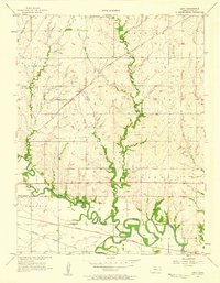 1957 Lang1958 Print · USGSLyon County in the late 1950s is defined by the winding Neosho and Cottonwood Rivers and the vital transit lines of the Santa Fe railroad. Researchers can trace rural landmarks like Lang, find family roots at Hunter Cem, or locate the Old Indian Boundary.2 unique versions available
 - 1957 Map of Emporia, 1958 Print
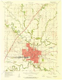 1957 Emporia1958 Print · USGSEmporia's identity as a rail and education center is clear in the late fifties as the turnpike first meets the prairie. Genealogists and historians can trace neighborhood schools like Herbert Sch and Logan Ave Sch, or follow the iron of the Atchison Topeka and Santa Fe through Emporia Junction.3 unique versions available
 - 1957 Map of Plymouth, 1958 Print
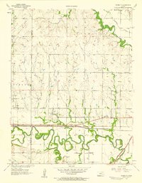 1957 Plymouth1958 Print · USGSLyon and Chase County borders meet here in the late fifties, where the railroad and river define the local geography. Genealogists can trace family roots through sites like Hillside Cemetery and rural centers like Plymouth or the Cottonwood School.2 unique versions available
 - 1957 Map of Lebo NW, 1958 Print
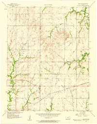 1957 Lebo NW1958 Print · USGSLyon County, Kansas, at the end of the fifties reveals a landscape shaped by the ATCHISON TOPEKA AND SANTA FE railroad and the Marais des Cygnes River. Genealogists can trace family roots through rural landmarks like Neosho Rapids and Arvonia Cem.3 unique versions available
 - 1959 Map of Hutchinson
 1959 Hutchinson1959 Print · USGSCentral Kansas thrives at the intersection of rail and river in the mid-1950s, as post-war aviation infrastructure reshapes the prairie. Genealogists and historians can trace the paths of the AT&SF RR through Newton and Hutchinson, or locate military sites like Smoky Hill Air Force Base.2 unique versions available
End of results
Showing maps 1-8 of 8
Top cities of Lyon County
- Emporia historical maps
- Americus historical maps
- Olpe historical maps
- Hartford historical maps
- Neosho Rapids historical maps
- Reading historical maps
See more
Frequently asked questions
- What are the different types of historical maps available for Lyon County?
- What is the oldest map of Lyon County?
- Where can I purchase historical maps of Lyon County for my home or office?
- Where can I download high-res historical maps of Lyon County?
- Are there historical topographic maps available for Lyon County?
- Is there historical aerial imagery available for Lyon County?
- Where are historical maps of Lyon County sourced from?