1960s Maps of Ness County, Kansas
Explore 12 historic maps of Ness County from the 1960s. These maps offer a rare glimpse into what life looked like during the 1960s — showing old roads, neighborhoods, homes, and landmarks that have changed or disappeared over time.
Whether you're researching your family's past, planning a metal detecting trip, or studying how Ness County's landscape evolved across the 1960s, these high-resolution maps are a powerful tool for exploring the history of this region.
- Focus on a specific era: All maps on this page are from the 1960s, giving you a focused view of this time period.
- See what’s changed: Compare century-old streets, trails, and buildings to today's modern landscape using overlays and satellite layers.
- Research with precision: Use these maps for genealogy, historical research, land use analysis, or educational projects.
- View, download, or print: Maps are fully viewable online in high resolution, and can be downloaded or printed for your own records.
Start exploring Ness County's history through authentic maps from the 1960s. This is your window into the past.
Ness County, KS maps
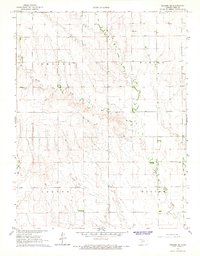
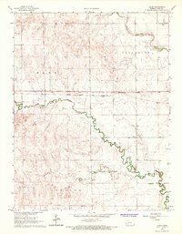
(12)- 1965 Map of Beeler, 1967 Print
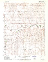 1965 Beeler1967 Print · USGSNess County and the western Kansas plains are captured in the mid-1960s as the rail and road network supported local industry and small-town life. Trace the path of the Atchison Topeka and Santa Fe through Beeler, find the Beeler Cem, and locate early resource sites like the Silica Pit.
 - 1965 Map of Utica SW, 1967 Print
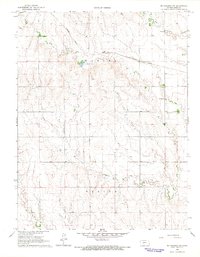
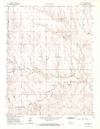 1965 Utica SW1967 Print · USGSNess County was a landscape of expanding petroleum interests and prairie drainage during the mid-sixties. Researchers can trace the development of the Arnold Oil Field and Dumler Oil Field alongside the winding course of Walnut Creek.
 - 1965 Map of Mc Cracken, 1967 Print
 1965 Mc Cracken1967 Print · USGSRush and Ness counties come into focus during the mid-sixties, centered on the railroad town of McCracken. Researchers can trace the Missouri Pacific line past local landmarks like McCracken Cem, Big Timber Creek, and early oil wells.
 - 1966 Map of Alexander, 1967 Print
 1966 Alexander1967 Print · USGSThe rural landscapes of Rush and Ness counties are captured here in the mid-1960s, centered on the rail-side town of Alexander. Genealogists and historians can trace the Atchison Topeka and Santa Fe line, old quarries, and the Weber Oil Field.
 - 1966 Map of Ransom SE, 1967 Print
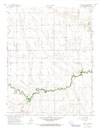
 1966 Ransom SE1967 Print · USGSNess County, Kansas, in the mid-1960s reveals a quiet agricultural landscape defined by township boundaries and prairie drainages. Researchers can locate the Brownell Cem and trace the paths of Bazine Dry Creek and Long Creek.
 - 1966 Map of Mc Cracken SW, 1967 Print
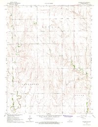
 1966 Mc Cracken SW1967 Print · USGSThe Ness County high plains are captured here in the mid-sixties, showing the intersection of the Missouri Pacific line and rural township life. Genealogists can locate family landmarks such as Ramsey Cem and St Marys Cem along these section lines.
 - 1966 Map of Ness City, 1967 Print
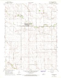
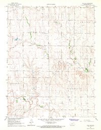
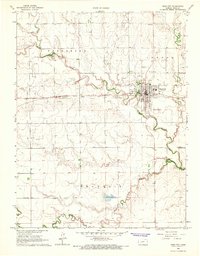 1966 Ness City1967 Print · USGSNess City at the mid-century serves as a hub for the central Kansas plains, where the railroad and river systems meet. Researchers can trace the Atchison Topeka and Santa Fe line, explore multiple Oil Wells, and locate rural burial grounds like Sacred Heart Cem and Chenoworth Cem.
 - 1966 Map of Ness City NE, 1967 Print
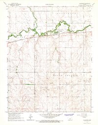
 1966 Ness City NE1967 Print · USGSNess County was defined by its rail-and-creek geography during the mid-sixties, reflecting a classic Kansas prairie landscape. Genealogists and local historians can trace family roots near Fairview Cem or follow the path of the Atchison Topeka and Santa Fe railroad.
 - 1966 Map of Bazine, 1967 Print
 1966 Bazine1967 Print · USGSBazine and the surrounding Ness County plains are captured in the mid-sixties during a period of steady industrial expansion. Researchers can locate family sites near Bazine Cem or trace the path of the Atchison Topeka and Santa Fe railroad.
 - 1966 Map of Laird, 1967 Print
 1966 Laird1967 Print · USGSMid-century Ness County comes to life in this survey showing the intersection of rail and river commerce. Genealogists and historians can trace the Atchison Topeka and Santa Fe line through Laird and locate the Sunshine Oil Field.
 - 1966 Map of Ransom SW, 1967 Print
 1966 Ransom SW1967 Print · USGSNess County was primarily a landscape of winding creek beds and remote townships in the mid-sixties. Researchers can locate the North Star Cem and trace the paths of Wild Horse Creek and Forrester Creek through this rural terrain.
 - 1966 Map of Utica SE, 1967 Print
 1966 Utica SE1967 Print · USGSNess County during the mid-sixties shows a landscape defined by traditional townships and emerging energy production. Researchers can trace land ties and local landmarks like Prairie Chapel Cem, the Dickman Oil Field, and North Fork Walnut Creek.
End of results
Showing maps 1-12 of 12
Top cities of Ness County
- Ness City historical maps
- Ransom historical maps
- Bazine historical maps
- Utica historical maps
- Brownell historical maps
Frequently asked questions
- What are the different types of historical maps available for Ness County?
- What is the oldest map of Ness County?
- Where can I purchase historical maps of Ness County for my home or office?
- Where can I download high-res historical maps of Ness County?
- Are there historical topographic maps available for Ness County?
- Is there historical aerial imagery available for Ness County?
- Where are historical maps of Ness County sourced from?