1980s Maps of Shawnee County, Kansas
Explore 6 historic maps of Shawnee County from the 1980s. These maps offer a rare glimpse into what life looked like during the 1980s — showing old roads, neighborhoods, homes, and landmarks that have changed or disappeared over time.
Whether you're researching your family's past, planning a metal detecting trip, or studying how Shawnee County's landscape evolved across the 1980s, these high-resolution maps are a powerful tool for exploring the history of this region.
- Focus on a specific era: All maps on this page are from the 1980s, giving you a focused view of this time period.
- See what’s changed: Compare century-old streets, trails, and buildings to today's modern landscape using overlays and satellite layers.
- Research with precision: Use these maps for genealogy, historical research, land use analysis, or educational projects.
- View, download, or print: Maps are fully viewable online in high resolution, and can be downloaded or printed for your own records.
Start exploring Shawnee County's history through authentic maps from the 1980s. This is your window into the past.
Shawnee County, KS maps
(6)- 1983 Map of Silver Lake, 1984 Print
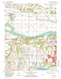 1983 Silver Lake1984 Print · USGSSilver Lake and the western edges of Topeka are captured here in the early eighties as suburban growth meets the Kansas River valley. Researchers can trace the grounds of the Menninger Foundation, locate the Wanamaker Sch, and follow the Union Pacific line through Menoken.
 - 1983 Map of Wakarusa, 1984 Print
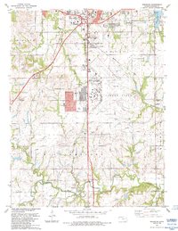 1983 Wakarusa1984 Print · USGSIn the early 1980s, the southern outskirts of the Kansas capital were defined by military aviation and major transportation corridors. Researchers can trace the layout of FORBES FIELD, follow the Kansas Toll Road Turnpike, and locate rural landmarks like Berryton and Yocum Cem.
 - 1983 Map of Topeka, 1984 Print
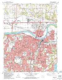 1983 Topeka1984 Print · USGSTopeka during the early eighties shows a dense capital city thriving along the Kansas River and its major rail corridors. Researchers can locate specific institutions like Washburn University, the Capitol, and historic sites such as Mount Hope Cemetery.
 - 1983 Map of Grantville, 1984 Print
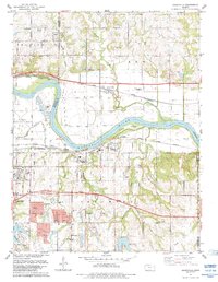 1983 Grantville1984 Print · USGSThe Kansas River valley east of Topeka shows a landscape of busy rail lines and river islands in the early 1980s. Researchers can locate specific family history sites like Grantville Cem, North Fairview Sch, and the riverside settlement of Tecumseh.
 - 1983 Map of Lawrence, 1984 Print
 1983 Lawrence1984 Print · USGSEastern Kansas in the early eighties shows a landscape of growing reservoirs and historic rail towns. Genealogists and historians can trace routes through Topeka and Ottawa, or locate smaller sites like Highland Cem and the settlement of Vassar.
 - 1985 Map of Manhattan, 1986 Print
 1985 Manhattan1986 Print · USGSThe Flint Hills and Kansas River valley are captured in the mid-eighties, showing the growth of Manhattan alongside major military and ecological preserves. Trace local history through the Union Pacific rail lines, the Treaty Boundary, and the infrastructure of Fort Riley.
End of results
Showing maps 1-6 of 6
Top cities of Shawnee County
- Topeka historical maps
- Dover historical maps
- Menoken historical maps
- Silver Lake historical maps
- Auburn historical maps
- Tecumseh historical maps
See more
Frequently asked questions
- What are the different types of historical maps available for Shawnee County?
- What is the oldest map of Shawnee County?
- Where can I purchase historical maps of Shawnee County for my home or office?
- Where can I download high-res historical maps of Shawnee County?
- Are there historical topographic maps available for Shawnee County?
- Is there historical aerial imagery available for Shawnee County?
- Where are historical maps of Shawnee County sourced from?