1970s Maps of Wabaunsee County, Kansas
Explore 15 historic maps of Wabaunsee County from the 1970s. These maps offer a rare glimpse into what life looked like during the 1970s — showing old roads, neighborhoods, homes, and landmarks that have changed or disappeared over time.
Whether you're researching your family's past, planning a metal detecting trip, or studying how Wabaunsee County's landscape evolved across the 1970s, these high-resolution maps are a powerful tool for exploring the history of this region.
- Focus on a specific era: All maps on this page are from the 1970s, giving you a focused view of this time period.
- See what’s changed: Compare century-old streets, trails, and buildings to today's modern landscape using overlays and satellite layers.
- Research with precision: Use these maps for genealogy, historical research, land use analysis, or educational projects.
- View, download, or print: Maps are fully viewable online in high resolution, and can be downloaded or printed for your own records.
Start exploring Wabaunsee County's history through authentic maps from the 1970s. This is your window into the past.
Wabaunsee County, KS maps
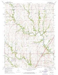
(15)- 1971 Map of Miller, 1972 Print
 1971 Miller1972 Print · USGSOsage and Lyon counties are captured here in the early seventies, a landscape where mid-century infrastructure meets older territorial lines. Genealogists can locate family sites near Wilmington, Stotler Ch, and the Old Indian Treaty Boundary.
 - 1971 Map of Admire, 1973 Print
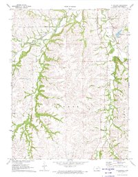
 1971 Admire1973 Print · USGSAdmire and the surrounding Flint Hills borderlands are captured here in the early seventies during a period of transition. Researchers can locate the Missouri Pacific rail line and family burial sites at Admire Cem and Pleasant Ridge Cem.
 - 1971 Map of Allendorph, 1973 Print
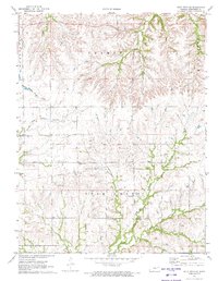
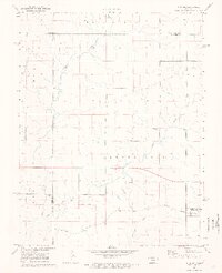
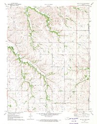
 1971 Allendorph1973 Print · USGSWabaunsee County in the early seventies is a landscape of creek-fed valleys and rural townships. Genealogists and historians can trace the Indian Treaty Boundary and locate family burial sites at Fairview Cem or explore the rail corridor of the Chicago Rock Island and Pacific.2 unique versions available
 - 1971 Map of Alta Vista SE, 1973 Print
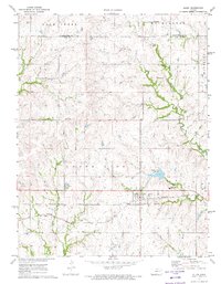
 1971 Alta Vista SE1973 Print · USGSWabaunsee County is shown in the early seventies as a landscape of rural townships and historic borders. Genealogists and historians can trace the Old Indian Treaty Boundary and locate family sites near Prairie View Cem or Immanuel Ch.
 - 1971 Map of Allen, 1973 Print
 1971 Allen1973 Print · USGSThe rural landscape of Lyon and Wabaunsee counties is captured here in the early 1970s, as the rail era met the modern turnpike. Researchers can trace the Indian Treaty Boundary and locate local landmarks like the Allen Cem and the Missouri Pacific line.2 unique versions available
 - 1971 Map of Volland, 1973 Print
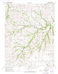
 1971 Volland1973 Print · USGSWabaunsee County in the early seventies is revealed through its rail-side settlements and rural townships. Trace family history at Fix Cem and East Templin Cem, or follow the Chicago Rock Island and Pacific line through Volland.
 - 1971 Map of Bushong, 1973 Print
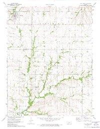
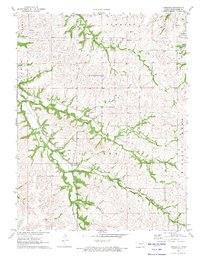
 1971 Bushong1973 Print · USGSThe eastern Kansas plains of the early 1970s come into focus here, showing the rural communities of Lyon and Wabaunsee counties. Researchers can trace the path of the Old Indian Treaty Grade and locate family history at Agnes City Cem or along the Missouri Pacific railroad line.2 unique versions available
 - 1971 Map of Keene, 1974 Print
 1971 Keene1974 Print · USGSWabaunsee County in the early 1970s is a landscape of winding creek valleys and quiet rural crossroads. Researchers can trace the layout of the Keene community, locating local landmarks like the Wesleyan Ch, Keene Cem, and the Fish Hatchery.2 unique versions available
 - 1971 Map of Alta Vista, 1974 Print
 1971 Alta Vista1974 Print · USGSThe Flint Hills region of Wabaunsee and Morris counties is shown here in the early seventies, centered on the rail town of Alta Vista. Researchers can trace the Old Indian Treaty Boundary across the landscape or locate local landmarks like the Garfield Cemetery and the Beman Cemetery.
 - 1971 Map of Lake Wabaunsee, 1974 Print
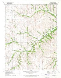
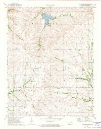 1971 Lake Wabaunsee1974 Print · USGSWabaunsee County in the early 1970s shows a landscape of deep creek valleys and the early development of Lake Wabaunsee. Genealogists and historians can trace the Old Indian Treaty Boundary or locate the settlement of Graves.
 - 1971 Map of Eskridge, 1974 Print
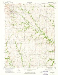 1971 Eskridge1974 Print · USGSWabaunsee County enters the 1970s as a landscape of rail-line settlements and active prairie energy extraction. Researchers can trace the layout of Eskridge, follow the Atchison Topeka and Santa Fe tracks, and locate the Eskridge Cem.2 unique versions available
 - 1971 Map of Dwight, 1974 Print
 1971 Dwight1974 Print · USGSThe town of Dwight and its surrounding prairie landscape are shown here in the early 1970s at the intersection of Morris and Geary counties. Local historians can trace the Chicago Rock Island and Pacific rail line and search for family roots at Swartz Cem or Kelso Cem.
 - 1971 Map of Council Grove, 1974 Print
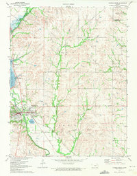 1971 Council Grove1974 Print · USGSMorris County in the early 1970s reveals a landscape shaped by water engineering and deep territorial history. Researchers can trace the Old Indian Treaty Boundary and explore the mid-century recreation sites like the Drive-in Theater and Richey Cove South Recreation Area.2 unique versions available
 - 1971 Map of White City NE, 1974 Print
 1971 White City NE1974 Print · USGSGeary County in the early 1970s is characterized by its network of creek-side farmsteads and rural cemeteries. Genealogists can trace family footprints near Upper Humboldt Cem, Quaker Cem, and the historic Townhall site.
 - 1971 Map of Hessdale, 1974 Print
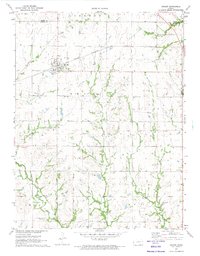
 1971 Hessdale1974 Print · USGSWabaunsee County in the early 1970s reveals a quiet landscape of creek-side settlements and historical land divisions. Researchers can trace the Indian Treaty Boundary and locate family-named sites like the Swedish Cem and Hessdale.2 unique versions available
End of results
Showing maps 1-15 of 15
Top cities of Wabaunsee County
- Newbury historical maps
- Alma historical maps
- Wilmington historical maps
- Eskridge historical maps
- Maple Hill historical maps
- Wabaunsee historical maps
See more
Frequently asked questions
- What are the different types of historical maps available for Wabaunsee County?
- What is the oldest map of Wabaunsee County?
- Where can I purchase historical maps of Wabaunsee County for my home or office?
- Where can I download high-res historical maps of Wabaunsee County?
- Are there historical topographic maps available for Wabaunsee County?
- Is there historical aerial imagery available for Wabaunsee County?
- Where are historical maps of Wabaunsee County sourced from?