Old Maps of Adair County, Kentucky for Hiking & Exploration
Hike through history with 106 historic maps of Adair County. Explore old trails, ghost towns, and forgotten backroads — perfect for outdoor adventurers and local explorers.
- Rediscover forgotten places: Map out old mining camps, roads, and footpaths that no longer exist on modern maps.
- Layer with modern tools: Combine with LiDAR or satellite views to plan hikes through historical terrain.
- Made for exploration: Popular among hikers, overlanders, and local history lovers.
Use these maps to find adventure and explore the hidden past of Adair County.
Adair County, KY maps
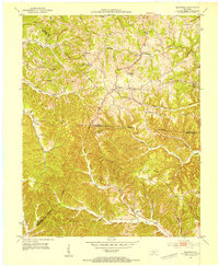
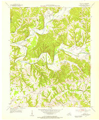
(106)- 1952 Map of Clementsville, 1953 Print
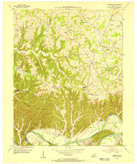
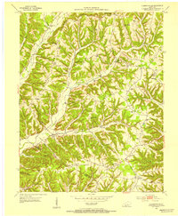 1952 Clementsville1953 Print · USGSCasey County in the early fifties is mapped here as a labyrinth of high ridges and creek-bottom settlements. Genealogists and historians can trace family roots through numerous highland schools and churches, including Casey Creek Sch, White Oak Ch, and the Noel Chapel Cem.4 unique versions available
 - 1952 Map of Mannsville, 1954 Print
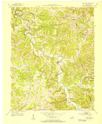
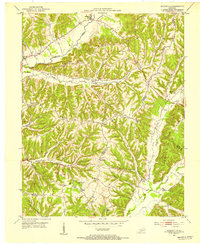 1952 Mannsville1954 Print · USGSThe Taylor and Casey County borderlands are documented here at mid-century, showing a landscape of high ridges and rural settlements. Genealogists can locate family-named landmarks and institutions like Gaddis Ridge Cem, Farmers Sch, and Mt Zion Ch.2 unique versions available
 - 1953 Map of Gradyville, 1954 Print
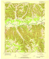
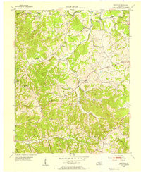 1953 Gradyville1954 Print · USGSAdair County life in the early fifties is centered on the creek valleys and crossroads of the Gradyville area. Researchers can trace family history through numerous small burial grounds and rural schools like Jones Chapel Sch and Wheeler Cem.2 unique versions available
 - 1953 Map of Campbellsville, 1954 Print
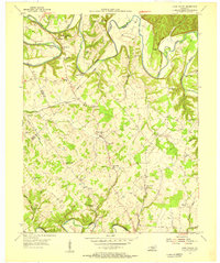
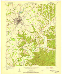 1953 Campbellsville1954 Print · USGSTaylor County at the dawn of the 1950s shows the growth of Campbellsville alongside its deep rural roots. Researchers can trace numerous local landmarks including the Wee Yan Sch, Old Pitman Ch, and the winding Robinson Creek.2 unique versions available
 - 1953 Map of Breeding, 1954 Print
 1953 Breeding1954 Print · USGSThe hill country of south-central Kentucky is captured here in the early fifties, showing the rural communities along the Adair and Cumberland county lines. Researchers can trace the locations of old schoolhouses and country churches like Rowetown Sch, Chestnut Grove Ch, and Saltpeter Cave.3 unique versions available
 - 1953 Map of Amandaville, 1954 Print
 1953 Amandaville1954 Print · USGSAdair and Cumberland counties appear here in the early fifties, showing a rural landscape of ridges and creek-bottom settlements. Genealogists can trace family footprints across McGinnis Cem, Inroad, and schools like Walnut Grove Sch or Elliott Sch.4 unique versions available
 - 1953 Map of Montpelier, 1955 Print
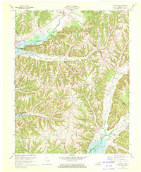
 1953 Montpelier1955 Print · USGSAdair and Russell Counties in the early fifties show a landscape of small agricultural hubs connected by winding creek-side roads. Researchers can trace family roots at Gentrys Mill, find numerous rural schools like Rainfall Sch, and locate family burial sites such as Watkins Cem.2 unique versions available
 - 1953 Map of Gresham, 1955 Print
 1953 Gresham1955 Print · USGSGreen County in the early fifties is mapped here as a landscape of winding river bends and tight-knit rural communities. Researchers can trace family sites and local history at Gresham, Miller Chapel, and the Summershade Sch along the banks of Russell Creek.4 unique versions available
 - 1953 Map of Creelsboro, 1955 Print
 1953 Creelsboro1955 Print · USGSSouthern Kentucky's river valleys and high ridges are captured here in the early fifties, centering on the winding Cumberland River. Researchers can locate vanished rural landmarks like Old Olga, the Highway Mission, and the Cherry Grove Sch.3 unique versions available
 - 1953 Map of East Fork, 1955 Print
 1953 East Fork1955 Print · USGSCentral Kentucky's rural landscape is captured here in the early 1950s, centered on the winding East Fork Little Barren River. Genealogists can trace family names through numerous landmarks like Ackee Cem, Mud Slash Sch, and Union Chapel.2 unique versions available
 - 1953 Map of Dunnville, 1955 Print
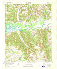
 1953 Dunnville1955 Print · USGSThe Green River valley and the rural ridges of Adair and Casey Counties are frozen in time here during the early fifties. Genealogists can trace family landmarks across the landscape, from Millerfield to country schools like Poplar Grove Sch and Tarter Sch.2 unique versions available
 - 1953 Map of Cane Valley, 1955 Print
 1953 Cane Valley1955 Print · USGSAdair and Taylor Counties are seen here in the early fifties, characterized by traditional river-bend farming and a high density of rural schoolhouses. Genealogists can trace family names at the Confederate Cem, Tampico Sch, or Faulkner Sulphur Spring.2 unique versions available
 - 1954 Map of Knifley, 1955 Print
 1954 Knifley1955 Print · USGSAdair County in the mid-fifties is a landscape of high ridges and winding river valleys before modern development reshaped the rural landscape. Genealogists and historians can locate dozens of country institutions, from the Little Cake Sch to the Bearwallow Ch and Knifley post office.2 unique versions available
 - 1954 Map of Columbia, 1955 Print
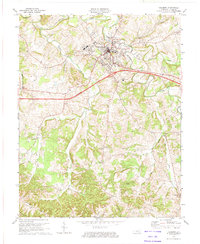
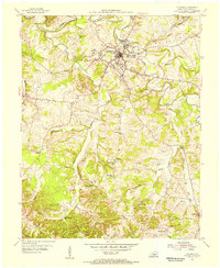 1954 Columbia1955 Print · USGSAdair County during the mid-fifties shows a rural landscape centered on the growth of Columbia. Researchers can trace dozens of family landmarks and local institutions, from Lindsey Wilson College to the Yellow Hammer Sch and Smith Chapel.
 - 1954 Map of Russell Springs, 1955 Print
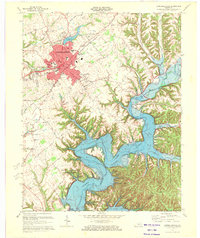
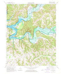
 1954 Russell Springs1955 Print · USGSThe Russell Springs area in the mid-fifties shows a rural landscape adapting to the new shoreline of Lake Cumberland. Local researchers can trace family roots through numerous landmarks like Webbs Cross Roads, Central High Sch, and Beckham Ridge Ch.2 unique versions available
 - 1956 Map of Corbin, 1966 Print
 1956 Corbin1966 Print · USGSThe Kentucky and Tennessee borderlands are captured here in the mid-fifties, showing the region's shift toward modern interstate travel and reservoir development. Genealogists and historians can trace old community lines near Albany and Monticello or locate early rail junctions along the Southern and Tennessee Central lines.3 unique versions available
 - 1957 Map of Winchester, 1968 Print
 1957 Winchester1968 Print · USGSCentral Kentucky's landscape in the mid-twentieth century features the sprawling Fort Knox and the early parkway system. Genealogists and historians can trace rail lines like the Southern Railway and find landmarks from Bernheim Forest to Pilot Knob.3 unique versions available
 - 1958 Map of Corbin
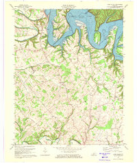
 1958 Corbin1958 Print · USGSThe Upper Cumberland borderlands appear in the late 1950s as massive reservoirs and early atomic-era growth reshape the region. Trace family roots and vanished landmarks near Lake Cumberland, Oak Ridge, and the Cumberland National Forest.
 - 1960 Map of Winchester
 1960 Winchester1960 Print · USGSCentral Kentucky's diverse landscape is shown here at mid-century, from the bluegrass plains to the rugged Pottsville Escarpment. Genealogists and historians can trace the rail-and-river network connecting towns like Bardstown and Stanford alongside landmarks like Lake Cumberland.
 - 1970 Map of Campbellsville, 1972 Print
 1970 Campbellsville1972 Print · USGSCampbellsville and the newly formed Green River Lake are captured in the early seventies during a period of significant regional growth. Local researchers can trace the development of Campbellsville College and locate rural landmarks like Shady Grove Ch and Durham Sch.3 unique versions available
 - 1970 Map of Cane Valley, 1972 Print
 1970 Cane Valley1972 Print · USGSAdair and Green counties are captured here in the early seventies, a period defined by the sprawling waters of Green River Lake. Researchers can locate historic family burial sites like Green River Hill Confederate Cem and rural crossroads like Cane Valley and Coburg.4 unique versions available
 - 1970 Map of Dunnville, 1972 Print
 1970 Dunnville1972 Print · USGSAdair and Casey counties appear during the early 1970s as the Green River Lake reservoir reshapes the valley. Researchers can find numerous family burial grounds and country churches like Williams Cem, Shady Grove Ch, and the Mt Calvary Cem Ch.
 - 1970 Map of Knifley, 1972 Print
 1970 Knifley1972 Print · USGSAdair County communities meet the rising waters of the Green River in the early seventies. Genealogists can locate family-named sites such as Damron Cem, Little Cake Ch, and the old Robinson Ridge School Rd.2 unique versions available
 - 1970 Map of Mannsville, 1972 Print
 1970 Mannsville1972 Print · USGSTaylor County settlement meets the rising waters of the Green River reservoir in the 1970s. Genealogists can trace family connections at Christie Chapel, Eastridge Cem, and the small community of Feathersburg tucked between the ridges.
 - 1973 Map of Columbia, 1974 Print
 1973 Columbia1974 Print · USGSAdair County in the early seventies shows a landscape of ridge-top farms and new infrastructure like the Cumberland Parkway Toll Road. Genealogists and historians can trace the foundations of Lindsey Wilson College or locate remote country landmarks like Santa Fee Ch and the settlement of Glens Fork.2 unique versions available
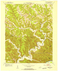
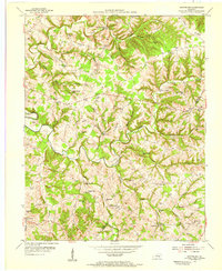
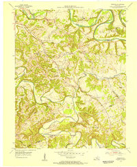
Showing maps 1-25 of 106
Top cities of Adair County
Frequently asked questions
- What are the different types of historical maps available for Adair County?
- What is the oldest map of Adair County?
- Where can I purchase historical maps of Adair County for my home or office?
- Where can I download high-res historical maps of Adair County?
- Are there historical topographic maps available for Adair County?
- Is there historical aerial imagery available for Adair County?
- Where are historical maps of Adair County sourced from?