1900-1909 Maps of Hopkins County, Kentucky
Explore 7 historic maps of Hopkins County from 1900-1909. These maps offer a rare glimpse into what life looked like during the 1900s — showing old roads, neighborhoods, homes, and landmarks that have changed or disappeared over time.
Whether you're researching your family's past, planning a metal detecting trip, or studying how Hopkins County's landscape evolved across the 1900s, these high-resolution maps are a powerful tool for exploring the history of this region.
- Focus on a specific era: All maps on this page are from the 1900s, giving you a focused view of this time period.
- See what’s changed: Compare century-old streets, trails, and buildings to today's modern landscape using overlays and satellite layers.
- Research with precision: Use these maps for genealogy, historical research, land use analysis, or educational projects.
- View, download, or print: Maps are fully viewable online in high resolution, and can be downloaded or printed for your own records.
Start exploring Hopkins County's history through authentic maps from the 1900s. This is your window into the past.
Hopkins County, KY maps
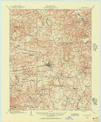
(7)- 1907 Map of Earlington
 1907 Earlington1907 Print · USGSWestern Kentucky coal and farm country comes alive in the early 1900s, centered on the growing hubs of Madisonville and Earlington. Genealogists and historians can trace dozens of rural schools and churches like Ramsey School, Nebo, and Mt Carmel Church.
 - 1908 Map of Calhoun
 1908 Calhoun1908 Print · USGSWestern Kentucky's river-driven economy is on full display in the first decade of the twentieth century, centered on the winding Green River. Researchers can trace ancestral locations in Beechgrove, Ashbyburg, and Calhoun, or locate vanished river crossings like Steamboat Ferry.2 unique versions available
 - 1908 Map of Princeton, 1957 Print
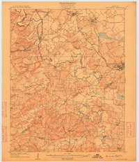
 1908 Princeton1957 Print · USGSWestern Kentucky at the dawn of the twentieth century shows a landscape tied together by rail lines and rural schools. Genealogists can trace family footprints across dozens of local landmarks like Heathen Hill School, Otter Pond, and Briarfield Church.
 - 1909 Map of Dawson Springs
 1909 Dawson Springs1909 Print · USGSWestern Kentucky at the peak of its rail-and-river era shows a landscape dotted with country schools and small depots. Genealogists can trace family roots through numerous landmarks like Hamby Sta, Pooles Mill Bridge, and Cross Roads Church.
 - 1909 Map of Earlington
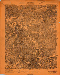
 1909 Earlington1909 Print · USGSWestern Kentucky’s coal and rail corridor comes into focus in the years before the Great War. Researchers can trace ancestral locations through a dense network of local landmarks like Silent Run PO, Johnson Island Church, and Oakland Store.3 unique versions available
 - 1909 Map of Madisonville
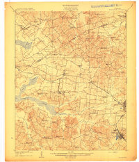
 1909 Madisonville1909 Print · USGSWestern Kentucky at the peak of the coal and rail era shows a landscape defined by river crossings and growing mining towns. Researchers can locate dozens of early rural landmarks, from Island Ford and Barnsley to the New Providence School and Brier Creek Church.3 unique versions available
 - 1909 Map of Providence
 1909 Providence1909 Print · USGSWestern Kentucky's coal and river country comes alive in the early 1900s as railroads begin to reshape the Tradewater Valley. Genealogists and researchers can trace old river crossings like Rices Mill Jericho Ford or locate lost community landmarks such as Numms Sta Gladstone PO and Rock Spring Church.3 unique versions available
End of results
Showing maps 1-7 of 7
Top cities of Hopkins County
- Madisonville historical maps
- Dawson Springs historical maps
- Earlington historical maps
- Nortonville historical maps
- Mortons Gap historical maps
- White Plains historical maps
See more
Frequently asked questions
- What are the different types of historical maps available for Hopkins County?
- What is the oldest map of Hopkins County?
- Where can I purchase historical maps of Hopkins County for my home or office?
- Where can I download high-res historical maps of Hopkins County?
- Are there historical topographic maps available for Hopkins County?
- Is there historical aerial imagery available for Hopkins County?
- Where are historical maps of Hopkins County sourced from?