1950s Maps of Hopkins County, Kentucky
Explore 22 historic maps of Hopkins County from the 1950s. These maps offer a rare glimpse into what life looked like during the 1950s — showing old roads, neighborhoods, homes, and landmarks that have changed or disappeared over time.
Whether you're researching your family's past, planning a metal detecting trip, or studying how Hopkins County's landscape evolved across the 1950s, these high-resolution maps are a powerful tool for exploring the history of this region.
- Focus on a specific era: All maps on this page are from the 1950s, giving you a focused view of this time period.
- See what’s changed: Compare century-old streets, trails, and buildings to today's modern landscape using overlays and satellite layers.
- Research with precision: Use these maps for genealogy, historical research, land use analysis, or educational projects.
- View, download, or print: Maps are fully viewable online in high resolution, and can be downloaded or printed for your own records.
Start exploring Hopkins County's history through authentic maps from the 1950s. This is your window into the past.
Hopkins County, KY maps
(22)- 1952 Map of Sacramento, 1953 Print
 1952 Sacramento1953 Print · USGSMcLean County and the surrounding river bottoms are captured here in the early fifties, centered on the community of Sacramento. Local historians can trace early petroleum sites like an Oil Well and rural landmarks such as West Chapel and Brazzel Bridge.2 unique versions available
 - 1952 Map of Calhoun, 1954 Print
 1952 Calhoun1954 Print · USGSMcLean County thrived along the banks of the winding Green River in the early fifties, where river commerce and rural agriculture met. Genealogists can trace family landmarks and community hubs like Shutts Chapel, Jewel City, and the St Sebastian Sch.3 unique versions available
 - 1952 Map of Crofton, 1954 Print
 1952 Crofton1954 Print · USGSCrofton and the northern Christian County borderlands are captured here in the early fifties, where the railroad and coal industry shaped the landscape. Genealogists can locate numerous family burial sites and rural landmarks like Old Petersburg Ch, Orange Grove Sch, and Monk-Radliff Cem.
 - 1952 Map of Beech Grove, 1954 Print
 1952 Beech Grove1954 Print · USGSThe Green River valley in the early fifties shows a rural Kentucky landscape shaped by both water and rail. Researchers can locate river-access points like Steamboat Landing, the Louisville and Nashville railroad, and local landmarks such as Onton Cem.2 unique versions available
 - 1952 Map of Hanson, 1954 Print
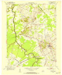
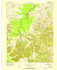
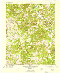
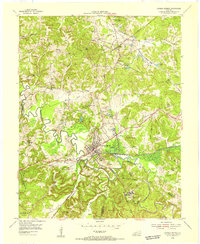
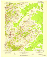 1952 Hanson1954 Print · USGSHopkins County in the early 1950s shows a landscape of rural family homesteads and early oil extraction along the Louisville and Nashville railroad. Genealogists can trace local roots through numerous sites like the County Farm, Slaughtersville, and Old Salem Cem.
 - 1953 Map of Dawson Springs SE
 1953 Dawson Springs SE1953 Print · USGSNorthwestern Christian County comes to life in this early 1950s survey, showing a landscape of small settlements and emerging coal mines. Genealogists and local historians can trace family roots through landmarks like Bethel Ch, Consolation Sch, and the Ladd Cem.2 unique versions available
 - 1953 Map of Nortonville, 1954 Print
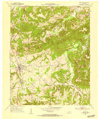
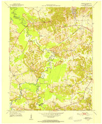
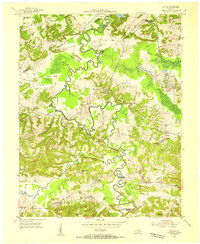
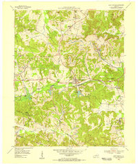
 1953 Nortonville1954 Print · USGSThe rail and mining landscape of Hopkins County is on full display in the early 1950s, showing a region defined by its industrial resources. Genealogists can trace family heritage through sites like Old Salem Ch and Whitfield Cem or the rural settlement of White Plains.
 - 1953 Map of Madisonville East, 1954 Print
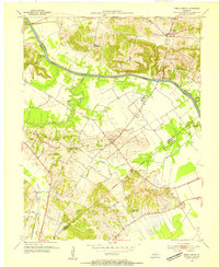
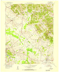
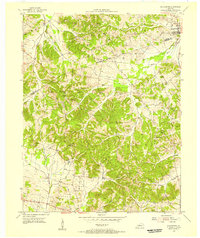
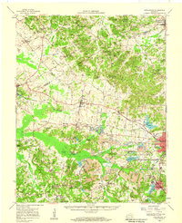
 1953 Madisonville East1954 Print · USGSThe coal-rich corridor of Hopkins County is revealed in the early fifties, showing the heavy intersection of industry and community. Genealogists and researchers can trace family landmarks like St Marys Ch, Barnsley, and the extensive Strip Mines that shaped this landscape.
 - 1953 Map of Millport, 1954 Print
 1953 Millport1954 Print · USGSWestern Kentucky coal country in the early fifties shows a landscape balancing river bottom agriculture with industrial expansion. Trace family roots at Antioch Ch, locate Millport on the rail line, or map the early footprints of the Strip Mine fields.
 - 1953 Map of Graham, 1954 Print
 1953 Graham1954 Print · USGSWestern Kentucky coal country and river bottomlands come alive in the early fifties, documenting the landscape of the Pond River forks. Genealogists and historians can trace community roots through numerous landmarks like Yeargins Chapel, Mt Carmel, and the Illinois Central rail line.
 - 1954 Map of Evansville
 1954 Evansville1954 Print · USGSThe Ohio River borderlands between Indiana and Kentucky appear here during a period of robust industrial and military growth. Genealogists and researchers can trace the rail corridors of the Illinois Central and find landmarks like US Lock and Dam No 48 or Camp Breckinridge.
 - 1954 Map of Nebo, 1955 Print
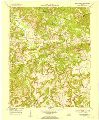
 1954 Nebo1955 Print · USGSWestern Kentucky in the mid-fifties shows a landscape of drainage ditches and family farms spanning the Hopkins and Webster county line. Researchers can trace rural life through numerous landmarks like Hayes Chapel, the Stanhope Cem, and an Old Railroad Grade.
 - 1954 Map of Providence, 1955 Print
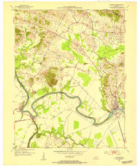
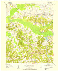
 1954 Providence1955 Print · USGSThe Western Kentucky coalfields and rail hubs of Webster and Hopkins counties come alive in the mid-fifties. Researchers can trace family roots at New Harmony Cem and Wynn Cem or locate industrial sites like Mine No 10 and the ILLINOIS CENTRAL rail lines.
 - 1954 Map of Olney, 1955 Print
 1954 Olney1955 Print · USGSCaldwell and Hopkins counties meet along the Tradewater River in the mid-1950s, a period of quiet rural life and deep-rooted family farms. Genealogists can trace family names across a landscape filled with landmarks like Grower Cem, McGregor Cem, and the settlement of Lewistown.
 - 1954 Map of Dalton, 1955 Print
 1954 Dalton1955 Print · USGSMid-century western Kentucky comes alive along the winding Tradewater River and its many historic crossings. Genealogists and researchers can trace rural life through landmarks like Kirkwood Springs, the Illinois Central rail line, and family sites such as Harper Cem.2 unique versions available
 - 1954 Map of Coiltown, 1955 Print
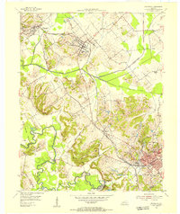
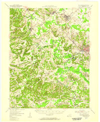
 1954 Coiltown1955 Print · USGSHopkins County was a hub of coal production in the 1950s, where rail lines and surface mines shaped the rural landscape. Researchers can find specific family landmarks and community centers such as Rabbit Ridge, Old Beulah Church, and the Stoney Point Mine.
 - 1954 Map of Slaughters, 1955 Print
 1954 Slaughters1955 Print · USGSSlaughters and the rugged Shake Rag Hills are documented here in the mid-fifties, during a period of transition for the Webster and Hopkins County line. Genealogists can locate numerous family burial sites like Tapp Cem and country churches such as Oakley Home Ch.2 unique versions available
 - 1954 Map of Dawson Springs, 1955 Print
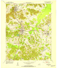
 1954 Dawson Springs1955 Print · USGSDawson Springs was a center of coal mining and public health in the mid-1950s. Researchers can trace the legacy of the Dawson Daylight Mine, locate the Outwood Veterans Hospital, and find numerous family burial sites like McNeely Cem.
 - 1954 Map of Saint Charles, 1956 Print
 1954 Saint Charles1956 Print · USGSWestern Kentucky's coal country comes alive in the mid-1950s as the railroad and mining industries shape the landscape around Saint Charles. Trace ancestral roots through rural sites like Daniel Boone or locate family plots at Christian Privilege Cem & Ch and Hamby Cem.
 - 1954 Map of Providence, 1957 Print
 1954 Providence1957 Print · USGSCoal and rail define this Western Kentucky corridor during the mid-fifties as Providence and Clay thrive along major transit lines. Researchers can trace the industrial footprint of the Stony Point Mines or locate family roots at the Odd Fellows Cem and White Oak Ch.
 - 1954 Map of Earlington, 1958 Print
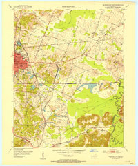
 1954 Earlington1958 Print · USGSHopkins and Webster Counties in the mid-fifties show a landscape shaped by coal extraction and rail transit. Researchers can trace the heritage of vanished homesteads and local landmarks like Sixth Vein Mine, Slaughtersville, and Munns Sch.
 - 1957 Map of Evansville, 1969 Print
 1957 Evansville1969 Print · USGSIndiana and Kentucky meet along the Ohio River in this mid-century survey of a vital industrial and transport corridor. Genealogists and historians can trace the development of river towns like Owensboro and Newburgh or locate old rail lines like the Southern Ry.3 unique versions available
End of results
Showing maps 1-22 of 22
Top cities of Hopkins County
- Madisonville historical maps
- Dawson Springs historical maps
- Earlington historical maps
- Nortonville historical maps
- Mortons Gap historical maps
- White Plains historical maps
See more
Frequently asked questions
- What are the different types of historical maps available for Hopkins County?
- What is the oldest map of Hopkins County?
- Where can I purchase historical maps of Hopkins County for my home or office?
- Where can I download high-res historical maps of Hopkins County?
- Are there historical topographic maps available for Hopkins County?
- Is there historical aerial imagery available for Hopkins County?
- Where are historical maps of Hopkins County sourced from?