1940s Maps of Louisville, Kentucky
Explore 5 historic maps of Louisville from the 1940s. These maps offer a rare glimpse into what life looked like during the 1940s — showing old roads, neighborhoods, homes, and landmarks that have changed or disappeared over time.
Whether you're researching your family's past, planning a metal detecting trip, or studying how Louisville's landscape evolved across the 1940s, these high-resolution maps are a powerful tool for exploring the history of this region.
- Focus on a specific era: All maps on this page are from the 1940s, giving you a focused view of this time period.
- See what’s changed: Compare century-old streets, trails, and buildings to today's modern landscape using overlays and satellite layers.
- Research with precision: Use these maps for genealogy, historical research, land use analysis, or educational projects.
- View, download, or print: Maps are fully viewable online in high resolution, and can be downloaded or printed for your own records.
Start exploring Louisville's history through authentic maps from the 1940s. This is your window into the past.
Louisville, KY maps
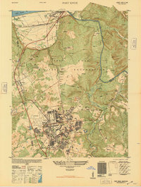
(5)- 1943 Map of Vine Grove
 1943 Vine Grove1943 Print · USGSHardin and Meade Counties appear here during a period of massive mid-century growth at Fort Knox. Genealogists can trace family homesteads near landmarks like Stovall Chapel, Red Hill, and the many rural schools including Hays Sch and Deckard Sch.
 - 1946 Map of Fort Knox
 1946 Fort Knox1946 Print · USGSFort Knox and the surrounding Kentucky riverlands are captured just after the war as the military installation reached its modern maturity. Researchers can trace the layout of Godman Field, locate the famous Bullion Depository, and find family landmarks like Montgomery Cem or the town of West Point.
 - 1946 Map of Jeffersonville
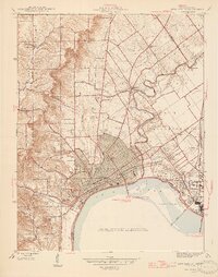
 1946 Jeffersonville1946 Print · USGSSouthern Indiana sits at a crossroads of river and rail during the mid-1940s, as the industrial grid of Jeffersonville meets the rural Clark Military Grant. Researchers can trace family roots at Walnut Ridge Cem or locate vanished schoolhouses like Lane Sch and Middle Road Sch.2 unique versions available
 - 1946 Map of New Albany
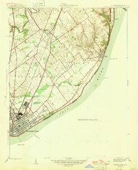
 1946 New Albany1946 Print · USGSThe Indiana shoreline of the Ohio River bustles with mid-century activity as railroads and bridges connect New Albany to the south. Researchers can trace historic local sites like Blackiston Mill, the County Infirmary, and Graceland Cem near the Falls of the Ohio.2 unique versions available
 - 1946 Map of Vine Grove, 1959 Print
 1946 Vine Grove1959 Print · USGSMid-century Hardin County is defined by the massive expansion of the Fort Knox Military Reservation and its surrounding rail-and-highway hubs. Researchers can trace dozens of family cemeteries and vanished landmarks like the Woolridge Ferry Bridge, Sherrard Sch, and the community of Pitts Point.
End of results
Showing maps 1-5 of 5
Top cities near Louisville
- Jeffersonville historical maps
- New Albany historical maps
- Jeffersontown historical maps
- Clarksville historical maps
- Shively historical maps
- Mount Washington historical maps
See more
Top neighborhoods of Louisville
- Beechland Beach historical maps
- Glenview Heights historical maps
- Juniper Beach historical maps
- Gulthrie Beach historical maps
- Harrods Creek historical maps
- Riverside Beach historical maps
See more
Frequently asked questions
- What are the different types of historical maps available for Louisville?
- What is the oldest map of Louisville?
- Where can I purchase historical maps of Louisville for my home or office?
- Where can I download high-res historical maps of Louisville?
- Are there historical topographic maps available for Louisville?
- Is there historical aerial imagery available for Louisville?
- Where are historical maps of Louisville sourced from?