1930s Maps of Louisville, Kentucky
Explore 5 historic maps of Louisville from the 1930s. These maps offer a rare glimpse into what life looked like during the 1930s — showing old roads, neighborhoods, homes, and landmarks that have changed or disappeared over time.
Whether you're researching your family's past, planning a metal detecting trip, or studying how Louisville's landscape evolved across the 1930s, these high-resolution maps are a powerful tool for exploring the history of this region.
- Focus on a specific era: All maps on this page are from the 1930s, giving you a focused view of this time period.
- See what’s changed: Compare century-old streets, trails, and buildings to today's modern landscape using overlays and satellite layers.
- Research with precision: Use these maps for genealogy, historical research, land use analysis, or educational projects.
- View, download, or print: Maps are fully viewable online in high resolution, and can be downloaded or printed for your own records.
Start exploring Louisville's history through authentic maps from the 1930s. This is your window into the past.
Louisville, KY maps
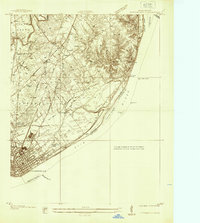
(5)- 1932 Map of La Grange
 1932 La Grange1932 Print · USGSThe Bluegrass region in the early thirties reveals a landscape defined by the Louisville and Nashville Railroad and the Ohio River. Genealogists can locate family landmarks like Henrysville Cemetery and several rural schoolhouses including Sweeney Sch.
 - 1936 Map of Vine Grove
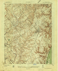
 1936 Vine Grove1936 Print · USGSHardin and Bullitt counties are shown here during a period of massive military expansion before the mid-century. Researchers can trace the development of Fort Knox alongside established communities like Vine Grove and old rural landmarks like Stovall Chapel or the Glenbeddis Sch.
 - 1937 Map of Jeffersonville
 1937 Jeffersonville1937 Print · USGSJeffersonville and the northern banks of the Ohio River appear here in the late 1930s, documenting a landscape shaped by early industry and river trade. Researchers can trace the path of the Indiana Railroad (Electric Line) and locate landmarks like Asbury Chapel and Walnut Ridge Cemetery.
 - 1937 Map of Charlestown
 1937 Charlestown1937 Print · USGSClark County during the late thirties shows a landscape of rail-connected towns and rural institutions. Genealogists and historians can trace Crab College, the Clark Co Asylum, and family sites like Bottorff Cem and Tunnel Mill.
 - 1939 Map of New Albany
 1939 New Albany1939 Print · USGSThe industrial riverfront of southern Indiana comes alive in this pre-war survey of the Ohio River bend. Genealogists and historians can trace the early footprints of New Albany and Clarksville, locating the County Infirmary, St Marys Cem, and the massive Jeffersonville Military Reservation.
End of results
Showing maps 1-5 of 5
Top cities near Louisville
- Jeffersonville historical maps
- New Albany historical maps
- Jeffersontown historical maps
- Clarksville historical maps
- Shively historical maps
- Mount Washington historical maps
See more
Top neighborhoods of Louisville
- Beechland Beach historical maps
- Glenview Heights historical maps
- Juniper Beach historical maps
- Gulthrie Beach historical maps
- Harrods Creek historical maps
- Riverside Beach historical maps
See more
Frequently asked questions
- What are the different types of historical maps available for Louisville?
- What is the oldest map of Louisville?
- Where can I purchase historical maps of Louisville for my home or office?
- Where can I download high-res historical maps of Louisville?
- Are there historical topographic maps available for Louisville?
- Is there historical aerial imagery available for Louisville?
- Where are historical maps of Louisville sourced from?