Old Maps of Louisville, Kentucky for Genealogy
Trace your family roots with 175 historic maps of Louisville. These high-res maps reveal old neighborhoods, homesites, landmarks, and streets — helping you uncover where your ancestors lived and how the area evolved over time.
- Explore historic neighborhoods: Identify where your relatives may have lived in the 1800s or 1900s.
- Compare maps over time: Trace the changes in streets, buildings, and landmarks for multi-generational research.
- Perfect for genealogy & ancestry research: Used by family historians and researchers to map out lineage and migration.
These maps are an incredible resource for exploring your personal connection to Louisville's past.
Louisville, KY maps
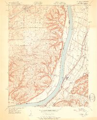
(175)- 1905 Map of Prospect, 1962 Print
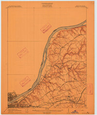
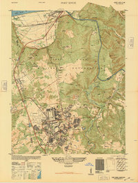
 1905 Prospect1962 Print · USGSThe Ohio River corridor north of Louisville comes alive in the early 1900s, showing a landscape of river landings and new electric railways. Researchers can find old landmarks like the Lakeland Asylum, the Kentucky Military Institute, and the Antioch Church.
 - 1907 Map of Louisville
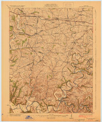
 1907 Louisville1907 Print · USGSLouisville and the rolling hills of Jefferson and Bullitt counties are captured here in the early 1900s. Researchers can trace ancestral connections through sites like Cave Hill Cemetery, Pleasant Grove Schoolhouse, and the river crossing at Bells Mill Ford.3 unique versions available
 - 1909 Map of Kosmosdale
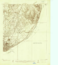
 1909 Kosmosdale1909 Print · USGSSouthwest of Louisville at the turn of the century, the river valley meets the steep slopes of Muldraughs Hill. Researchers can trace early rural life through several family-named schoolhouses and small settlements like Kosmosdale, Valley Sta, and the County Infirmary.
 - 1912 Map of Prospect
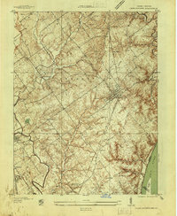
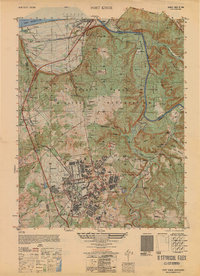
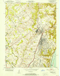
 1912 Prospect1912 Print · USGSThe northeastern outskirts of Louisville and the riverbanks of the Ohio River appear here in the early twentieth century. Researchers can trace the development of suburban settlements like Anchorage and St Matthews or locate the sprawling grounds of the Lakeland Asylum.3 unique versions available
 - 1912 Map of Kosmosdale
 1912 Kosmosdale1912 Print · USGSThe Ohio River valley and the Kentucky Knobs come alive in this pre-war survey, showing the expansion of southern Louisville and the rural hills of Jefferson and Bullitt counties. Researchers can locate vanished landmarks like Locust Point P.O. and the County Infirmary, or trace the old riverboat stops at Stewarts Landing.4 unique versions available
 - 1929 Map of Taylorsville
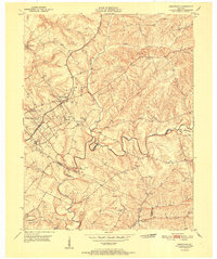
 1929 Taylorsville1929 Print · USGSSpencer and Shelby counties are shown here in the late twenties, where the Salt River meets a network of early rail and pike roads. Genealogists can trace family lands near Shiloh Church, Beechwood School, and the settlement of Simpsonville.2 unique versions available
 - 1932 Map of La Grange
 1932 La Grange1932 Print · USGSThe Bluegrass region in the early thirties reveals a landscape defined by the Louisville and Nashville Railroad and the Ohio River. Genealogists can locate family landmarks like Henrysville Cemetery and several rural schoolhouses including Sweeney Sch.
 - 1936 Map of Vine Grove
 1936 Vine Grove1936 Print · USGSHardin and Bullitt counties are shown here during a period of massive military expansion before the mid-century. Researchers can trace the development of Fort Knox alongside established communities like Vine Grove and old rural landmarks like Stovall Chapel or the Glenbeddis Sch.
 - 1937 Map of Jeffersonville
 1937 Jeffersonville1937 Print · USGSJeffersonville and the northern banks of the Ohio River appear here in the late 1930s, documenting a landscape shaped by early industry and river trade. Researchers can trace the path of the Indiana Railroad (Electric Line) and locate landmarks like Asbury Chapel and Walnut Ridge Cemetery.
 - 1937 Map of Charlestown
 1937 Charlestown1937 Print · USGSClark County during the late thirties shows a landscape of rail-connected towns and rural institutions. Genealogists and historians can trace Crab College, the Clark Co Asylum, and family sites like Bottorff Cem and Tunnel Mill.
 - 1939 Map of New Albany
 1939 New Albany1939 Print · USGSThe industrial riverfront of southern Indiana comes alive in this pre-war survey of the Ohio River bend. Genealogists and historians can trace the early footprints of New Albany and Clarksville, locating the County Infirmary, St Marys Cem, and the massive Jeffersonville Military Reservation.
 - 1943 Map of Vine Grove
 1943 Vine Grove1943 Print · USGSHardin and Meade Counties appear here during a period of massive mid-century growth at Fort Knox. Genealogists can trace family homesteads near landmarks like Stovall Chapel, Red Hill, and the many rural schools including Hays Sch and Deckard Sch.
 - 1946 Map of Fort Knox
 1946 Fort Knox1946 Print · USGSFort Knox and the surrounding Kentucky riverlands are captured just after the war as the military installation reached its modern maturity. Researchers can trace the layout of Godman Field, locate the famous Bullion Depository, and find family landmarks like Montgomery Cem or the town of West Point.
 - 1946 Map of Jeffersonville
 1946 Jeffersonville1946 Print · USGSSouthern Indiana sits at a crossroads of river and rail during the mid-1940s, as the industrial grid of Jeffersonville meets the rural Clark Military Grant. Researchers can trace family roots at Walnut Ridge Cem or locate vanished schoolhouses like Lane Sch and Middle Road Sch.2 unique versions available
 - 1946 Map of New Albany
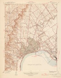 1946 New Albany1946 Print · USGSThe Indiana shoreline of the Ohio River bustles with mid-century activity as railroads and bridges connect New Albany to the south. Researchers can trace historic local sites like Blackiston Mill, the County Infirmary, and Graceland Cem near the Falls of the Ohio.2 unique versions available
 - 1946 Map of Vine Grove, 1959 Print
 1946 Vine Grove1959 Print · USGSMid-century Hardin County is defined by the massive expansion of the Fort Knox Military Reservation and its surrounding rail-and-highway hubs. Researchers can trace dozens of family cemeteries and vanished landmarks like the Woolridge Ferry Bridge, Sherrard Sch, and the community of Pitts Point.
 - 1950 Map of Fort Knox
 1950 Fort Knox1950 Print · USGSFort Knox and its surroundings in the years following the war show a landscape transformed by military necessity and river valley geography. Researchers can trace the layout of the US Bullion Depository and Godman Field alongside older communities like West Point and Goldville.
 - 1950 Map of Charlestown, 1952 Print
 1950 Charlestown1952 Print · USGSSouthern Indiana was undergoing a major industrial and military transformation at mid-century as the Cold War intensified. Local researchers can trace the massive Indiana Arsenal, the path of the Pennsylvania RR, and family history at St Michael Ch or Pleasant Grove Cem.
 - 1950 Map of New Albany, 1955 Print
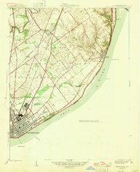
 1950 New Albany1955 Print · USGSThe riverfront communities of Indiana and Kentucky meet at the Ohio River during a mid-century period of heavy industry and rail expansion. Genealogists and local historians can locate early burial grounds like Portland Cem, institutional landmarks such as the County Infirmary, and long-standing schools including McCulloch Sch.
 - 1950 Map of Kosmosdale, 1959 Print
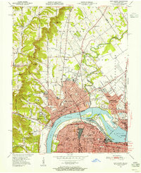
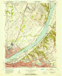
 1950 Kosmosdale1959 Print · USGSGreater Louisville and the Ohio River valley are captured here at mid-century, showing the city's industrial south side meeting rural river towns. Genealogists and historians can trace family locations through Lanesville Cem, the Waverly Hills Sanatorium, and Churchill Downs.
 - 1951 Map of Anchorage
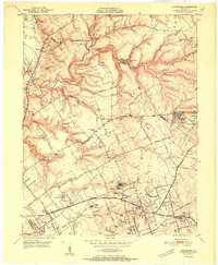 1951 Anchorage1951 Print · USGSJefferson and Oldham Counties appear here in the early fifties, showing a landscape defined by institutional campuses and rail-centered towns. Genealogists and historians can trace Ormsby Village, Berrytown, and the Kentucky Military Institute along the Louisville and Nashville Railroad.
 - 1951 Map of Crestwood
 1951 Crestwood1951 Print · USGSThe railroad corridor between Oldham and Jefferson counties is well-established in the early fifties, centering on the growth of Crestwood and Pewee Valley. Researchers can locate historic institutions like the Pewee Valley Sanitarium and State Prison, or trace old family land near Pleasant Hill Cem and Glenarm.
 - 1951 Map of Kosmosdale
 1951 Kosmosdale1951 Print · USGSThe Ohio River valley south of Louisville was a busy corridor of rail and road commerce in the early fifties. Genealogists and historians can trace local landmarks like Kosmosdale Sch, Mill Creek Cem, and the boundaries of the Fort Knox Military Reservation.2 unique versions available
 - 1951 Map of Jeffersonville
 1951 Jeffersonville1951 Print · USGSThe Ohio River corridor near the Falls was a bustling hub of mid-century industry and suburban growth just after the war. Local historians can trace the footprints of the Indiana Arsenal, the Big Four RR Bridge, and old family landmarks from Claysburg to St Matthews.
 - 1951 Map of Louisville East
 1951 Louisville East1951 Print · USGSJefferson County is shown in the early fifties as the city reaches outward toward Okolona and Buechel. Researchers can trace old family burial grounds like Evergreen Cemetery and landmark institutions such as Standiford Field and the U S Army Medical Depot.
Showing maps 1-25 of 175
Top cities near Louisville
- Jeffersonville historical maps
- New Albany historical maps
- Jeffersontown historical maps
- Clarksville historical maps
- Shively historical maps
- Mount Washington historical maps
See more
Top neighborhoods of Louisville
- Beechland Beach historical maps
- Glenview Heights historical maps
- Juniper Beach historical maps
- Gulthrie Beach historical maps
- Harrods Creek historical maps
- Riverside Beach historical maps
See more
Frequently asked questions
- What are the different types of historical maps available for Louisville?
- What is the oldest map of Louisville?
- Where can I purchase historical maps of Louisville for my home or office?
- Where can I download high-res historical maps of Louisville?
- Are there historical topographic maps available for Louisville?
- Is there historical aerial imagery available for Louisville?
- Where are historical maps of Louisville sourced from?