1960s Maps of Laurel County, Kentucky
Explore 9 historic maps of Laurel County from the 1960s. These maps offer a rare glimpse into what life looked like during the 1960s — showing old roads, neighborhoods, homes, and landmarks that have changed or disappeared over time.
Whether you're researching your family's past, planning a metal detecting trip, or studying how Laurel County's landscape evolved across the 1960s, these high-resolution maps are a powerful tool for exploring the history of this region.
- Focus on a specific era: All maps on this page are from the 1960s, giving you a focused view of this time period.
- See what’s changed: Compare century-old streets, trails, and buildings to today's modern landscape using overlays and satellite layers.
- Research with precision: Use these maps for genealogy, historical research, land use analysis, or educational projects.
- View, download, or print: Maps are fully viewable online in high resolution, and can be downloaded or printed for your own records.
Start exploring Laurel County's history through authentic maps from the 1960s. This is your window into the past.
Laurel County, KY maps
(9)- 1960 Map of Jenkins
 1960 Jenkins1960 Print · USGSEastern Kentucky and the West Virginia borderlands are captured at a mid-century peak of the coal and rail era. Trace the industrial corridors of the Chesapeake and Ohio RR through mountain hubs like Hazard and Jenkins.
 - 1960 Map of Johnson City
 1960 Johnson City1960 Print · USGSUpper East Tennessee and the surrounding tri-state area are shown in the mid-fifties during the height of the TVA reservoir era. Trace the industrial rail lines of the Southern and Louisville and Nashville between Kingsport and Johnson City.
 - 1960 Map of Winchester
 1960 Winchester1960 Print · USGSCentral Kentucky's diverse landscape is shown here at mid-century, from the bluegrass plains to the rugged Pottsville Escarpment. Genealogists and historians can trace the rail-and-river network connecting towns like Bardstown and Stanford alongside landmarks like Lake Cumberland.
 - 1961 Map of Lily, 1963 Print
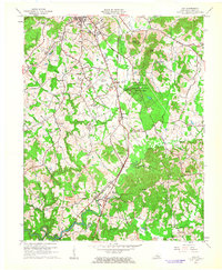 1961 Lily1963 Print · USGSLaurel County during the early sixties shows a landscape where historic pioneer routes meet a growing industrial and aviation hub. You can trace family roots at Whittaker Cem, explore the layout of Sublimity City, or locate the many Strip Mines and rural schools like Valley Grove Sch.
 - 1961 Map of Corbin, 1963 Print
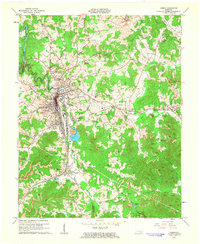 1961 Corbin1963 Print · USGSCorbin and its surrounding coal-country settlements are shown here during a period of heavy industrial activity in the early sixties. Researchers can trace the Louisville and Nashville rail lines to old station sites like Siler Sta, or locate family landmarks such as Resthaven Cem and Wilton Lake.
 - 1963 Map of Johnson City
 1963 Johnson City1963 Print · USGSThe Tri-Cities and the surrounding Appalachian ridges are shown in detail during the early sixties, highlighting the era's vital rail and river networks. Genealogists and historians can trace the routes of the Clinchfield RR and locate settlements from Rogersville to Elizabethton.
 - 1969 Map of Bernstadt, 1971 Print
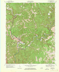
 1969 Bernstadt1971 Print · USGSThe Daniel Boone National Forest and the waters of Wood Creek Lake define this Laurel County landscape in the late sixties. Genealogists can trace family roots through hillside sites like Bernstadt, Colony Sch, and Hazel Patch Cem.3 unique versions available
 - 1969 Map of Livingston, 1971 Print
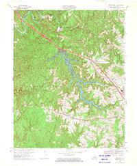
 1969 Livingston1971 Print · USGSThe Rockcastle River corridor in the late sixties shows a landscape where historic transit routes and coal extraction meet. Local historians can trace the Wilderness Road and rail spurs near Livingston, or locate sites like Great Saltpetre Cave and Red Hill Sch.2 unique versions available
 - 1969 Map of London, 1972 Print
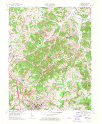 1969 London1972 Print · USGSLaurel County's transition from traditional rail towns to the modern parkway era is evident in the late sixties. Trace family history through Old Salem Cem, White Oak Sch, and the riverside community of McWhorter.2 unique versions available
End of results
Showing maps 1-9 of 9
Top cities of Laurel County
Frequently asked questions
- What are the different types of historical maps available for Laurel County?
- What is the oldest map of Laurel County?
- Where can I purchase historical maps of Laurel County for my home or office?
- Where can I download high-res historical maps of Laurel County?
- Are there historical topographic maps available for Laurel County?
- Is there historical aerial imagery available for Laurel County?
- Where are historical maps of Laurel County sourced from?