1970s Maps of Lawrence County, Kentucky
Explore 8 historic maps of Lawrence County from the 1970s. These maps offer a rare glimpse into what life looked like during the 1970s — showing old roads, neighborhoods, homes, and landmarks that have changed or disappeared over time.
Whether you're researching your family's past, planning a metal detecting trip, or studying how Lawrence County's landscape evolved across the 1970s, these high-resolution maps are a powerful tool for exploring the history of this region.
- Focus on a specific era: All maps on this page are from the 1970s, giving you a focused view of this time period.
- See what’s changed: Compare century-old streets, trails, and buildings to today's modern landscape using overlays and satellite layers.
- Research with precision: Use these maps for genealogy, historical research, land use analysis, or educational projects.
- View, download, or print: Maps are fully viewable online in high resolution, and can be downloaded or printed for your own records.
Start exploring Lawrence County's history through authentic maps from the 1970s. This is your window into the past.
Lawrence County, KY maps
(8)- 1970 Map of Willard, 1972 Print
 1970 Willard1972 Print · USGSEastern Kentucky's hill country at the start of the 1970s shows a landscape of ridge-top settlements and coal-country hollows. Genealogists and historians can locate family landmarks like Hensley Cem and Kitchen Cem, or trace the mining history near Willard and Jeriel.2 unique versions available
 - 1971 Map of Boltsfork, 1972 Print
 1971 Boltsfork1972 Print · USGSThe Boyd and Lawrence County borderlands appear in the early seventies, showcasing a landscape of ridge-top trails and valley settlements. Researchers can trace the foundations of Boltsfork and Garner or locate family landmarks like Musick Chapel and Mt Zion Ch.2 unique versions available
 - 1971 Map of Sitka, 1973 Print
 1971 Sitka1973 Print · USGSThe hollows of Johnson and Lawrence Counties were a hub of energy production in the early seventies. Genealogists and historians can trace family locations near Sitka, Stambaugh, and Davisville, or locate specific sites like Sugar Grove Ch and the Sparks Cem.2 unique versions available
 - 1971 Map of Adams, 1973 Print
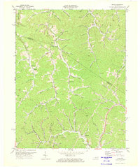
 1971 Adams1973 Print · USGSLawrence County, Kentucky, is shown here in the early 1970s as a landscape of deep hollows and active coal mining. Local researchers can trace family landmarks and rural hubs such as Beech Farm, Carters Chapel, and the Lower Twin Branch School.3 unique versions available
 - 1971 Map of Louisa, 1973 Print
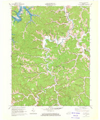
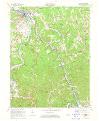 1971 Louisa1973 Print · USGSThe tri-state border region of Kentucky and West Virginia is captured here in the early seventies as the river-and-rail economy shaped the valley. Genealogists can trace family names at Greenlawn Cem or McClure Cem, and locate rural landmarks like Old Pleasant Ch and the hamlet of Saltpetre.4 unique versions available
 - 1971 Map of Fallsburg, 1973 Print
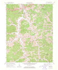
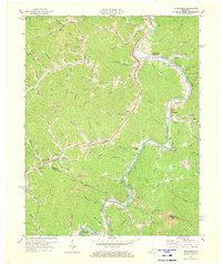
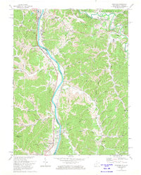
 1971 Fallsburg1973 Print · USGSIn the early 1970s, the rugged borderlands of Lawrence County were a complex network of rail lines and creek-side settlements. Researchers can trace the legacy of family homesteads and industry through labels for the Covered Bridge, Garrett Chapel, and the coal-and-oil works of the Big Sandy River valley.4 unique versions available
 - 1971 Map of Richardson, 1973 Print
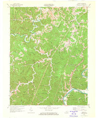
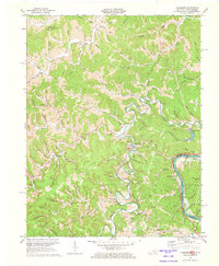
 1971 Richardson1973 Print · USGSThe Levisa Fork valley in the early 1970s shows a landscape shaped by the coal industry and the Chesapeake and Ohio railroad. Researchers can trace rural lineages through settlements like Richardson, Charley, and Lowmansville, alongside numerous Cemeteries and local landmarks like Chestnut Grove Ch.2 unique versions available
 - 1972 Map of Burnaugh, 1974 Print
 1972 Burnaugh1974 Print · USGSThe river and rail corridor of the Big Sandy River defines this 1970s borderland between Kentucky and West Virginia. Genealogists and local historians can trace family locations through numerous sites like Lockwood Cem, Miller Chapel, and the riverside rail stops at Burnaugh.3 unique versions available
End of results
Showing maps 1-8 of 8
Top cities of Lawrence County
Frequently asked questions
- What are the different types of historical maps available for Lawrence County?
- What is the oldest map of Lawrence County?
- Where can I purchase historical maps of Lawrence County for my home or office?
- Where can I download high-res historical maps of Lawrence County?
- Are there historical topographic maps available for Lawrence County?
- Is there historical aerial imagery available for Lawrence County?
- Where are historical maps of Lawrence County sourced from?