1960s Maps of Marshall County, Kentucky
Explore 8 historic maps of Marshall County from the 1960s. These maps offer a rare glimpse into what life looked like during the 1960s — showing old roads, neighborhoods, homes, and landmarks that have changed or disappeared over time.
Whether you're researching your family's past, planning a metal detecting trip, or studying how Marshall County's landscape evolved across the 1960s, these high-resolution maps are a powerful tool for exploring the history of this region.
- Focus on a specific era: All maps on this page are from the 1960s, giving you a focused view of this time period.
- See what’s changed: Compare century-old streets, trails, and buildings to today's modern landscape using overlays and satellite layers.
- Research with precision: Use these maps for genealogy, historical research, land use analysis, or educational projects.
- View, download, or print: Maps are fully viewable online in high resolution, and can be downloaded or printed for your own records.
Start exploring Marshall County's history through authentic maps from the 1960s. This is your window into the past.
Marshall County, KY maps
(8)- 1961 Map of Paducah
 1961 Paducah1961 Print · USGSThe Lower Ohio Valley at mid-century is a landscape defined by its great rivers and newly formed reservoirs. Researchers can trace the riverfronts of Paducah and Metropolis, or locate smaller settlements like Old Shawneetown and Cave in Rock along the banks.2 unique versions available
 - 1964 Map of Paducah
 1964 Paducah1964 Print · USGSThe river-and-rail corridor of Southern Illinois and Western Kentucky is captured here during the height of the mid-century industrial era. Genealogists and researchers can trace local landmarks across several counties, from the rail yards of Paducah to the waters of Crab Orchard Lake and Kentucky Reservoir.2 unique versions available
 - 1967 Map of Fenton, 1968 Print
 1967 Fenton1968 Print · USGSWestern Kentucky’s peninsula between the rivers is captured here in the late sixties as the reservoir system matured. Genealogists and historians can locate Fenton, the Egger Ferry Bridge, and family burial grounds like Jenny Ridge Cem.3 unique versions available
 - 1967 Map of Birmingham Point, 1968 Print
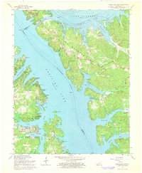 1967 Birmingham Point1968 Print · USGSIn the late sixties, this area between the newly formed Kentucky Lake and Lake Barkley reveals a landscape transformed by water. Researchers can trace the original location of Birmingham, find family burial grounds like Demumbers Cem, and follow the route of The Trace.3 unique versions available
 - 1969 Map of Dexter, 1970 Print
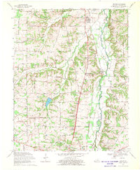 1969 Dexter1970 Print · USGSCalloway County is captured here in the late sixties as a landscape of small rail-side hamlets and tight-knit country congregations. Genealogists can locate family-named landmarks and community hubs like Coley Campground Ch, the Almo Sch, and the settlement of Penny.2 unique versions available
 - 1969 Map of Briensburg, 1970 Print
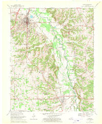
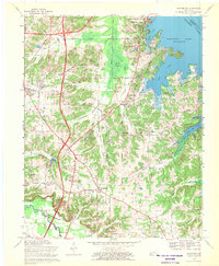 1969 Briensburg1970 Print · USGSThe Tennessee River shoreline of Marshall County is captured here during the late sixties as modern highways reshaped the local economy. Researchers can trace ancestral sites at Birmingham Cem and McNatt Cem or locate landmarks like the Drive-in Theater.
 - 1969 Map of Hardin, 1970 Print
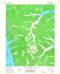
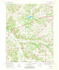
 1969 Hardin1970 Print · USGSMarshall County's river valley comes alive in the late sixties as the Louisville and Nashville rail line connects Benton and Hardin. Genealogists can trace family landmarks like Union Hill Ch and old crossings at Washburn Ford.2 unique versions available
 - 1969 Map of Oak Level, 1971 Print
 1969 Oak Level1971 Print · USGSSouthwestern Marshall County in the late sixties shows a traditional farming landscape being reshaped by modern infrastructure. Genealogists and local historians can trace family-named sites like Dowdy Cemetery and communities such as Oak Level, Brewers, and Vanzora.2 unique versions available
End of results
Showing maps 1-8 of 8
Top cities of Marshall County
Frequently asked questions
- What are the different types of historical maps available for Marshall County?
- What is the oldest map of Marshall County?
- Where can I purchase historical maps of Marshall County for my home or office?
- Where can I download high-res historical maps of Marshall County?
- Are there historical topographic maps available for Marshall County?
- Is there historical aerial imagery available for Marshall County?
- Where are historical maps of Marshall County sourced from?