1960s Maps of McCracken County, Kentucky
Explore 5 historic maps of McCracken County from the 1960s. These maps offer a rare glimpse into what life looked like during the 1960s — showing old roads, neighborhoods, homes, and landmarks that have changed or disappeared over time.
Whether you're researching your family's past, planning a metal detecting trip, or studying how McCracken County's landscape evolved across the 1960s, these high-resolution maps are a powerful tool for exploring the history of this region.
- Focus on a specific era: All maps on this page are from the 1960s, giving you a focused view of this time period.
- See what’s changed: Compare century-old streets, trails, and buildings to today's modern landscape using overlays and satellite layers.
- Research with precision: Use these maps for genealogy, historical research, land use analysis, or educational projects.
- View, download, or print: Maps are fully viewable online in high resolution, and can be downloaded or printed for your own records.
Start exploring McCracken County's history through authentic maps from the 1960s. This is your window into the past.
McCracken County, KY maps
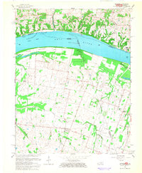
(5)- 1961 Map of Paducah
 1961 Paducah1961 Print · USGSThe Lower Ohio Valley at mid-century is a landscape defined by its great rivers and newly formed reservoirs. Researchers can trace the riverfronts of Paducah and Metropolis, or locate smaller settlements like Old Shawneetown and Cave in Rock along the banks.2 unique versions available
 - 1964 Map of Paducah
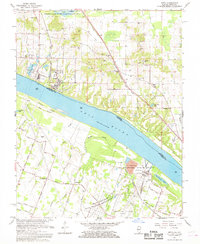
 1964 Paducah1964 Print · USGSThe river-and-rail corridor of Southern Illinois and Western Kentucky is captured here during the height of the mid-century industrial era. Genealogists and researchers can trace local landmarks across several counties, from the rail yards of Paducah to the waters of Crab Orchard Lake and Kentucky Reservoir.2 unique versions available
 - 1966 Map of Bandana, 1968 Print
 1966 Bandana1968 Print · USGSLife along the Ohio River in the 1960s centered on riverside landings and small agricultural hubs like Bandana and Monkeys Eyebrow. Researchers can trace family history through local landmarks like Ragland Sch and numerous cemeteries including Miles Cem and Hitchcock Cem.
 - 1967 Map of Joppa, 1968 Print
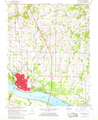
 1967 Joppa1968 Print · USGSThe Illinois-Kentucky borderlands at the Ohio River reveal a landscape of massive industrial energy and quiet rural settlements. Researchers can locate family cemeteries like Kirkendall Cem and trace old rail lines serving the Shawnee Steam Plant (TVA).2 unique versions available
 - 1967 Map of Metropolis, 1968 Print
 1967 Metropolis1968 Print · USGSMetropolis and the Ohio River shoreline are shown in detail during the late 1960s as industrial and civic infrastructure expanded. Researchers can trace family roots through numerous rural sites like Upper Salem Ch, Bumgardner Cem, and Lincoln Sch.
End of results
Showing maps 1-5 of 5
Top cities of McCracken County
Frequently asked questions
- What are the different types of historical maps available for McCracken County?
- What is the oldest map of McCracken County?
- Where can I purchase historical maps of McCracken County for my home or office?
- Where can I download high-res historical maps of McCracken County?
- Are there historical topographic maps available for McCracken County?
- Is there historical aerial imagery available for McCracken County?
- Where are historical maps of McCracken County sourced from?