1980s Maps of McCracken County, Kentucky
Explore 13 historic maps of McCracken County from the 1980s. These maps offer a rare glimpse into what life looked like during the 1980s — showing old roads, neighborhoods, homes, and landmarks that have changed or disappeared over time.
Whether you're researching your family's past, planning a metal detecting trip, or studying how McCracken County's landscape evolved across the 1980s, these high-resolution maps are a powerful tool for exploring the history of this region.
- Focus on a specific era: All maps on this page are from the 1980s, giving you a focused view of this time period.
- See what’s changed: Compare century-old streets, trails, and buildings to today's modern landscape using overlays and satellite layers.
- Research with precision: Use these maps for genealogy, historical research, land use analysis, or educational projects.
- View, download, or print: Maps are fully viewable online in high resolution, and can be downloaded or printed for your own records.
Start exploring McCracken County's history through authentic maps from the 1980s. This is your window into the past.
McCracken County, KY maps
(13)- 1982 Map of Elva
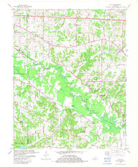 1982 Elva1982 Print · USGSWestern Kentucky in the early eighties reveals a river-linked landscape of family homesteads and small country parishes. Genealogists can trace local roots through Wallace Cem, Feezor Cem, and old church sites like Oakland Ch.
 - 1982 Map of Melber, 1983 Print
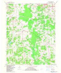
 1982 Melber1983 Print · USGSThe rural borderlands of McCracken and Graves counties are captured here in the early eighties, showcasing a landscape of family farms and creek valleys. Researchers can locate numerous family burial grounds and country churches like St Johns Cem & Ch, Diggs Chapel, and Hunt Cem.
 - 1982 Map of Little Cypress, 1983 Print
 1982 Little Cypress1983 Print · USGSThe confluence of the Ohio and Tennessee Rivers in the early 1980s reveals a landscape shaped by river commerce and rail. Researchers can trace the Illinois Central Gulf Railroad past Kincaid Mounds and old community landmarks like Vaughn Chapel and Possum Trot.
 - 1982 Map of Symsonia, 1983 Print
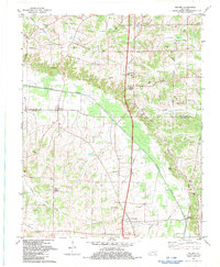
 1982 Symsonia1983 Print · USGSThe borderlands of Graves and McCracken County come to life in this early 1980s survey of the Kentucky countryside. Genealogists can trace family names at Boaz Cem and McClure Cem while locating old centers like Hardmoney and Symsonia.
 - 1982 Map of Paducah West, 1983 Print
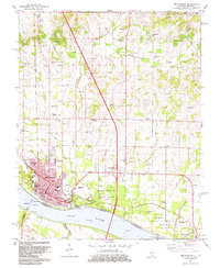
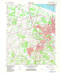 1982 Paducah West1983 Print · USGSMcCracken County in the early eighties shows the suburban growth of Paducah along the Ohio River. Researchers can trace old family sites at Highland Cem and Mount Kenton Cemetery or locate the West Paducah rail stop.
 - 1982 Map of Paducah East, 1983 Print
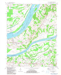
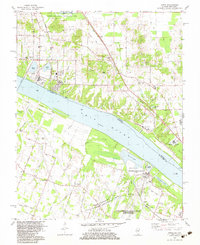
 1982 Paducah East1983 Print · USGSWestern Kentucky's riverfront culture and rail industry are on full display in this early 1980s survey of the river confluence. Researchers can trace historic family plots and community centers like Herzog Cem, Rocky Ford Ch, and the Whiteside Sch.
 - 1982 Map of Joppa, 1983 Print
 1982 Joppa1983 Print · USGSThe Illinois-Kentucky border comes alive in the early 1980s, showcasing the industrial riverfront near Joppa. Genealogists and historians can trace family roots through landmarks like Kirkendall Cem, Maple Grove Sch, and the riverside Rossington settlement.
 - 1982 Map of Bandana, 1983 Print
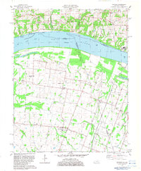 1982 Bandana1983 Print · USGSNear the confluence of the Ohio River in West Kentucky, this early 1980s survey captures a landscape of small agricultural settlements and river bottoms. Researchers can trace family history through landmarks like Monkeys Eyebrow, Herrin Cem, and Providence Ch.
 - 1982 Map of Metropolis, 1983 Print
 1982 Metropolis1983 Print · USGSMetropolis and the Ohio River shoreline are captured here in the early eighties, showing the city's growth alongside historic riverfront landmarks. Researchers can trace family plots at Odd Fellows Cem or explore the grounds of Fort Massac State Park and Lock and Dam No 52.2 unique versions available
 - 1984 Map of Paducah, 1986 Print
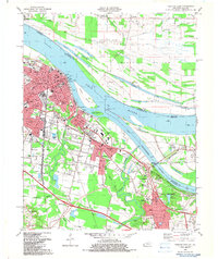
 1984 Paducah1986 Print · USGSThe river-driven economy of western Kentucky and southern Illinois is captured here in the mid-eighties, showing the massive impact of the Kentucky Lake and Lake Barkley reservoirs. Genealogists and historians can trace rail lines like the Illinois Central Gulf RR and explore sites from Fort Massac State Park to the Kentucky State Penitentiary.
 - 1986 Map of Murray
 1986 Murray1986 Print · USGSWestern Kentucky in the mid-1980s reveals a landscape defined by the Tennessee and Cumberland rivers. Genealogists and historians can trace rail-town development along the Illinois Central Gulf RR and find family-named locations like Dukedom and Water Valley.2 unique versions available
 - 1986 Map of Paducah, 1987 Print
 1986 Paducah1987 Print · USGSThe tri-river confluence of the Ohio, Tennessee, and Cumberland rivers is captured here in the mid-1980s during a period of established river power and industry. Researchers can trace local heritage through landmarks like Friendship Church, the Smithland Locks and Dam, and the Illinois Central Gulf RR.
 - 1987 Map of Paducah, 1988 Print
 1987 Paducah1988 Print · USGSThe Lower Ohio Valley and the Illinois Ozarks come alive in this late twentieth-century regional survey. Genealogists and local historians can trace river-town roots and state park landmarks from Metropolis to Cape Girardeau and Trail of Tears State Park.
End of results
Showing maps 1-13 of 13
Top cities of McCracken County
Frequently asked questions
- What are the different types of historical maps available for McCracken County?
- What is the oldest map of McCracken County?
- Where can I purchase historical maps of McCracken County for my home or office?
- Where can I download high-res historical maps of McCracken County?
- Are there historical topographic maps available for McCracken County?
- Is there historical aerial imagery available for McCracken County?
- Where are historical maps of McCracken County sourced from?