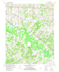
1982 Map of Elva
USGS Topo · Published 1982About this map
Clarks River anchors this landscape in western Kentucky, winding through a complex network of wetlands and riverine features like Steam Mill Bend and the Milliken Swamp. The mapping shows a persistent rural pattern of family-named landmarks and country churches, such as Oakland Ch and New Union Ch, scattered around the small settlements of Sharpe, Elva, and Palma.
Find a feature on this map
71 named features on this map. Tap any name to fly to it.
Don’t see what you’re looking for? This feature index may not catch every label — zoom into the map to look around manually.
Map Details
Editions of this 1982 Elva Map
This is the sole edition of this map. No revisions or reprints were ever made.
Other maps of this area

1926 · Paducah
USGS Topo · 1:62,500

1929 · Smithland
USGS Topo · 1:62,500

1929 · Paducah
USGS Topo · 1:62,500

1936 · Paducah
USGS Topo · 1:24,000

1936 · Oak Level
USGS Topo · 1:24,000

1936 · Elva
USGS Topo · 1:24,000

1936 · Hardin
USGS Topo · 1:24,000

1936 · Smithland
USGS Topo · 1:48,000

1936 · Symsonia
USGS Topo · 1:24,000

1936 · Benton
USGS Topo · 1:48,000