1950s Maps of McCracken County, Kentucky
Explore 20 historic maps of McCracken County from the 1950s. These maps offer a rare glimpse into what life looked like during the 1950s — showing old roads, neighborhoods, homes, and landmarks that have changed or disappeared over time.
Whether you're researching your family's past, planning a metal detecting trip, or studying how McCracken County's landscape evolved across the 1950s, these high-resolution maps are a powerful tool for exploring the history of this region.
- Focus on a specific era: All maps on this page are from the 1950s, giving you a focused view of this time period.
- See what’s changed: Compare century-old streets, trails, and buildings to today's modern landscape using overlays and satellite layers.
- Research with precision: Use these maps for genealogy, historical research, land use analysis, or educational projects.
- View, download, or print: Maps are fully viewable online in high resolution, and can be downloaded or printed for your own records.
Start exploring McCracken County's history through authentic maps from the 1950s. This is your window into the past.
McCracken County, KY maps
(20)- 1950 Map of Paducah
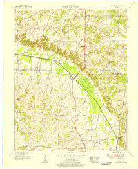
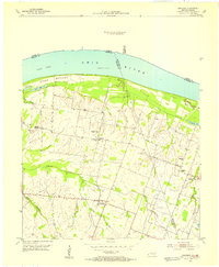
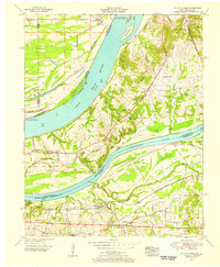
 1950 Paducah1950 Print · USGSThe confluence of the great midwestern rivers defines this mid-century landscape at the intersection of Illinois, Kentucky, and Missouri. Genealogists and historians can trace the rail-and-river economy through the hubs of Paducah, Cairo, and Metropolis or locate family roots near the Wildcat Hills.
 - 1951 Map of Melber, 1956 Print
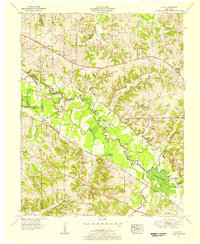
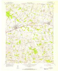
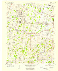
 1951 Melber1956 Print · USGSThe rural borderlands of Graves and McCracken Counties come into focus in this early 1950s study of the western Kentucky landscape. Genealogists can trace family names across dozens of sites like Tittsworth Cem and Allcock Cem, or locate rural landmarks like Diggs Chapel and the Illinois Central rail line.2 unique versions available
 - 1951 Map of Elva, 1956 Print
 1951 Elva1956 Print · USGSWestern Kentucky's rural river bottoms and early highway corridors are captured here in the early fifties. Genealogists can trace family landmarks and community centers such as Bethlehem Ch, Belton Cem, and the crossing at McCoy Ford Bridge.2 unique versions available
 - 1951 Map of Symsonia, 1956 Print
 1951 Symsonia1956 Print · USGSWestern Kentucky at the start of the fifties shows a landscape of river forks and small settlements like Symsonia and Hardmoney. Genealogists can trace family names through landmarks like Thompson Cem, Neece Chapel, and the Freemont Sch.2 unique versions available
 - 1951 Map of Hickory, 1957 Print
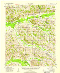
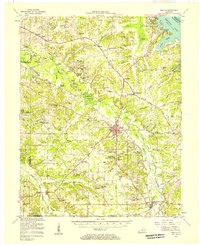
 1951 Hickory1957 Print · USGSIn the early 1950s, this area of Graves and McCracken County was a patchwork of small tobacco farms and rail-stop towns. Researchers can locate hundreds of family sites, from the Clay Pits near Hickory to remote landmarks like Neece Chapel and Old Casey Bridge.
 - 1952 Map of Fancy Farm, 1958 Print
 1952 Fancy Farm1958 Print · USGSWestern Kentucky's rural landscapes are documented here in the early fifties, showing the tight-knit farming communities of Graves and Carlisle counties. Trace family history through local landmarks like Fancy Farm, St Charles Sch, and Milburn Cem.
 - 1953 Map of Paducah East, 1956 Print
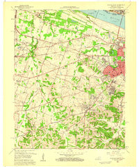
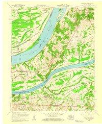
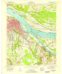 1953 Paducah East1956 Print · USGSPaducah thrived at the strategic meeting of the Ohio and Tennessee Rivers during the early fifties, serving as a bustling railway and maritime center. Researchers can trace the mid-century city grid and outlying landmarks like Augusta Tilghman High School, Owens Island, and the sprawling Illinois Central Railroad yards.
 - 1954 Map of Paducah
 1954 Paducah1954 Print · USGSSouthern Illinois and Western Kentucky intersect at the great river confluences during this mid-century era of rail and river industry. Genealogists and historians can trace family roots and commerce through river towns like Cairo, Metropolis, and Golconda, or along the tracks of the Illinois Central Railroad.2 unique versions available
 - 1954 Map of Metropolis, 1955 Print
 1954 Metropolis1955 Print · USGSThe Ohio River borderland comes into focus in the mid-1950s, highlighting the essential river-and-rail infrastructure of the era. Researchers can trace the path of the Illinois Central Railroad and locate the historic Lock and Dam No 52 near Massac Creek.
 - 1954 Map of Paducah West, 1955 Print
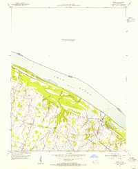
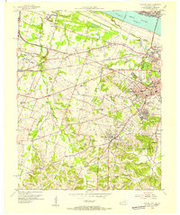 1954 Paducah West1955 Print · USGSWestern McCracken County during the mid-fifties shows the city of Paducah expanding into the surrounding countryside. Genealogists can locate family sites at the Mount Kenton Cemetery, Massac Cem, and the Palestine Ch.
 - 1954 Map of Bandana, 1955 Print
 1954 Bandana1955 Print · USGSThe riverfront and farming communities of Ballard County are captured here in the mid-fifties, just south of the Ohio River. Genealogists and historians can trace family locations near Bandana, the uniquely named Monkeys Eyebrow, and Herrin Cem.
 - 1954 Map of La Center, 1955 Print
 1954 La Center1955 Print · USGSWestern Kentucky farming communities thrive along the Illinois Central rail line during the mid-fifties. Genealogists can trace family roots through numerous landmarks like Ballard Memorial Sch and several family burial grounds including Skinner Cem and Pollock Cem.
 - 1954 Map of Joppa, 1955 Print
 1954 Joppa1955 Print · USGSThe Ohio River borderlands in the mid-1950s show a mix of industrial growth and rural tradition. Trace local genealogy and history through landmarks like Rossington, the Shawnee Steam Plant (TVA), and family sites like Brewer Cem and New Liberty Ch.2 unique versions available
 - 1954 Map of Heath, 1955 Print
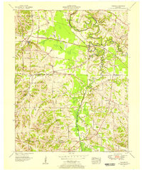
 1954 Heath1955 Print · USGSMcCracken County in the mid-1950s shows a landscape of defense-era growth and deep-rooted rural communities. Researchers can trace the legacy of industrial sites like the Old Kentucky Ordnance Works or find family landmarks at Future City, Carneal Chapel, and Palestine Cem.
 - 1954 Map of Little Cypress, 1956 Print
 1954 Little Cypress1956 Print · USGSThe confluence of the great rivers in Western Kentucky and Southern Illinois is captured here in the mid-1950s. Trace family roots and local industry at Kincaid Mounds, the community of Possum Trot, and along the tracks of the ILLINOIS CENTRAL.
 - 1955 Map of Benton, 1957 Print
 1955 Benton1957 Print · USGSWestern Kentucky in the mid-fifties shows a landscape redefined by the rising waters of Kentucky Lake and the legacy of the Kentucky Dam. Genealogists can trace family names through dozens of rural landmarks like Church Grove Ch, Oak Level Sch, and Steam Mill Bend.
 - 1956 Map of Dyersburg, 1960 Print
 1956 Dyersburg1960 Print · USGSThe Four Rivers region comes alive in the mid-fifties, capturing the intricate borderlands of Tennessee, Kentucky, and Missouri. Genealogists and historians can trace the rail-and-river networks connecting Dyersburg, Caruthersville, and the shoreline of Reelfoot Lake.4 unique versions available
 - 1958 Map of Paducah West, 1959 Print
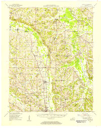
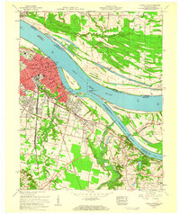
 1958 Paducah West1959 Print · USGSWestern Kentucky’s riverfront and growing suburbs are documented here in the late fifties as the regional economy transitioned. Researchers can trace the development of Lone Oak and Rowlandtown or locate rural sites like Massac Cem and Palestine Ch.2 unique versions available
 - 1958 Map of Paducah East, 1959 Print
 1958 Paducah East1959 Print · USGSThe riverport of Paducah is seen in the late fifties at its bustling confluence with the Tennessee River. Genealogists and local historians can trace the development of Littleville, locate family plots at Allard Cem, or find old school sites like Whittier Sch.3 unique versions available
 - 1958 Map of Little Cypress, 1959 Print
 1958 Little Cypress1959 Print · USGSLivingston and Marshall Counties meet at the river forks in the late fifties, showing a landscape shaped by the Ohio River and Tennessee River. You can trace family roots at Vaughn Chapel or Oak Grove Cem and locate the rail lines through Little Cypress.2 unique versions available
End of results
Showing maps 1-20 of 20
Top cities of McCracken County
Frequently asked questions
- What are the different types of historical maps available for McCracken County?
- What is the oldest map of McCracken County?
- Where can I purchase historical maps of McCracken County for my home or office?
- Where can I download high-res historical maps of McCracken County?
- Are there historical topographic maps available for McCracken County?
- Is there historical aerial imagery available for McCracken County?
- Where are historical maps of McCracken County sourced from?