1960s Maps of Shelby County, Kentucky
Explore 9 historic maps of Shelby County from the 1960s. These maps offer a rare glimpse into what life looked like during the 1960s — showing old roads, neighborhoods, homes, and landmarks that have changed or disappeared over time.
Whether you're researching your family's past, planning a metal detecting trip, or studying how Shelby County's landscape evolved across the 1960s, these high-resolution maps are a powerful tool for exploring the history of this region.
- Focus on a specific era: All maps on this page are from the 1960s, giving you a focused view of this time period.
- See what’s changed: Compare century-old streets, trails, and buildings to today's modern landscape using overlays and satellite layers.
- Research with precision: Use these maps for genealogy, historical research, land use analysis, or educational projects.
- View, download, or print: Maps are fully viewable online in high resolution, and can be downloaded or printed for your own records.
Start exploring Shelby County's history through authentic maps from the 1960s. This is your window into the past.
Shelby County, KY maps
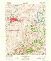
(9)- 1960 Map of Simpsonville
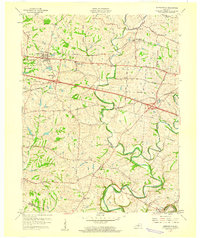 1960 Simpsonville1960 Print · USGSShelby County farmland was defined by its creeks and competing rail lines during the mid-twentieth century. Researchers can trace the development of Simpsonville and Lincoln Ridge or locate family landmarks like Shiloh Ch and Buck Creek Sch.3 unique versions available
 - 1960 Map of Taylorsville
 1960 Taylorsville1960 Print · USGSSpencer County at the start of the 1960s shows a landscape of winding river valleys and tight-knit rural hamlets. Researchers can trace family history through local sites like Little Mount Cem or explore the river-side settings of Taylorsville, Normandy, and Rivals.3 unique versions available
 - 1960 Map of Crestwood, 1961 Print
 1960 Crestwood1961 Print · USGSThe rail towns of the Louisville and Nashville line prosper in the 1960s along the Oldham and Jefferson county border. Genealogists can trace family names at Pleasant Hill Cem, find the St Aloysius Sch, and locate the Pewee Valley Sanatorium.2 unique versions available
 - 1960 Map of Fisherville, 1961 Print
 1960 Fisherville1961 Print · USGSEastern Jefferson County and its neighboring borders are captured here in the early sixties, showing a landscape defined by rail lines and river bends. Genealogists can locate Lincoln Institute at Lincoln Ridge or trace ancestral sites like Bethlehem Ch and Fisherville.
 - 1961 Map of Ballardsville, 1962 Print
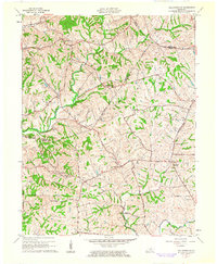 1961 Ballardsville1962 Print · USGSKentucky's rural landscape at the turn of the 1960s reveals a quiet network of farming communities along the Oldham and Shelby county lines. Researchers can trace family sites near Ballardsville School, Hebron Church, and the Olive Branch Cemetery.3 unique versions available
 - 1964 Map of Louisville
 1964 Louisville1964 Print · USGSThe Ohio River valley and Kentucky Bluegrass are captured in the mid-1960s, showing a region balanced between industrial growth and its agrarian roots. Genealogists and historians can trace the development of county seats like Shelbyville and Paris, or locate established institutions such as Georgetown College and Bernheim Forest.
 - 1965 Map of Shelbyville, 1966 Print
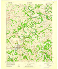
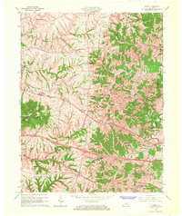
 1965 Shelbyville1966 Print · USGSShelbyville and its surrounding Bluegrass country are captured here in the mid-sixties as the town expanded into neighborhoods like Snow Hill. Genealogists and local historians can trace family plots at Grove Hill Cemetery or locate the rural siding at Hooper near the Southern rail line.5 unique versions available
 - 1965 Map of Waddy, 1967 Print
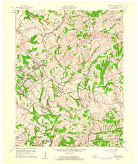
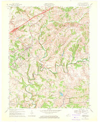
 1965 Waddy1967 Print · USGSShelby County in the mid-1960s is captured here during a period of rural transition along the Southern railroad. Researchers can trace the layout of historic settlements like Waddy and Clay Village or locate family landmarks near Jeptha Knob.4 unique versions available
 - 1969 Map of Crestwood, 1971 Print
 1969 Crestwood1971 Print · USGSThe rail-and-creek landscape of Oldham and Jefferson Counties is captured here in the late sixties as suburban growth meets established rural institutions. Researchers can trace historic sites like the Confederate Cem, Pewee Valley Sanitarium, and the State Prison near Floyds Fork.
End of results
Showing maps 1-9 of 9
Top cities of Shelby County
Frequently asked questions
- What are the different types of historical maps available for Shelby County?
- What is the oldest map of Shelby County?
- Where can I purchase historical maps of Shelby County for my home or office?
- Where can I download high-res historical maps of Shelby County?
- Are there historical topographic maps available for Shelby County?
- Is there historical aerial imagery available for Shelby County?
- Where are historical maps of Shelby County sourced from?