1950s Maps of Trigg County, Kentucky
Explore 28 historic maps of Trigg County from the 1950s. These maps offer a rare glimpse into what life looked like during the 1950s — showing old roads, neighborhoods, homes, and landmarks that have changed or disappeared over time.
Whether you're researching your family's past, planning a metal detecting trip, or studying how Trigg County's landscape evolved across the 1950s, these high-resolution maps are a powerful tool for exploring the history of this region.
- Focus on a specific era: All maps on this page are from the 1950s, giving you a focused view of this time period.
- See what’s changed: Compare century-old streets, trails, and buildings to today's modern landscape using overlays and satellite layers.
- Research with precision: Use these maps for genealogy, historical research, land use analysis, or educational projects.
- View, download, or print: Maps are fully viewable online in high resolution, and can be downloaded or printed for your own records.
Start exploring Trigg County's history through authentic maps from the 1950s. This is your window into the past.
Trigg County, KY maps
(28)- 1950 Map of Rushing Creek, 1953 Print
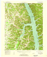
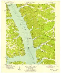 1950 Rushing Creek1953 Print · USGSThe Tennessee and Kentucky borderlands appear here just after the filling of the reservoir, capturing a landscape defined by the new shoreline. Researchers can locate family burial grounds like Rushing Creek Cem and landmarks such as the Lookout Tower and Turkey Creek Ch.5 unique versions available
 - 1950 Map of Mont, 1953 Print
 1950 Mont1953 Print · USGSThe Between the Rivers country of Western Kentucky is documented here in the mid-twentieth century, just before its major federal transformation. Genealogists and historians can trace family sites like Woodson Chapel, Henderson Chapel Cem, and industrial remnants including the Center Furnace (Ruins).2 unique versions available
 - 1950 Map of Fenton, 1953 Print
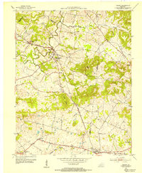
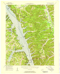
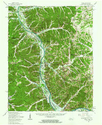
 1950 Fenton1953 Print · USGSThe area of Trigg County between the Tennessee and Cumberland Rivers is shown here in the early fifties. Genealogists can trace family names at McWaters Cem or Newton Cem and locate the old sites of Fenton and Golden Pond.
 - 1950 Map of Caledonia, 1965 Print
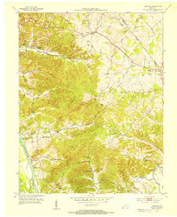
 1950 Caledonia1965 Print · USGSTrigg and Christian Counties are captured in the mid-twentieth century as a landscape of rural schoolhouses, family cemeteries, and karst springs. Researchers can trace the heritage of Caledonia and Julien through landmarks like Binns Mill, Averitt Sch, and Locust Grove Ch.
 - 1951 Map of Caledonia
 1951 Caledonia1951 Print · USGSThe rural borderlands of Trigg and Christian counties are documented here in the early fifties, showing a landscape of sinkhole springs and small crossroads. Genealogists can locate family landmarks like Binns Mill, Locust Grove Ch, and the Old Presbyterian Cem.
 - 1951 Map of Model, 1953 Print
 1951 Model1953 Print · USGSThe Kentucky-Tennessee state line follows the ridge tops and river bends of the 1950s Cumberland Valley. Genealogists can trace family names through dozens of hilltop burial sites like Bethlehem Cem and rural centers such as Model and Tobaccoport.
 - 1951 Map of Roaring Spring, 1953 Print
 1951 Roaring Spring1953 Print · USGSThe Kentucky and Tennessee borderlands appear in the early fifties as the military presence transformed the landscape. Trace rural roots at Corinth Ch or find former homesites now marked as ruins inside the Fort Campbell Military Reservation.
 - 1951 Map of Johnson Hollow, 1953 Print
 1951 Johnson Hollow1953 Print · USGSThe Trigg County and Stewart County borderlands are captured here in the early fifties as the Fort Campbell Military Reservation expanded. Local historians can trace family roots through numerous burial sites and schools like McKinney Cem, Moore Cem, and Delmont Sch.
 - 1953 Map of Canton, 1954 Print
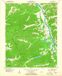
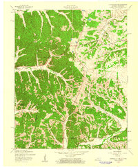
 1953 Canton1954 Print · USGSTrigg County's riverfront is captured here in the early 1950s, showing the land just before the landscape was altered by massive reservoir projects. Local historians can trace family roots through sites like Canton, Peals Chapel, and the Heindrick Cem.
 - 1953 Map of Gracey, 1954 Print
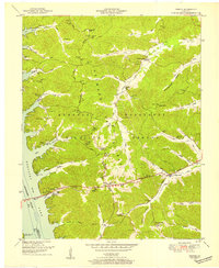
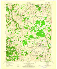
 1953 Gracey1954 Print · USGSChristian and Trigg counties appear here in the early fifties, during a period of steady rail-side growth and established farm life. Genealogists and historians can trace family roots through sites like Cerulean Springs, Montgomery Ch, and Roach Cem.
 - 1953 Map of Cobb, 1954 Print
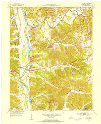
 1953 Cobb1954 Print · USGSSettled farmland along the border of Trigg and Caldwell counties is captured here in the early fifties. Genealogists and historians can trace families via the numerous rural burial grounds like Merrick Cem and churches such as Mt Zion Ch.
 - 1953 Map of Dawson Springs SW, 1954 Print
 1953 Dawson Springs SW1954 Print · USGSMid-century Christian and Caldwell Counties are seen here during a period of rural stability, centered on the wooded expanse of the Pennyrile State Forest. Family historians can trace ancestral roots through several small churches and cemeteries, including Woods Chapel, Vanhooser Cem, and the settlement at Hawkins.
 - 1953 Map of Lamasco, 1954 Print
 1953 Lamasco1954 Print · USGSWestern Kentucky's rural landscape is captured here in the early fifties, just as the traditional river-and-road network remained largely intact. Researchers can trace family history through dozens of landmarks like Trigg Furnace Sch, Siloam Ch, and Parker Cem.2 unique versions available
 - 1953 Map of Cadiz, 1955 Print
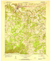 1953 Cadiz1955 Print · USGSTrigg County's river-driven geography is on full display during the early fifties, centering on the town of Cadiz. Genealogists and historians can trace family roots at Oak Grove Sch or locate numerous ancestral plots including Miller Cem and Wallace Cem.
 - 1954 Map of Evansville
 1954 Evansville1954 Print · USGSThe Ohio River borderlands between Indiana and Kentucky appear here during a period of robust industrial and military growth. Genealogists and researchers can trace the rail corridors of the Illinois Central and find landmarks like US Lock and Dam No 48 or Camp Breckinridge.
 - 1955 Map of Fairdealing, 1956 Print
 1955 Fairdealing1956 Print · USGSMarshall County and the Tennessee River shoreline are captured here in the mid-fifties as the region adapted to the new reservoir. Genealogists and local historians can locate many family landmarks, such as Pleasant Hope Church, the Eggner Ferry Bridge, and Fairdealing.3 unique versions available
 - 1955 Map of Birmingham Point, 1956 Print
 1955 Birmingham Point1956 Print · USGSBetween the Rivers in the mid-fifties, this area shows the dramatic transformation of the landscape following the creation of Kentucky Lake. Genealogists and local historians can locate family landmarks like the Birmingham Cem, Nickell Cem, and the Oakland Sch.2 unique versions available
 - 1955 Map of New Concord, 1957 Print
 1955 New Concord1957 Print · USGSCalloway County and the Tennessee River valley are shown here just after the mid-century creation of Kentucky Lake. Local historians can trace established rural settlements like New Concord and Hico, alongside landmark sites like Fort Henry and Russell Chapel.
 - 1955 Map of Golden Pond, 1957 Print
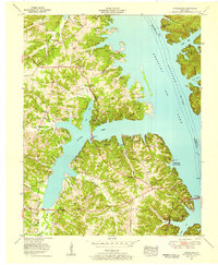
 1955 Golden Pond1957 Print · USGSIn the mid-1950s, the peninsula between the Tennessee and Cumberland rivers was a landscape of deep hollows and new reservoirs. Trace family roots and local history through landmarks like Birmingham Cem, the ruins of Center Furnace, and Paradise Ch.
 - 1956 Map of Dyersburg, 1960 Print
 1956 Dyersburg1960 Print · USGSThe Four Rivers region comes alive in the mid-fifties, capturing the intricate borderlands of Tennessee, Kentucky, and Missouri. Genealogists and historians can trace the rail-and-river networks connecting Dyersburg, Caruthersville, and the shoreline of Reelfoot Lake.4 unique versions available
 - 1956 Map of Nashville, 1971 Print
 1956 Nashville1971 Print · USGSThe Tennessee-Kentucky borderlands come into focus in the mid-1960s as major reservoir projects transformed the Cumberland and Tennessee river valleys. Researchers can trace the rail networks of the Louisville and Nashville and visit sites like Fort Campbell and Fort Donelson National Military Park.2 unique versions available
 - 1957 Map of Johnson Hollow, 1960 Print
 1957 Johnson Hollow1960 Print · USGSThe Kentucky and Tennessee borderlands in the late fifties are defined here by a mix of rural community life and military expansion. Genealogists and historians can locate numerous family burial sites and country churches, including Old Dry Creek Cem, Delmont Sch, and the Fort Campbell Military Reservation.4 unique versions available
 - 1957 Map of Model, 1960 Print
 1957 Model1960 Print · USGSThe Cumberland River valley is caught in a moment of transition during the late fifties as the rising waters of Lake Barkley begin to reshape the state line. Genealogists can trace family landmarks like Tobacconport, the Mt Vernon School, and the Watkins Cemetery before the local geography was permanently altered.
 - 1957 Map of Roaring Spring, 1960 Print
 1957 Roaring Spring1960 Print · USGSThe Kentucky-Tennessee borderlands appear here in the mid-fifties as the military footprint expands. Trace family roots at Gary Cem or explore the settlement patterns around Roaring Spring and the Lafayette post office.3 unique versions available
 - 1957 Map of Model, 1963 Print
 1957 Model1963 Print · USGSThe Tennessee and Kentucky borderlands meet here in the late fifties as the Cumberland River valley prepares for the rising waters of Lake Barkley. Genealogists can trace family landmarks like the Gatlin Cem or explore the rural hubs of Bumpus Mills and Tobaccoport.
Showing maps 1-25 of 28
Top cities of Trigg County
Frequently asked questions
- What are the different types of historical maps available for Trigg County?
- What is the oldest map of Trigg County?
- Where can I purchase historical maps of Trigg County for my home or office?
- Where can I download high-res historical maps of Trigg County?
- Are there historical topographic maps available for Trigg County?
- Is there historical aerial imagery available for Trigg County?
- Where are historical maps of Trigg County sourced from?