1960s Maps of Trigg County, Kentucky
Explore 10 historic maps of Trigg County from the 1960s. These maps offer a rare glimpse into what life looked like during the 1960s — showing old roads, neighborhoods, homes, and landmarks that have changed or disappeared over time.
Whether you're researching your family's past, planning a metal detecting trip, or studying how Trigg County's landscape evolved across the 1960s, these high-resolution maps are a powerful tool for exploring the history of this region.
- Focus on a specific era: All maps on this page are from the 1960s, giving you a focused view of this time period.
- See what’s changed: Compare century-old streets, trails, and buildings to today's modern landscape using overlays and satellite layers.
- Research with precision: Use these maps for genealogy, historical research, land use analysis, or educational projects.
- View, download, or print: Maps are fully viewable online in high resolution, and can be downloaded or printed for your own records.
Start exploring Trigg County's history through authentic maps from the 1960s. This is your window into the past.
Trigg County, KY maps
(10)- 1961 Map of Evansville
 1961 Evansville1961 Print · USGSThe Ohio River valley and its surrounding coalfields are captured here during the late fifties and early sixties. Trace the industrial rail networks of the Illinois Central RR and explore regional landmarks like Mammoth Cave National Park and Angel Mounds State Memorial.2 unique versions available
 - 1967 Map of Fenton, 1968 Print
 1967 Fenton1968 Print · USGSWestern Kentucky’s peninsula between the rivers is captured here in the late sixties as the reservoir system matured. Genealogists and historians can locate Fenton, the Egger Ferry Bridge, and family burial grounds like Jenny Ridge Cem.3 unique versions available
 - 1967 Map of Cadiz, 1968 Print
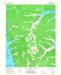
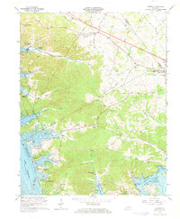
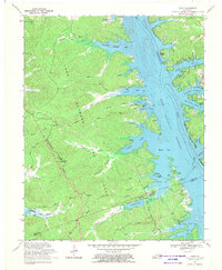
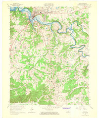 1967 Cadiz1968 Print · USGSCadiz and the surrounding Trigg County countryside are captured here in the late sixties as the region adjusted to the creation of Lake Barkley. Researchers can locate rural landmarks like the McUpton Sch, trace the path of the Cadiz RR, and find family-named sites such as Bedford Spring.2 unique versions available
 - 1967 Map of Birmingham Point, 1968 Print
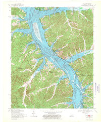
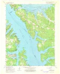 1967 Birmingham Point1968 Print · USGSIn the late sixties, this area between the newly formed Kentucky Lake and Lake Barkley reveals a landscape transformed by water. Researchers can trace the original location of Birmingham, find family burial grounds like Demumbers Cem, and follow the route of The Trace.3 unique versions available
 - 1967 Map of Cobb, 1968 Print
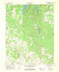
 1967 Cobb1968 Print · USGSTrigg and Caldwell counties are shown in the late sixties as the newly formed Lake Barkley began to reshape the river valley. Genealogists can trace local roots through numerous family landmarks like Hanberry Cem, Wallonia, and Blue Spring Ch.2 unique versions available
 - 1967 Map of Lamasco, 1968 Print
 1967 Lamasco1968 Print · USGSTrigg and Lyon Counties are shown in the late sixties as the waters of Lake Barkley reshape the valley. Genealogists can locate family burial sites like Bethany Cem and Stephens Cem or trace the early growth of Rockcastle.2 unique versions available
 - 1967 Map of Canton, 1968 Print
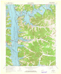 1967 Canton1968 Print · USGSLake Barkley and the Cumberland River define Trigg County in the late sixties as new shoreline developments emerge. Genealogists can trace family names at Liberty Point Cem, McIntire Cem, and rural congregations like Mt Pleasant Ch.2 unique versions available
 - 1967 Map of Dawson Springs SW, 1969 Print
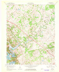
 1967 Dawson Springs SW1969 Print · USGSThe Tradewater River valley in the late 1960s is defined by the creation of Lake Beshear and its winding shoreline. Genealogists and local historians can trace rural communities through landmarks like Vanhooser Cem, New Hope Ch, and the crossroads at Ruth.2 unique versions available
 - 1967 Map of Linton, 1970 Print
 1967 Linton1970 Print · USGSThe Kentucky and Tennessee borderlands appear here in the late sixties as the newly formed Lake Barkley reshaped the river valley. Researchers can trace the layout of Linton, Model, and Tobaccoport alongside landmarks like Big Joe Spring and Fox Ridge.2 unique versions available
 - 1967 Map of Mont, 1970 Print
 1967 Mont1970 Print · USGSThe Land Between the Lakes peninsula in the late sixties shows a landscape reshaped by the Cumberland River impoundment. Researchers can find historic cemeteries and industrial relics, including the Center Furnace (Ruins), Woodson Chapel, and Henderson Chapel Cem.2 unique versions available
End of results
Showing maps 1-10 of 10
Top cities of Trigg County
Frequently asked questions
- What are the different types of historical maps available for Trigg County?
- What is the oldest map of Trigg County?
- Where can I purchase historical maps of Trigg County for my home or office?
- Where can I download high-res historical maps of Trigg County?
- Are there historical topographic maps available for Trigg County?
- Is there historical aerial imagery available for Trigg County?
- Where are historical maps of Trigg County sourced from?