1930s Maps of Trigg County, Kentucky
Explore 7 historic maps of Trigg County from the 1930s. These maps offer a rare glimpse into what life looked like during the 1930s — showing old roads, neighborhoods, homes, and landmarks that have changed or disappeared over time.
Whether you're researching your family's past, planning a metal detecting trip, or studying how Trigg County's landscape evolved across the 1930s, these high-resolution maps are a powerful tool for exploring the history of this region.
- Focus on a specific era: All maps on this page are from the 1930s, giving you a focused view of this time period.
- See what’s changed: Compare century-old streets, trails, and buildings to today's modern landscape using overlays and satellite layers.
- Research with precision: Use these maps for genealogy, historical research, land use analysis, or educational projects.
- View, download, or print: Maps are fully viewable online in high resolution, and can be downloaded or printed for your own records.
Start exploring Trigg County's history through authentic maps from the 1930s. This is your window into the past.
Trigg County, KY maps
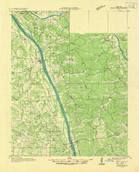
(7)- 1936 Map of Mont
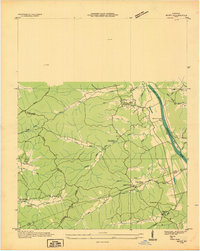 1936 Mont1936 Print · USGSThe Tennessee and Cumberland river basins meet here in the 1930s, showing a landscape of rural post offices and iron-industry remnants. Genealogists can locate family landmarks like Hillman Store, Woods Chapel, and the Fulton Sch.
 - 1936 Map of Fenton
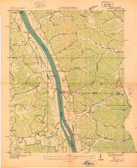
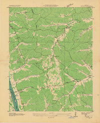 1936 Fenton1936 Print · USGSTrigg County sits at a crossroads of river and road in the mid-1930s, before modern reservoirs reshaped the landscape. Trace the old communities of Golden Pond and Fenton, and locate rural landmarks like Joycetown Cem and Oak Ridge Sch.
 - 1936 Map of Hiatt
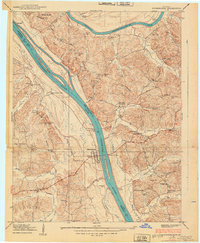
 1936 Hiatt1936 Print · USGSThe Tennessee River corridor in the mid-1930s appears here before the formation of Kentucky Lake forever altered the local shoreline. Genealogists can locate family landmarks like Barnett Cem, rural centers like Faughns Store, and schools such as Collie Sch or Aurora Sch.
 - 1936 Map of Birmingham
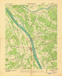 1936 Birmingham1936 Print · USGSThe Tennessee and Cumberland rivers converge in the mid-1930s, showing the riverfront town of Birmingham before the creation of Kentucky Lake. Genealogists and historians can trace numerous family burial sites like Birmingham Cem and rural centers such as Yale Sch and the Birmingham Ferry.
 - 1936 Map of Golden Pond
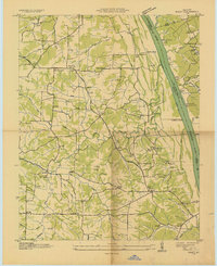
 1936 Golden Pond1936 Print · USGSWestern Kentucky’s river-locked interior is captured here in the mid-1930s, just before the creation of the great lakes. Local researchers can trace family roots at Birmingham or Fenton, and locate industrial landmarks like the Center Furnace and Star Lime Works.
 - 1936 Map of Rushing
 1936 Rushing1936 Print · USGSLife along the Tennessee River is documented here just before major dam projects reshaped the border of Kentucky and Tennessee. Genealogists and historians can trace old river access points like Dilday Landing and local landmarks such as Futrell Store or the Hendon Cem.
 - 1938 Map of Birmingham
 1938 Birmingham1938 Print · USGSThe Tennessee and Cumberland Rivers converge in Lyon County just before the regional landscape was transformed by dam projects. Genealogists can trace family footprints at Birmingham, find rural landmarks like Star Lime Works PO, or locate Harvard Ch and Birmingham Cem.
End of results
Showing maps 1-7 of 7
Top cities of Trigg County
Frequently asked questions
- What are the different types of historical maps available for Trigg County?
- What is the oldest map of Trigg County?
- Where can I purchase historical maps of Trigg County for my home or office?
- Where can I download high-res historical maps of Trigg County?
- Are there historical topographic maps available for Trigg County?
- Is there historical aerial imagery available for Trigg County?
- Where are historical maps of Trigg County sourced from?