1920s Maps of Bowling Green, Kentucky
Explore 4 historic maps of Bowling Green from the 1920s. These maps offer a rare glimpse into what life looked like during the 1920s — showing old roads, neighborhoods, homes, and landmarks that have changed or disappeared over time.
Whether you're researching your family's past, planning a metal detecting trip, or studying how Bowling Green's landscape evolved across the 1920s, these high-resolution maps are a powerful tool for exploring the history of this region.
- Focus on a specific era: All maps on this page are from the 1920s, giving you a focused view of this time period.
- See what’s changed: Compare century-old streets, trails, and buildings to today's modern landscape using overlays and satellite layers.
- Research with precision: Use these maps for genealogy, historical research, land use analysis, or educational projects.
- View, download, or print: Maps are fully viewable online in high resolution, and can be downloaded or printed for your own records.
Start exploring Bowling Green's history through authentic maps from the 1920s. This is your window into the past.
Bowling Green, KY maps
(4)- 1921 Map of Bowling Green, 1955 Print
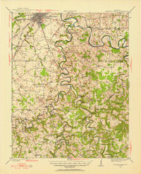 1921 Bowling Green1955 Print · USGSBowling Green and its surrounding counties are shown here just after the Great War, when the Louisville and Nashville railroad fueled regional growth. Genealogists can trace hundreds of family landmarks, from Mussey Mill to schools like Cave Mill School and the remote Antioch Chapel.
 - 1922 Map of Brownsville
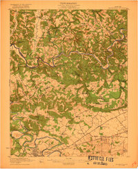 1922 Brownsville1922 Print · USGSEdmonson and Warren Counties are mapped here in the early 1920s, showing a river-centered economy still reliant on ferries and landings. Genealogists can trace family footprints across dozens of country school sites like Poplar Spring School and historic crossings like Sadler Ford.
 - 1923 Map of Bowling Green
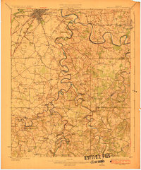 1923 Bowling Green1923 Print · USGSThe Bowling Green area in the early 1920s was a landscape defined by the winding Barren River and the busy Louisville and Nashville Railroad. Researchers can trace ancestral roots through dozens of rural sites like Cassadays Store, Massey Mill, and the Lost River.4 unique versions available
 - 1923 Map of Brownsville
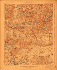 1923 Brownsville1923 Print · USGSThe river-driven economies of Edmonson and Warren counties are preserved here in the early twentieth century. Researchers can trace ancestral locations through dozens of named sites like Bethlehem Church, Dalton Ferry, and rural schoolhouses including Poplar Spring School.3 unique versions available
End of results
Showing maps 1-4 of 4
Top cities near Bowling Green
- Franklin historical maps
- Scottsville historical maps
- Brownsville historical maps
- Smiths Grove historical maps
- Plum Springs historical maps
- Woodburn historical maps
See more
Top neighborhoods of Bowling Green
- Crestmoor historical maps
- Eastland Park historical maps
- Lost River historical maps
- Briarwood Manor historical maps
- Springhill historical maps
- Delafield historical maps
See more
Frequently asked questions
- What are the different types of historical maps available for Bowling Green?
- What is the oldest map of Bowling Green?
- Where can I purchase historical maps of Bowling Green for my home or office?
- Where can I download high-res historical maps of Bowling Green?
- Are there historical topographic maps available for Bowling Green?
- Is there historical aerial imagery available for Bowling Green?
- Where are historical maps of Bowling Green sourced from?