1990s Maps of Bowling Green, Kentucky
Explore 2 historic maps of Bowling Green from the 1990s. These maps offer a rare glimpse into what life looked like during the 1990s — showing old roads, neighborhoods, homes, and landmarks that have changed or disappeared over time.
Whether you're researching your family's past, planning a metal detecting trip, or studying how Bowling Green's landscape evolved across the 1990s, these high-resolution maps are a powerful tool for exploring the history of this region.
- Focus on a specific era: All maps on this page are from the 1990s, giving you a focused view of this time period.
- See what’s changed: Compare century-old streets, trails, and buildings to today's modern landscape using overlays and satellite layers.
- Research with precision: Use these maps for genealogy, historical research, land use analysis, or educational projects.
- View, download, or print: Maps are fully viewable online in high resolution, and can be downloaded or printed for your own records.
Start exploring Bowling Green's history through authentic maps from the 1990s. This is your window into the past.
Bowling Green, KY maps
(2)- 1993 Map of Bowling Green North, 1996 Print
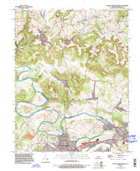 1993 Bowling Green North1996 Print · USGSWarren County in the early nineties shows the suburban growth of Bowling Green meeting the rural traditions of the Barren River hills. Researchers can trace family sites at Taylor Cem or locate historic community hubs like Richardsville Sch and Anna Ch.
 - 1993 Map of Bowling Green South, 1996 Print
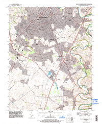 1993 Bowling Green South1996 Print · USGSWarren County in the early 1990s shows the suburban expansion of Bowling Green alongside its deep agricultural and industrial roots. Genealogists can trace family landmarks near Plano and Memphis Junction, or locate burials at Trinity Cem and St Joseph Cem.
End of results
Showing maps 1-2 of 2
Top cities near Bowling Green
- Franklin historical maps
- Scottsville historical maps
- Brownsville historical maps
- Smiths Grove historical maps
- Plum Springs historical maps
- Woodburn historical maps
See more
Top neighborhoods of Bowling Green
- Crestmoor historical maps
- Eastland Park historical maps
- Lost River historical maps
- Briarwood Manor historical maps
- Springhill historical maps
- Delafield historical maps
See more
Frequently asked questions
- What are the different types of historical maps available for Bowling Green?
- What is the oldest map of Bowling Green?
- Where can I purchase historical maps of Bowling Green for my home or office?
- Where can I download high-res historical maps of Bowling Green?
- Are there historical topographic maps available for Bowling Green?
- Is there historical aerial imagery available for Bowling Green?
- Where are historical maps of Bowling Green sourced from?