1990s Maps of Bruly McCall, Louisiana
Explore 1 historic maps of Bruly McCall from the 1990s. These maps offer a rare glimpse into what life looked like during the 1990s — showing old roads, neighborhoods, homes, and landmarks that have changed or disappeared over time.
Whether you're researching your family's past, planning a metal detecting trip, or studying how Bruly McCall's landscape evolved across the 1990s, these high-resolution maps are a powerful tool for exploring the history of this region.
- Focus on a specific era: All maps on this page are from the 1990s, giving you a focused view of this time period.
- See what’s changed: Compare century-old streets, trails, and buildings to today's modern landscape using overlays and satellite layers.
- Research with precision: Use these maps for genealogy, historical research, land use analysis, or educational projects.
- View, download, or print: Maps are fully viewable online in high resolution, and can be downloaded or printed for your own records.
Start exploring Bruly McCall's history through authentic maps from the 1990s. This is your window into the past.
Bruly McCall, LA maps
(1)- 1999 Map of Belle Rose, 2000 Print
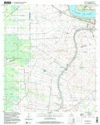 1999 Belle Rose2000 Print · USGSAssumption and Ascension Parishes are shown at the turn of the millennium as the local economy balances traditional bayou settlement with modern industry. Trace the historical footprint of Donaldsonville and small communities like Belle Alliance or Sweet Home.
End of results
Showing maps 1-1 of 1
Top cities near Bruly McCall
- St. George historical maps
- Prairieville historical maps
- Gonzales historical maps
- Donaldsonville historical maps
- Plaquemine historical maps
- White Castle historical maps
See more
Frequently asked questions
- What are the different types of historical maps available for Bruly McCall?
- What is the oldest map of Bruly McCall?
- Where can I purchase historical maps of Bruly McCall for my home or office?
- Where can I download high-res historical maps of Bruly McCall?
- Are there historical topographic maps available for Bruly McCall?
- Is there historical aerial imagery available for Bruly McCall?
- Where are historical maps of Bruly McCall sourced from?