1930s Maps of Avoyelles Parish, Louisiana
Explore 3 historic maps of Avoyelles Parish from the 1930s. These maps offer a rare glimpse into what life looked like during the 1930s — showing old roads, neighborhoods, homes, and landmarks that have changed or disappeared over time.
Whether you're researching your family's past, planning a metal detecting trip, or studying how Avoyelles Parish's landscape evolved across the 1930s, these high-resolution maps are a powerful tool for exploring the history of this region.
- Focus on a specific era: All maps on this page are from the 1930s, giving you a focused view of this time period.
- See what’s changed: Compare century-old streets, trails, and buildings to today's modern landscape using overlays and satellite layers.
- Research with precision: Use these maps for genealogy, historical research, land use analysis, or educational projects.
- View, download, or print: Maps are fully viewable online in high resolution, and can be downloaded or printed for your own records.
Start exploring Avoyelles Parish's history through authentic maps from the 1930s. This is your window into the past.
Avoyelles Parish, LA maps
(3)- 1935 Map of Turkey Creek
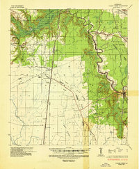 1935 Turkey Creek1935 Print · USGSLouisiana's central parish borderlands come alive in the mid-1930s, showing a landscape defined by meandering bayous and early industrial corridors. Trace the path of the Texas Louisiana and Gulf RR or find family landmarks like Johnson Ldg and Lake Cove Sch.
 - 1935 Map of Tooleys, 1936 Print
 1935 Tooleys1936 Print · USGSThe alluvial wetlands of Concordia and Catahoula Parishes are documented here during the mid-1930s when river life revolved around local landings. Researchers can trace family roots at Larto Sch, identify ancestral sites near the B M Graveyard, or locate early homesteads by Island Bayou Ldg.
 - 1939 Map of Artonish, 1945 Print
 1939 Artonish1945 Print · USGSThe river-and-rail economy of the Louisiana-Mississippi border is frozen in time just before the mid-century, showing the dense settlement of the bottomlands. Genealogists can trace family roots through numerous local landmarks like Fort Adams, Singleton Chapel & Cem, and the Black Hawk Plantation.
End of results
Showing maps 1-3 of 3
Top cities of Avoyelles Parish
- Marksville historical maps
- Bunkie historical maps
- Cottonport historical maps
- Simmesport historical maps
- Mansura historical maps
- Moreauville historical maps
See more
Frequently asked questions
- What are the different types of historical maps available for Avoyelles Parish?
- What is the oldest map of Avoyelles Parish?
- Where can I purchase historical maps of Avoyelles Parish for my home or office?
- Where can I download high-res historical maps of Avoyelles Parish?
- Are there historical topographic maps available for Avoyelles Parish?
- Is there historical aerial imagery available for Avoyelles Parish?
- Where are historical maps of Avoyelles Parish sourced from?