1935 Map of Turkey Creek
USGS Topo · Published 1935About this map
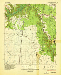
Bayou Cocodrie and its complex network of tributaries define this mid-1930s landscape at the intersection of Evangeline, Rapides, and St. Landry parishes. The region is characterized by a mix of established rail corridors and the emerging infrastructure of natural gas transport, evidenced by the Gulf Texas Louisiana Pipe Line cutting across the central plains. Smaller settlements like Nobrac and Pine Prairie are connected by a series of numbered state routes, while the eastern edge of the map shows the meandering course of Bayou Chicot near the St Landry Parish line.
Find a feature on this map
59 named features on this map. Tap any name to fly to it.
Don’t see what you’re looking for? This feature index may not catch every label — zoom into the map to look around manually.
Map Details
Editions of this 1935 Turkey Creek Map
This is the sole edition of this map. No revisions or reprints were ever made.
Historical Maps of Bunkie Through Time
3 maps found