
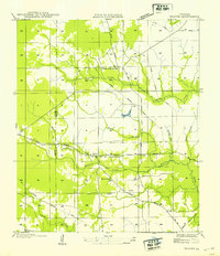
1949 Map of Glenmora
USGS Topo · Published 1949About this map
The timber-dependent landscape of central Louisiana is captured here during the late 1940s, centered on the grid of Glenmora. The mapping reveals a transition in transportation, where the Missouri Pacific Railroad and U S Highway No 165 serve as the primary north-south arteries. Meanwhile, the web of Old Logging Railroad Grade labels threading through the surrounding woods points to the region's intensive lumber history, showing how former rail beds were repurposed or left as traces in the terrain.
Find a feature on this map
20 named features on this map. Tap any name to fly to it.
Don’t see what you’re looking for? This feature index may not catch every label — zoom into the map to look around manually.
Map Details
Editions of this 1949 Glenmora Map
This is the sole edition of this map. No revisions or reprints were ever made.
Other maps of this area

1935 · Beaver
USGS Topo · 1:31,680

1935 · Pawnee
USGS Topo · 1:31,680

1935 · Oakdale
USGS Topo · 1:31,680

1935 · Turkey Creek
USGS Topo · 1:62,500

1935 · Lecompte
USGS Topo · 1:62,500

1942 · Oakdale
USGS Topo · 1:62,500

1949 · Turkey Creek
USGS Topo · 1:62,500

1952 · Lake Charles
USGS Topo · 1:250,000

1953 · Alexandria
USGS Topo · 1:250,000
1954 · Beaver
USGS Topo · 1:31,680